Maps of Region Nordschwarzwald

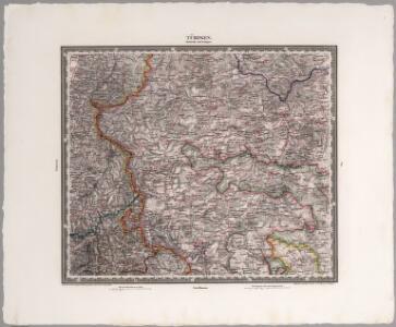
Tubingen
1 : 200000 Herder, Benjamin
Des Herzogthums Würtemberg westsüdliche Aemter mit der freyen Reichsstadt Reutlingen
1 Karte : Kupferdruck ; 23 x 26 cm Reilly F. J. J. von Reilly
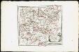
March. Badensis pars, duc. septentrio Wurtenbergici pars
Bádensko (Německo)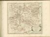
Des Herzogthums Würtemberg westsüdliche Aemter mit der freyen Reichsstadt Reutlingen : Nro. 188
Reilly, Franz Johann Joseph von
178. Sigmaringen, uit: Topographische Uebersichtskarte des Deutschen Reiches / herausgegeben v. d. Kartogr. Abt. d. Königl. Preuß. Landesaufnahme
1 : 200000 titelvariant: Topogr. Übersichtskarte des Deutschen Reiches; Annotatie: Titel boven bladen ook: Topogr. Übersichtskarte des Deutschen Reiches; Annotatie geografische gegevens: Op elk blad twee maatstokken: 10 Kilometer = 5,5 cm; 1 geogr. Meile = 3,6 cm; Legenda onder op elk blad Königlich Preußische Landesaufnahme. Kartographische Abtheilung [S.l : Königlich Preußische Landesaufnahme, Kartographische Abtheilung]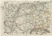
Geographica Provinciarum Sveviae Descriptio =
Mollova mapová sbírka Hurter, Johann Christoph Bodenehr, Gabriel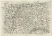
Geographica Provinciarum Sveviae Descriptio =
Mollova mapová sbírka Hurter, Johann Christoph Bodenehr, Johann Georg
Suevia Universa :
1 : 170000 Mollova mapová sbírka Michal, Jacques de Seutter, Matthäus Seutter, Matthäus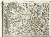
Geographica Provinciarum Sveviae Descriptio =
Mollova mapová sbírka Hurter, Johann Christoph Bodenehr, Gabriel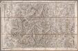
Rottweil
1 : 100000 Annotatie: Linksonder: T-28 [Paris : Depôt de la Guerre]
Le Theatre de la Guerre Sur le Haut Rhein
1 : 142000 Mollova mapová sbírka Sanson, Guillaume
Le Flambeau de la Guerre Allumee au Rhin
Mollova mapová sbírka Delisle, Guillaume Schenk, Peter II
Le Flambeau de la Guerre Allumee au Rhin
Mollova mapová sbírka Delisle, Guillaume Schenk, Peter II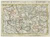
Tübingen mit dero Gegend auf 2 Stud etc.
1 : 150000 Mollova mapová sbírka Bodenehr, Gabriel Bodenehr, Gabriel
Hohenzollern Hechingische Forst-Carte welche Occasione derer in solchem Territorio Ao. 1733 enstandenen Unruhe
1 : 50000 Mollova mapová sbírka Freusberg, Marquard Rudolph von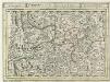
Schiltach, mit dero Gegend auf 2 Stunden.
1 : 150000 Mollova mapová sbírka Bodenehr, Gabriel H., R.
Le Flambeau de la Guerre Allumee au Rhin
Mollova mapová sbírka Delisle, Guillaume Schenk, Peter II
Übersichtskarte über die Erzgänge des Kinzigthales
1 : 50000 Chr. Fr. Müller'sche Hofbuchhandlung
Geologische Karte der Umgebungen der Renchbäder
1 : 50000 Sandberger, Fr. Chr. Fr. Müller'sche Hofbuchhandlung
Geologische Karte der Umgebungen von Baden
1 : 50000 Südblatt Sandberger, Fr. Chr. Fr. Müller'sche Hofbuchhandlung
Le Flambeau de la Guerre Allumee au Rhin
Mollova mapová sbírka Delisle, Guillaume Schenk, Peter II
Blatt 109: Möffingen, uit: Topographische Karte von Württemberg im Massstab 1:25.000 / hrsg. vom Statistischen Landesamt
1 : 25000 titelvariant: Topographische Karte des Königreichs Württemberg im Massstabe 1:25.000; Annotatie: Titelvariant: Topographische Karte des Königreichs Württemberg im Massstabe 1:25.000; Incompleet (4 bl. aanwezig) Württembergisches Statistisches Landesamt [Stuttgart : Statistisches Landesamt]
Meßtischblatt [7820] : Stetten am kalten Markt, 1883
1 : 250000 Stetten am kalten Markt. - [Ausg.] 1879 u. 83. - 1:25000. - Leipzig: Giesecke & Devrient, 1883. - 1 Kt.
Meßtischblatt [7819] : Schwenningen, 1883
1 : 250000 Schwenningen. - [Ausg.] 1879 u. 83. - 1:25000. - Leipzig: Giesecke & Devrient, 1883. - 1 Kt.
Meßtischblatt [7818] : Wehingen (Württ.). Wilflingen (Preuß.), 1911
1 : 250000 Wehingen (Württ.). Wilflingen (Preuß.). - 1:25000. - Stuttgart, 1911. - 1 Kt.
Meßtischblatt [7817] : Niedereschach, 1911
1 : 250000 Niedereschach. - 2. Aufl., rev. 1904/1905, Nachtr. bis 1910. - 1:25000. - Leipzig: Giesecke & Devrient, 1911. - 1 Kt.
Meßtischblatt [7816] : Königsfeld, 1910
1 : 250000 Königsfeld. - 2. Aufl., Nachtr. bis 1910. - 1:25000. - Leipzig: Giesecke & Devrient, 1910. - 1 Kt.
Meßtischblatt [7815] : Triberg, 1916
1 : 250000 Triberg. - Steindr.-Ausg., 2. Aufl. - 1:25000. - Leipzig: Giesecke & Devrient, 1916. - 1 Kt.