Maps of Landkreis Rottweil

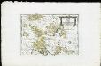
Meßtischblatt [7817] : Niedereschach, 1911
1 : 250000 Niedereschach. - 2. Aufl., rev. 1904/1905, Nachtr. bis 1910. - 1:25000. - Leipzig: Giesecke & Devrient, 1911. - 1 Kt.
Le Flambeau de la Guerre Allumee au Rhin
Mollova mapová sbírka Delisle, Guillaume Schenk, Peter II
[Geologische Karte der Umgebungen von Triberg und Donaueschingen]
1 : 50000 Ostblatt Vogelgesang Chr. Fr. Müller'sche Hofbuchhandlung
178. Sigmaringen, uit: Topographische Uebersichtskarte des Deutschen Reiches / herausgegeben v. d. Kartogr. Abt. d. Königl. Preuß. Landesaufnahme
1 : 200000 titelvariant: Topogr. Übersichtskarte des Deutschen Reiches; Annotatie: Titel boven bladen ook: Topogr. Übersichtskarte des Deutschen Reiches; Annotatie geografische gegevens: Op elk blad twee maatstokken: 10 Kilometer = 5,5 cm; 1 geogr. Meile = 3,6 cm; Legenda onder op elk blad Königlich Preußische Landesaufnahme. Kartographische Abtheilung [S.l : Königlich Preußische Landesaufnahme, Kartographische Abtheilung]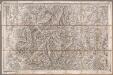
Rottweil
1 : 100000 Annotatie: Linksonder: T-28 [Paris : Depôt de la Guerre]
Geographica Provinciarum Sveviae Descriptio =
Mollova mapová sbírka Hurter, Johann Christoph Bodenehr, Johann Georg
Geographica Provinciarum Sveviae Descriptio =
Mollova mapová sbírka Hurter, Johann Christoph Bodenehr, Gabriel
Des Herzogthums Würtemberg westsüdliche Aemter mit der freyen Reichsstadt Reutlingen : Nro. 188
Reilly, Franz Johann Joseph von
Fernere Erweiterung unserer weiteren Kriegs Progressen von den 11ten Aug: biß 12ten Octob:
Mollova mapová sbírka Lidl, Johann Jakob Lidl, Johann Jacob
Tubingen
1 : 200000 Herder, Benjamin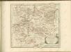

Freiburg 141, uit: [W. Liebenow's Special-Karte von Mittel-Europa]
1 : 300000 titelvariant: W. Liebenow's Mittel-Europa; Annotatie: Titel boven de bladen: W. Liebenow's Mittel-Europa Johannes Wilhelm Liebenow 1822-1897 Hannover : Hermann Oppermann
Freiburg 141, uit: Special-Karte von Mittel-Europa / nach amtlichen Quellen bearbeitet von W. Liebenow
1 : 300000 titelvariant: W. Liebenow's Mittel-Europa; Annotatie: Titel boven de bladen: W. Liebenow's Mittel-Europa Johannes Wilhelm Liebenow 1822-1897 Frankfurt a. M. : Ludwig Ravenstein
March. Badensis pars, duc. septentrio Wurtenbergici pars
Bádensko (Německo)
Des Herzogthums Würtemberg westsüdliche Aemter mit der freyen Reichsstadt Reutlingen
1 Karte : Kupferdruck ; 23 x 26 cm Reilly F. J. J. von Reilly
Die Lande des Fürsten von Fürstenberg oder die Landgrafschaften Stühlingen und Baar die Grafschaft Heiligenberg und die Herrschaften Gundelfingen Möskirch Jungnau und Trochtelfingen Mit der Schwarzenbergischen Landgrafschaft Klettgau ...
Reilly, Franz Johann Joseph von
Die Lande des Fürsten von Fürstenberg
1 Karte : Kupferdruck ; 23 x 26 cm Reilly F. J. J. von Reilly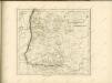

Provincia Brisgoia avst. ant
1 Karte : Kupferdruck ; 57 x 47 cm Homann Johann Baptist Homann
Accurata delineatio Brisgoviæ
1 Karte : Kupferdruck ; 56 x 48 cm Seutter; Drentwett Matthäus Seutter
Die Landgrafschaft Nellenburg die Landvogtey Altorf die Grafschaft Hohenberg und die kleinern durch das östreichische Schwaben zerstreuten Besitzungen mit der Stadt Kostanz und den vier Donaustaedten : Nro. 153
Reilly, Franz Johann Joseph von
Die obere Markgrafschaft Baaden oder die Markgrafschaft Hochberg
1 Karte : Kupferdruck ; 21 x 24 cm Reilly F. J. J. von Reilly
Le Theatre de Bellone :
Mollova mapová sbírka Schenk, Pieter Braakman, Adriaan
Carte topographique d'Allemagne
1 : 218000 Alsasko (Francie) Jaeger, Johann Wilhelm Abraham Facius, Johann Gottlieb chez I.W.A. Iaeger
Carte topographique d'Allemagne
1 : 218000 Alsasko (Francie) Jaeger, Johann Wilhelm Abraham I. W. A. Iaeger
Generalkarte von Württemberg: Blatt III
1 : 1500000 Terrainzeichnung: Bach, Topograf und Hauptmann Lithografie: Rebmann und Sommer Herausgeber: K. statistisch-topografisches Büro
Imp. Caes. Carolo VI. Avgvsto pio victori gentis svae sideri felicissimo chorographiam hanc exhibentem primar. regionvm Habspvrgicar. sitvm positvmq. brevibvs exterarvm ditionvm intervallis vt permistvm et implicatvm ita variis tvrbis expositvm nec non vltimos Imperii Germ. terminos perpetva transitvvm obsidionvm Hibernorvm coactionvm vexatione agitatos antiqvae fidei et invictae testes pietatis svpplexdicat provincia Brisgoia
1 : 42000 Homann, Johann Baptist Ioh. Bapt. Homann
Cursus Rheni supra Argentoratum et Regiones Adiacentes
1 : 2900000 Mollova mapová sbírka Seutter, Matthäus Seutter, Matthäus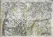
![Meßtischblatt [7817] : Niedereschach, 1911](https://images-2.georeferencer.com/images/iiif/980925687733/full/,300/0/native.jpg)

