Maps of Landkreis Rottweil
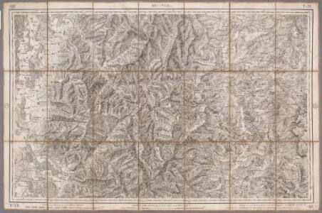
Rottweil
1 : 100000 Annotatie: Linksonder: T-28 [Paris : Depôt de la Guerre]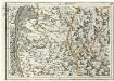
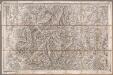
Geographica Provinciarum Sveviae Descriptio =
Mollova mapová sbírka Hurter, Johann Christoph Bodenehr, Gabriel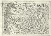
Geographica Provinciarum Sveviae Descriptio =
Mollova mapová sbírka Hurter, Johann Christoph Bodenehr, Johann Georg
Le Theatre de la Guerre Sur le Haut Rhein
1 : 142000 Mollova mapová sbírka Sanson, Guillaume
177. Offenburg, uit: Topographische Uebersichtskarte des Deutschen Reiches / herausgegeben v. d. Kartogr. Abt. d. Königl. Preuß. Landesaufnahme
1 : 200000 titelvariant: Topogr. Übersichtskarte des Deutschen Reiches; Annotatie: Titel boven bladen ook: Topogr. Übersichtskarte des Deutschen Reiches; Annotatie geografische gegevens: Op elk blad twee maatstokken: 10 Kilometer = 5,5 cm; 1 geogr. Meile = 3,6 cm; Legenda onder op elk blad Königlich Preußische Landesaufnahme. Kartographische Abtheilung [S.l : Königlich Preußische Landesaufnahme, Kartographische Abtheilung]
Le Flambeau de la Guerre Allumee au Rhin
Mollova mapová sbírka Delisle, Guillaume Schenk, Peter II
Le Flambeau de la Guerre Allumee au Rhin
Mollova mapová sbírka Delisle, Guillaume Schenk, Peter II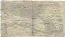
Charte über das Grosherzogthum Baaden
1 : 180000 Bádensko (Německo)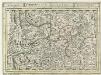
Schiltach, mit dero Gegend auf 2 Stunden.
1 : 150000 Mollova mapová sbírka Bodenehr, Gabriel H., R.
Übersichtskarte über die Erzgänge des Kinzigthales
1 : 50000 Chr. Fr. Müller'sche Hofbuchhandlung
Le Flambeau de la Guerre Allumee au Rhin
Mollova mapová sbírka Delisle, Guillaume Schenk, Peter II
[Geologische Karte der Umgebungen von Lahr und Offenburg]
1 : 50000 Südblatt Platz, Ph. Chr. Fr. Müller'sche Hofbuchhandlung
[Geologische Karte der Umgebungen von Triberg und Donaueschingen]
1 : 50000 Ostblatt Vogelgesang Chr. Fr. Müller'sche Hofbuchhandlung
[Geologische Karte der Umgebungen von Triberg und Donaueschingen]
1 : 50000 Westblatt Vogelgesang Chr. Fr. Müller'sche Hofbuchhandlung
Geologische Karte der Umgebungen der Bäder Glotterthal und Suggenthal
1 : 50000 Schill, Julius Chr. Fr. Müller'sche Hofbuchhandlung
[Geologische Karte der Umgebungen von Lahr und Offenburg]
1 : 50000 Nordblatt Platz, Ph. Chr. Fr. Müller'sche Hofbuchhandlung
Mappa, in quâ Tractus Regionis Inter Doneschingā et Veros Danubii Fontes interjacentis Geographicè repraesentatur Ut hoc etiam modo facilè cuivis appareat, quàm minus rectè in Doneschingâ arce fontes Danubii quaerantur; quam naturali è contrà iure illa scaturigo aquae est prope Brukelrein in altissimo totius sylvae Herzyniae monte pro Veris Danubii fontibus habenda sit
1 : 200000 Mollova mapová sbírka Marsili, Luigi Ferdinando
Geologische Karte der Umgebungen der Renchbäder
1 : 50000 Sandberger, Fr. Chr. Fr. Müller'sche Hofbuchhandlung
Meßtischblatt [7917] : Dürrheim, 1884
1 : 250000 Dürrheim. - [Ausg.] 1877 u. 1884. - 1:25000. - Leipzig: Giesecke & Devrient, 1884. - 1 Kt.
Meßtischblatt [7916] : Villingen, 1908
1 : 250000 Villingen. - Steindruckausg., Nachtr. bis 1908. - 1:25000. - Leipzig: Giesecke & Devrient, 1908. - 1 Kt.
Meßtischblatt [7915] : Furtwangen, 1879
1 : 250000 Furtwangen. - 1:25000. - Leipzig: Giesecke & Devrient, 1879. - 1 Kt.
Meßtischblatt [7913] : Waldkirch, 1878
1 : 250000 Waldkirch. - 1:25000. - Leipzig: Giesecke & Devrient, 1878. - 1 Kt.
Meßtischblatt [7914] : St. Peter, 1928
1 : 250000 St. Peter. - Hrsg. 1877, revid. 1907, wichtigere Nachtr. bis 1928. - 1:25000. - Leipzig: Giesecke & Devrient, 1928. - 1 Kt.
Meßtischblatt [7817] : Niedereschach, 1911
1 : 250000 Niedereschach. - 2. Aufl., rev. 1904/1905, Nachtr. bis 1910. - 1:25000. - Leipzig: Giesecke & Devrient, 1911. - 1 Kt.
Meßtischblatt [7816] : Königsfeld, 1910
1 : 250000 Königsfeld. - 2. Aufl., Nachtr. bis 1910. - 1:25000. - Leipzig: Giesecke & Devrient, 1910. - 1 Kt.
Meßtischblatt [7815] : Triberg, 1916
1 : 250000 Triberg. - Steindr.-Ausg., 2. Aufl. - 1:25000. - Leipzig: Giesecke & Devrient, 1916. - 1 Kt.
Meßtischblatt [7813] : Emmendingen, 1878
1 : 250000 Emmendingen. - 1:25000. - Leipzig: Giesecke & Devrient, 1878. - 1 Kt.
Meßtischblatt [7814] : Elzach, 1884
1 : 250000 Elzach. - [Ausg.] 1877 u. 1884. - 1:25000. - Leipzig: Giesecke & Devrient, 1884. - 1 Kt.
Meßtischblatt [7717] : Oberndorf, 1908
1 : 250000 Oberndorf. - 1:25000. - Stuttgart, 1908. - 1 Kt.