Maps of Schwarzwald-Baar-Kreis

Meßtischblatt [7916] : Villingen, 1908
1 : 250000 Villingen. - Steindruckausg., Nachtr. bis 1908. - 1:25000. - Leipzig: Giesecke & Devrient, 1908. - 1 Kt.
[Geologische Karte der Umgebungen von Triberg und Donaueschingen]
1 : 50000 Ostblatt Vogelgesang Chr. Fr. Müller'sche Hofbuchhandlung
Mappa, in quâ Tractus Regionis Inter Doneschingā et Veros Danubii Fontes interjacentis Geographicè repraesentatur Ut hoc etiam modo facilè cuivis appareat, quàm minus rectè in Doneschingâ arce fontes Danubii quaerantur; quam naturali è contrà iure illa scaturigo aquae est prope Brukelrein in altissimo totius sylvae Herzyniae monte pro Veris Danubii fontibus habenda sit
1 : 200000 Mollova mapová sbírka Marsili, Luigi Ferdinando
Le Flambeau de la Guerre Allumee au Rhin
Mollova mapová sbírka Delisle, Guillaume Schenk, Peter II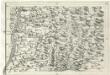
Geographica Provinciarum Sveviae Descriptio =
Mollova mapová sbírka Hurter, Johann Christoph Bodenehr, Johann Georg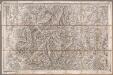
Rottweil
1 : 100000 Annotatie: Linksonder: T-28 [Paris : Depôt de la Guerre]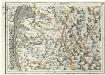
Geographica Provinciarum Sveviae Descriptio =
Mollova mapová sbírka Hurter, Johann Christoph Bodenehr, Gabriel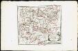
Des Herzogthums Würtemberg westsüdliche Aemter mit der freyen Reichsstadt Reutlingen : Nro. 188
Reilly, Franz Johann Joseph von
Fernere Erweiterung unserer weiteren Kriegs Progressen von den 11ten Aug: biß 12ten Octob:
Mollova mapová sbírka Lidl, Johann Jakob Lidl, Johann Jacob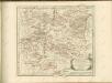

Freiburg 141, uit: [W. Liebenow's Special-Karte von Mittel-Europa]
1 : 300000 titelvariant: W. Liebenow's Mittel-Europa; Annotatie: Titel boven de bladen: W. Liebenow's Mittel-Europa Johannes Wilhelm Liebenow 1822-1897 Hannover : Hermann Oppermann
Freiburg 141, uit: Special-Karte von Mittel-Europa / nach amtlichen Quellen bearbeitet von W. Liebenow
1 : 300000 titelvariant: W. Liebenow's Mittel-Europa; Annotatie: Titel boven de bladen: W. Liebenow's Mittel-Europa Johannes Wilhelm Liebenow 1822-1897 Frankfurt a. M. : Ludwig Ravenstein
Des Herzogthums Würtemberg westsüdliche Aemter mit der freyen Reichsstadt Reutlingen
1 Karte : Kupferdruck ; 23 x 26 cm Reilly F. J. J. von Reilly
Die obere Markgrafschaft Baden oder die Markgrafschaft Hochberg, Landgrafschaft Sausenberg, und die Herrschaften Röteln und Baadenweiler mit den Herrschaften Hausen und Hohengeroldseck,...
Reilly, Franz Johann Joseph von
Die Lande des Fürsten von Fürstenberg oder die Landgrafschaften Stühlingen und Baar die Grafschaft Heiligenberg und die Herrschaften Gundelfingen Möskirch Jungnau und Trochtelfingen Mit der Schwarzenbergischen Landgrafschaft Klettgau ...
Reilly, Franz Johann Joseph von
Die Lande des Fürsten von Fürstenberg
1 Karte : Kupferdruck ; 23 x 26 cm Reilly F. J. J. von Reilly

Provincia Brisgoia avst. ant
1 Karte : Kupferdruck ; 57 x 47 cm Homann Johann Baptist Homann
Accurata delineatio Brisgoviæ
1 Karte : Kupferdruck ; 56 x 48 cm Seutter; Drentwett Matthäus Seutter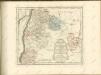

Die obere Markgrafschaft Baaden oder die Markgrafschaft Hochberg
1 Karte : Kupferdruck ; 21 x 24 cm Reilly F. J. J. von Reilly
Le Theatre de Bellone :
Mollova mapová sbírka Schenk, Pieter Braakman, Adriaan
Les frontieres de Lorraine et de la comte de Bourgogne la Haute Alsace divisée en balliages et seigneuries tant de ca que de la le Rhin ou sont le Suntgaw le Breisgaw les quatre villes forestieres partie des montagnes de Vosges les estats du comté de Montbeliard les Montagnes Noires meridionales et partie de la Souabe et des Suisses levé sur les lieux penda[n]t les guerres
1 : 106000 Alsasko (Francie) Sengre, Henri Iaillot
Carte topographique d'Allemagne
1 : 218000 Alsasko (Francie) Jaeger, Johann Wilhelm Abraham Facius, Johann Gottlieb chez I.W.A. Iaeger
Carte topographique d'Allemagne
1 : 218000 Alsasko (Francie) Jaeger, Johann Wilhelm Abraham I. W. A. Iaeger
Suevia universa IX. tabulis delineata, 7
1 Blatt : s.n.
Generalkarte von Württemberg: Blatt III
1 : 1500000 Terrainzeichnung: Bach, Topograf und Hauptmann Lithografie: Rebmann und Sommer Herausgeber: K. statistisch-topografisches Büro
Imp. Caes. Carolo VI. Avgvsto pio victori gentis svae sideri felicissimo chorographiam hanc exhibentem primar. regionvm Habspvrgicar. sitvm positvmq. brevibvs exterarvm ditionvm intervallis vt permistvm et implicatvm ita variis tvrbis expositvm nec non vltimos Imperii Germ. terminos perpetva transitvvm obsidionvm Hibernorvm coactionvm vexatione agitatos antiqvae fidei et invictae testes pietatis svpplexdicat provincia Brisgoia
1 : 42000 Homann, Johann Baptist Ioh. Bapt. Homann
Cursus Rheni supra Argentoratum et Regiones Adiacentes
1 : 2900000 Mollova mapová sbírka Seutter, Matthäus Seutter, Matthäus
![Meßtischblatt [7916] : Villingen, 1908](https://images-2.georeferencer.com/images/iiif/037610904965/full/,300/0/native.jpg)

