Maps of Landkreis Freudenstadt

Le Flambeau de la Guerre Allumee au Rhin
Mollova mapová sbírka Delisle, Guillaume Schenk, Peter II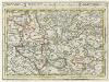
Tübingen mit dero Gegend auf 2 Stud etc.
1 : 150000 Mollova mapová sbírka Bodenehr, Gabriel Bodenehr, Gabriel
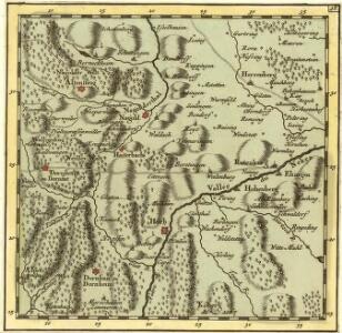
Hohenzollern Hechingische Forst-Carte welche Occasione derer in solchem Territorio Ao. 1733 enstandenen Unruhe
1 : 50000 Mollova mapová sbírka Freusberg, Marquard Rudolph von
Meßtischblatt [7519] : Rottenburg (Württ.). Bietenhausen (Preuß.), 1909
1 : 250000 Rottenburg (Württ.). Bietenhausen (Preuß.). - 1:25000. - Stuttgart, 1909. - 1 Kt.
Meßtischblatt [7518] : Horb (Württ.). Imnau (Preuß.), 1909
1 : 250000 Horb (Württ.). Imnau (Preuß.). - 1:25000. - Stuttgart, 1909. - 1 Kt.
Meßtischblatt [7517] : Dornstetten (Württ.). Dettingen (Preuß.), 1909
1 : 250000 Dornstetten (Württ.). Dettingen (Preuß.). - 1:25000. - Stuttgart, 1909. - 1 Kt.
Meßtischblatt [7419] : Herrenberg, 1901
1 : 250000 Herrenberg. - 1:25000. - Stuttgart, 1901. - 1 Kt.
Meßtischblatt [7418] : Nagold, 1931
1 : 250000 Nagold. - 1:25000. - Stuttgart, 1931. - 1 Kt.
Meßtischblatt [7417] : Altensteig, 1931
1 : 250000 Altensteig. - 1:25000. - Stuttgart, 1931. - 1 Kt.
Meßtischblatt [7619] : Hechingen (Preuß.) Bodelshausen (Württ.), 1910
1 : 250000 Hechingen (Preuß.) Bodelshausen (Württ.). - 1:25000. - Stuttgart, 1910. - 1 Kt.
Meßtischblatt [7618] : Haigerloch (Preuß.) Binsdorf (Württ.), 1910
1 : 250000 Haigerloch (Preuß.) Binsdorf (Württ.). - 1:25000. - Stuttgart, 1910. - 1 Kt.
Meßtischblatt [7617] : Sulz (Württ.). Glatt (Preuß.), 1909
1 : 250000 Sulz (Württ.). Glatt (Preuß.). - 1:25000. - Stuttgart, 1909. - 1 Kt.
Geographica Provinciarum Sveviae Descriptio =
Mollova mapová sbírka Hurter, Johann Christoph Bodenehr, Johann Georg
Geographica Provinciarum Sveviae Descriptio =
Mollova mapová sbírka Hurter, Johann Christoph Bodenehr, Gabriel
Meßtischblatt [7317] : Simmersfeld, 1894
1 : 250000 Simmersfeld. - 1:25000. - Stuttgart, 1894. - 1 Kt.
Meßtischblatt [7318] : Stammheim, 1930
1 : 250000 Stammheim. - 1:25000. - Stuttgart, 1930. - 1 Kt.
Meßtischblatt [7319] : Aidlingen, 1898
1 : 250000 Aidlingen. - 1:25000. - Stuttgart, 1898. - 1 Kt.
Meßtischblatt [7516] : Freudenstadt, 1926
1 : 250000 Freudenstadt. - 1:25000. - Stuttgart, 1926. - 1 Kt.
Meßtischblatt [7516] : Freudenstadt, 1910
1 : 250000 Freudenstadt. - 1:25000. - Stuttgart, 1910. - 1 Kt.
Meßtischblatt [7416] : Baiersbronn, 1907
1 : 250000 Baiersbronn. - 1:25000. - Stuttgart, 1907. - 1 Kt.
Meßtischblatt [7416] : Baiersbronn, 1899
1 : 250000 Baiersbronn. - 1:25000. - Stuttgart, 1899. - 1 Kt.
Meßtischblatt [7616] : Alpirsbach, 1908
1 : 250000 Alpirsbach. - 1:25000. - Stuttgart, 1908. - 1 Kt.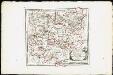
Des Herzogthums Würtemberg westsüdliche Aemter mit der freyen Reichsstadt Reutlingen : Nro. 188
Reilly, Franz Johann Joseph von
Tubingen
1 : 200000 Herder, Benjamin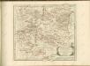

Suevia Universa :
1 : 170000 Mollova mapová sbírka Michal, Jacques de Seutter, Matthäus Seutter, Matthäus
March. Badensis pars, duc. septentrio Wurtenbergici pars
Bádensko (Německo)
Des Herzogthums Würtemberg westsüdliche Aemter mit der freyen Reichsstadt Reutlingen
1 Karte : Kupferdruck ; 23 x 26 cm Reilly F. J. J. von Reilly
Carte topographique d'Allemagne
1 : 218000 Alsasko (Francie) Jaeger, Johann Wilhelm Abraham Facius, Johann Gottlieb chez I.W.A. Iaeger