Maps of Haigerloch

Hohenzollern Hechingische Forst-Carte welche Occasione derer in solchem Territorio Ao. 1733 enstandenen Unruhe
1 : 50000 Mollova mapová sbírka Freusberg, Marquard Rudolph von
Meßtischblatt [7619] : Hechingen (Preuß.) Bodelshausen (Württ.), 1910
1 : 250000 Hechingen (Preuß.) Bodelshausen (Württ.). - 1:25000. - Stuttgart, 1910. - 1 Kt.
Meßtischblatt [7519] : Rottenburg (Württ.). Bietenhausen (Preuß.), 1909
1 : 250000 Rottenburg (Württ.). Bietenhausen (Preuß.). - 1:25000. - Stuttgart, 1909. - 1 Kt.
Meßtischblatt [7719] : Balingen (Württ.). Thanheim (Preuß.), 1911
1 : 250000 Balingen (Württ.). Thanheim (Preuß.). - 1:25000. - Stuttgart, 1911. - 1 Kt.
Geographica Provinciarum Sveviae Descriptio =
Mollova mapová sbírka Hurter, Johann Christoph Bodenehr, Johann Georg
Geographica Provinciarum Sveviae Descriptio =
Mollova mapová sbírka Hurter, Johann Christoph Bodenehr, Gabriel
Le Flambeau de la Guerre Allumee au Rhin
Mollova mapová sbírka Delisle, Guillaume Schenk, Peter II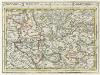
Tübingen mit dero Gegend auf 2 Stud etc.
1 : 150000 Mollova mapová sbírka Bodenehr, Gabriel Bodenehr, Gabriel
Meßtischblatt [7419] : Herrenberg, 1901
1 : 250000 Herrenberg. - 1:25000. - Stuttgart, 1901. - 1 Kt.
Meßtischblatt [7618] : Haigerloch (Preuß.) Binsdorf (Württ.), 1910
1 : 250000 Haigerloch (Preuß.) Binsdorf (Württ.). - 1:25000. - Stuttgart, 1910. - 1 Kt.
Meßtischblatt [7518] : Horb (Württ.). Imnau (Preuß.), 1909
1 : 250000 Horb (Württ.). Imnau (Preuß.). - 1:25000. - Stuttgart, 1909. - 1 Kt.
Meßtischblatt [7718] : Geislingen am Riedbach, 1911
1 : 250000 Geislingen am Riedbach. - 1:25000. - Stuttgart, 1911. - 1 Kt.
Blatt 109: Möffingen, uit: Topographische Karte von Württemberg im Massstab 1:25.000 / hrsg. vom Statistischen Landesamt
1 : 25000 titelvariant: Topographische Karte des Königreichs Württemberg im Massstabe 1:25.000; Annotatie: Titelvariant: Topographische Karte des Königreichs Württemberg im Massstabe 1:25.000; Incompleet (4 bl. aanwezig) Württembergisches Statistisches Landesamt [Stuttgart : Statistisches Landesamt]
Meßtischblatt [7620] : Talheim (Württ.). Jungingen (Preuß.), 1910
1 : 250000 Talheim (Württ.). Jungingen (Preuß.). - 1:25000. - Stuttgart, 1910. - 1 Kt.
Meßtischblatt [7520] : Mössingen, 1911
1 : 250000 Mössingen. - 1:25000. - Stuttgart, 1911. - 1 Kt.
Meßtischblatt [7720] : Ebingen (Württ.). Burladingen (Preuß.), 1910
1 : 250000 Ebingen (Württ.). Burladingen (Preuß.). - 1:25000. - Stuttgart, 1910. - 1 Kt.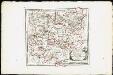
Des Herzogthums Würtemberg westsüdliche Aemter mit der freyen Reichsstadt Reutlingen : Nro. 188
Reilly, Franz Johann Joseph von
Tubingen
1 : 200000 Herder, Benjamin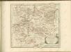

March. Badensis pars, duc. septentrio Wurtenbergici pars
Bádensko (Německo)
Des Herzogthums Würtemberg westsüdliche Aemter mit der freyen Reichsstadt Reutlingen
1 Karte : Kupferdruck ; 23 x 26 cm Reilly F. J. J. von Reilly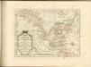

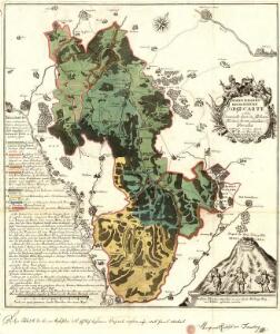
Nordwestlicher Abhang der Schwäbischen Alp
Geologischer Atlas zur Naturgeschichte der Erde Leonhard, Carl Cäsar von E. Schweizerbart'sche Verlagsbuchhandlung
178. Sigmaringen, uit: Topographische Uebersichtskarte des Deutschen Reiches / herausgegeben v. d. Kartogr. Abt. d. Königl. Preuß. Landesaufnahme
1 : 200000 titelvariant: Topogr. Übersichtskarte des Deutschen Reiches; Annotatie: Titel boven bladen ook: Topogr. Übersichtskarte des Deutschen Reiches; Annotatie geografische gegevens: Op elk blad twee maatstokken: 10 Kilometer = 5,5 cm; 1 geogr. Meile = 3,6 cm; Legenda onder op elk blad Königlich Preußische Landesaufnahme. Kartographische Abtheilung [S.l : Königlich Preußische Landesaufnahme, Kartographische Abtheilung]
Suevia Universa :
1 : 170000 Mollova mapová sbírka Michal, Jacques de Seutter, Matthäus Seutter, Matthäus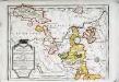
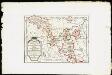
Das Fürstenthum Hohenzollern und die Grafschaft Sigmaringen
1 Karte : Kupferdruck ; 19 x 27 cm Reilly F. J. J. von Reilly
Freiburg 141, uit: Special-Karte von Mittel-Europa / nach amtlichen Quellen bearbeitet von W. Liebenow
1 : 300000 titelvariant: W. Liebenow's Mittel-Europa; Annotatie: Titel boven de bladen: W. Liebenow's Mittel-Europa Johannes Wilhelm Liebenow 1822-1897 Frankfurt a. M. : Ludwig Ravenstein
Freiburg 141, uit: [W. Liebenow's Special-Karte von Mittel-Europa]
1 : 300000 titelvariant: W. Liebenow's Mittel-Europa; Annotatie: Titel boven de bladen: W. Liebenow's Mittel-Europa Johannes Wilhelm Liebenow 1822-1897 Hannover : Hermann Oppermann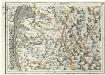
Geographica Provinciarum Sveviae Descriptio =
Mollova mapová sbírka Hurter, Johann Christoph Bodenehr, Gabriel