Maps of Landkreis Freudenstadt

Meßtischblatt [7518] : Horb (Württ.). Imnau (Preuß.), 1909
1 : 250000 Horb (Württ.). Imnau (Preuß.). - 1:25000. - Stuttgart, 1909. - 1 Kt.
Le Flambeau de la Guerre Allumee au Rhin
Mollova mapová sbírka Delisle, Guillaume Schenk, Peter II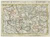
Tübingen mit dero Gegend auf 2 Stud etc.
1 : 150000 Mollova mapová sbírka Bodenehr, Gabriel Bodenehr, Gabriel
Hohenzollern Hechingische Forst-Carte welche Occasione derer in solchem Territorio Ao. 1733 enstandenen Unruhe
1 : 50000 Mollova mapová sbírka Freusberg, Marquard Rudolph von
Geographica Provinciarum Sveviae Descriptio =
Mollova mapová sbírka Hurter, Johann Christoph Bodenehr, Johann Georg
Geographica Provinciarum Sveviae Descriptio =
Mollova mapová sbírka Hurter, Johann Christoph Bodenehr, Gabriel
178. Sigmaringen, uit: Topographische Uebersichtskarte des Deutschen Reiches / herausgegeben v. d. Kartogr. Abt. d. Königl. Preuß. Landesaufnahme
1 : 200000 titelvariant: Topogr. Übersichtskarte des Deutschen Reiches; Annotatie: Titel boven bladen ook: Topogr. Übersichtskarte des Deutschen Reiches; Annotatie geografische gegevens: Op elk blad twee maatstokken: 10 Kilometer = 5,5 cm; 1 geogr. Meile = 3,6 cm; Legenda onder op elk blad Königlich Preußische Landesaufnahme. Kartographische Abtheilung [S.l : Königlich Preußische Landesaufnahme, Kartographische Abtheilung]
Suevia Universa :
1 : 170000 Mollova mapová sbírka Michal, Jacques de Seutter, Matthäus Seutter, Matthäus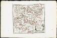
Des Herzogthums Würtemberg westsüdliche Aemter mit der freyen Reichsstadt Reutlingen : Nro. 188
Reilly, Franz Johann Joseph von
Tubingen
1 : 200000 Herder, Benjamin

Die untere Markgrafschaft Baaden oder die Grafschaft Eberstein mit den Durlachischen Landen
1 Karte : Kupferdruck ; 18 x 24 cm Reilly F. J. J. von Reilly
March. Badensis pars, duc. septentrio Wurtenbergici pars
Bádensko (Německo)
Kriegs-Theatrum.
Mollova mapová sbírka Lidl, Johann Jakob Lidl, Johann Jacob
Des Herzogthums Würtemberg westsüdliche Aemter mit der freyen Reichsstadt Reutlingen
1 Karte : Kupferdruck ; 23 x 26 cm Reilly F. J. J. von Reilly
Die Landgrafschaft Nellenburg die Landvogtey Altorf die Grafschaft Hohenberg und die kleinern durch das östreichische Schwaben zerstreuten Besitzungen mit der Stadt Kostanz und den vier Donaustaedten : Nro. 153
Reilly, Franz Johann Joseph von

Le Theatre de Bellone :
Mollova mapová sbírka Schenk, Pieter Braakman, Adriaan
Carte topographique d'Allemagne
1 : 218000 Alsasko (Francie) Jaeger, Johann Wilhelm Abraham Facius, Johann Gottlieb chez I.W.A. Iaeger
Carte topographique d'Allemagne
1 : 218000 Alsasko (Francie) Jaeger, Johann Wilhelm Abraham I. W. A. Iaeger
Nova et accuratißima Ducatus Wurtenbergici
1 : 300000 Mollova mapová sbírka Seutter, Matthäus Seutter, Matthäus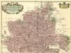
Carte tres Particuliere du Duché de Wirtemberg
1 : 240000 Mollova mapová sbírka Fer, Nicolas de Loon, Herman van L'Isle, Guillaume de
Generalkarte von Württemberg: Blatt III
1 : 1500000 Terrainzeichnung: Bach, Topograf und Hauptmann Lithografie: Rebmann und Sommer Herausgeber: K. statistisch-topografisches Büro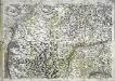
Geographica provinciarum Sueviae descriptio, 3
4 Blätter : Johann Georg Bodenehr
Les frontieres de Lorraine ou sont Espinal S'Diey, Luneville Marsal Vic La Basse Alsace divisée en balliages et seigneuries deça et de la le Rhin ou sont le Grand Balliage dHaugenau, les terres d'Hanau, de l'evesché de la ville de Strasbourg et des nobles les sources de rivieres de la Seille de la Sare de la Meurte et de la Mosele [l]es montagnes noires Sep.les lortnaw le grand marquisat de Bade et partie du Wirtenberg levé sur les lieux pendant les guerres
1 : 200000 Alsasko (Francie) Sengre, Henri Jaillot, Alexis-Hubert Iaillot
Die untere Markgrafschaft Baaden oder die Grafschaft Eberstein mit den Durlachischen Landen : Nro. 192
Reilly, Franz Johann Joseph von
Suevia universa IX. tabulis delineata, 4
1 Blatt : s.n.
Militair Karte von Süd-Deutschland in 20 Sectionen
1 : 400000 9. Section Coulon, Alois von A. von Coulon
Le Cours du Rhin au dessus de Strasbourg, les Pais adjacens.
1 : 256000 L'Isle, Guillaume de, 1675-1726
![Meßtischblatt [7518] : Horb (Württ.). Imnau (Preuß.), 1909](https://images-2.georeferencer.com/images/iiif/241582160176/full/,300/0/native.jpg)

