Maps of Zollernalbkreis

Meßtischblatt [7619] : Hechingen (Preuß.) Bodelshausen (Württ.), 1910
1 : 250000 Hechingen (Preuß.) Bodelshausen (Württ.). - 1:25000. - Stuttgart, 1910. - 1 Kt.
Hohenzollern Hechingische Forst-Carte welche Occasione derer in solchem Territorio Ao. 1733 enstandenen Unruhe
1 : 50000 Mollova mapová sbírka Freusberg, Marquard Rudolph von
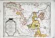
Le Flambeau de la Guerre Allumee au Rhin
Mollova mapová sbírka Delisle, Guillaume Schenk, Peter II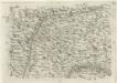
Geographica Provinciarum Sveviae Descriptio =
Mollova mapová sbírka Hurter, Johann Christoph Bodenehr, Johann Georg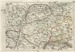
Geographica Provinciarum Sveviae Descriptio =
Mollova mapová sbírka Hurter, Johann Christoph Bodenehr, Gabriel
178. Sigmaringen, uit: Topographische Uebersichtskarte des Deutschen Reiches / herausgegeben v. d. Kartogr. Abt. d. Königl. Preuß. Landesaufnahme
1 : 200000 titelvariant: Topogr. Übersichtskarte des Deutschen Reiches; Annotatie: Titel boven bladen ook: Topogr. Übersichtskarte des Deutschen Reiches; Annotatie geografische gegevens: Op elk blad twee maatstokken: 10 Kilometer = 5,5 cm; 1 geogr. Meile = 3,6 cm; Legenda onder op elk blad Königlich Preußische Landesaufnahme. Kartographische Abtheilung [S.l : Königlich Preußische Landesaufnahme, Kartographische Abtheilung]
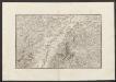
Nordwestlicher Abhang der Schwäbischen Alp
Geologischer Atlas zur Naturgeschichte der Erde Leonhard, Carl Cäsar von E. Schweizerbart'sche Verlagsbuchhandlung
Suevia Universa :
1 : 170000 Mollova mapová sbírka Michal, Jacques de Seutter, Matthäus Seutter, Matthäus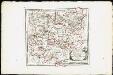
Des Herzogthums Würtemberg westsüdliche Aemter mit der freyen Reichsstadt Reutlingen : Nro. 188
Reilly, Franz Johann Joseph von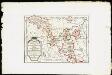
Das Fürstenthum Hohenzollern und die Grafschaft Sigmaringen mit der gefürsteten Abtey Buchau, der Deutschen Ordens Komthurey Alschhausen, der Herrschaft Justingen, den Abteÿen um den Federsee ...
Reilly, Franz Johann Joseph von
Tubingen
1 : 200000 Herder, Benjamin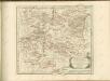
Das Fürstenthum Hohenzollern und die Grafschaft Sigmaringen
1 Karte : Kupferdruck ; 19 x 27 cm Reilly F. J. J. von Reilly
Freiburg 141, uit: [W. Liebenow's Special-Karte von Mittel-Europa]
1 : 300000 titelvariant: W. Liebenow's Mittel-Europa; Annotatie: Titel boven de bladen: W. Liebenow's Mittel-Europa Johannes Wilhelm Liebenow 1822-1897 Hannover : Hermann Oppermann
Freiburg 141, uit: Special-Karte von Mittel-Europa / nach amtlichen Quellen bearbeitet von W. Liebenow
1 : 300000 titelvariant: W. Liebenow's Mittel-Europa; Annotatie: Titel boven de bladen: W. Liebenow's Mittel-Europa Johannes Wilhelm Liebenow 1822-1897 Frankfurt a. M. : Ludwig Ravenstein
March. Badensis pars, duc. septentrio Wurtenbergici pars
Bádensko (Německo)
Des Herzogthums Würtemberg westsüdliche Aemter mit der freyen Reichsstadt Reutlingen
1 Karte : Kupferdruck ; 23 x 26 cm Reilly F. J. J. von Reilly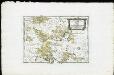
Die Landgrafschaft Nellenburg die Landvogtey Altorf die Grafschaft Hohenberg und die kleinern durch das östreichische Schwaben zerstreuten Besitzungen mit der Stadt Kostanz und den vier Donaustaedten : Nro. 153
Reilly, Franz Johann Joseph von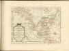

Le Theatre de Bellone :
Mollova mapová sbírka Schenk, Pieter Braakman, Adriaan
Carte topographique d'Allemagne
1 : 218000 Alsasko (Francie) Jaeger, Johann Wilhelm Abraham Facius, Johann Gottlieb chez I.W.A. Iaeger
Carte topographique d'Allemagne
1 : 218000 Alsasko (Francie) Jaeger, Johann Wilhelm Abraham I. W. A. Iaeger
Generalkarte von Württemberg: Blatt III
1 : 1500000 Terrainzeichnung: Bach, Topograf und Hauptmann Lithografie: Rebmann und Sommer Herausgeber: K. statistisch-topografisches Büro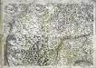
Geographica provinciarum Sueviae descriptio, 3
4 Blätter : Johann Georg Bodenehr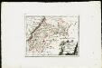
Die untere Markgrafschaft Baaden oder die Grafschaft Eberstein mit den Durlachischen Landen : Nro. 192
Reilly, Franz Johann Joseph von
Suevia universa IX. tabulis delineata, 4
1 Blatt : s.n.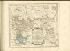
Militair Karte von Süd-Deutschland in 20 Sectionen
1 : 400000 9. Section Coulon, Alois von A. von Coulon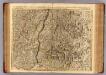
Le Cours du Rhin au dessus de Strasbourg, les Pais adjacens.
1 : 256000 L'Isle, Guillaume de, 1675-1726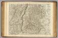
![Meßtischblatt [7619] : Hechingen (Preuß.) Bodelshausen (Württ.), 1910](https://images-2.georeferencer.com/images/iiif/043234446352/full/,300/0/native.jpg)

