Maps of Region Nordschwarzwald

Maps of Region Nordschwarzwald

$title$

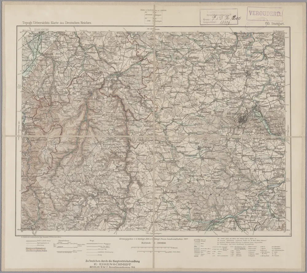
170. Stuttgart, uit: Topographische Uebersichtskarte des Deutschen Reiches / herausgegeben v. d. Kartogr. Abt. d. Königl. Preuß. Landesaufnahme

1 : 200000 titelvariant: Topogr. Übersichtskarte des Deutschen Reiches; Annotatie: Titel boven bladen ook: Topogr. Übersichtskarte des Deutschen Reiches; Annotatie geografische gegevens: Op elk blad twee maatstokken: 10 Kilometer = 5,5 cm; 1 geogr. Meile = 3,6 cm; Legenda onder op elk blad Königlich Preußische Landesaufnahme. Kartographische Abtheilung [S.l : Königlich Preußische Landesaufnahme, Kartographische Abtheilung]
$title$

Geographica Provinciarum Sveviae Descriptio =

Mollova mapová sbírka Hurter, Johann Christoph Bodenehr, Johann Georg
$title$

$title$

Geographica Provinciarum Sveviae Descriptio =

Mollova mapová sbírka Hurter, Johann Christoph Bodenehr, Gabriel
$title$

Des Herzogthums Würtemberg nordwestliche Aemter mit der freyen Reichsstadt Weil : Nro. 187

Reilly, Franz Johann Joseph von
$title$

Le Flambeau de la Guerre Allumee au Rhin

Mollova mapová sbírka Delisle, Guillaume Schenk, Peter II
$title$

Karte der Umgegend von Stuttgart

1 : 70000 Stuttgart-oblast (Německo) Hoffmann, Carl Carl Hoffmann
$title$

Stutgart, mit dero Gegend auf 2 Stund.

1 : 150000 Mollova mapová sbírka Bodenehr, Gabriel H., R.
$title$

Tübingen mit dero Gegend auf 2 Stud etc.

1 : 150000 Mollova mapová sbírka Bodenehr, Gabriel Bodenehr, Gabriel
$title$

Carte von der Innondation von Ettlingen biss zu dem Kislauer Schlosse

1 Karte auf 2 Blatt : Kupferdruck ; 23 x 94 cm Riecke; Bodenehr
$title$

Meßtischblatt [7421] : Metzingen,1901

1 : 250000 Metzingen. - 1:25000. - Stuttgart, 1901. - 1 Kt.
$title$

Meßtischblatt [7420] : Tübingen, 1901

1 : 250000 Tübingen. - 1:25000. - Stuttgart, 1901. - 1 Kt.
$title$

Meßtischblatt [7419] : Herrenberg, 1901

1 : 250000 Herrenberg. - 1:25000. - Stuttgart, 1901. - 1 Kt.
$title$

Meßtischblatt [7418] : Nagold, 1931

1 : 250000 Nagold. - 1:25000. - Stuttgart, 1931. - 1 Kt.
$title$

Meßtischblatt [7417] : Altensteig, 1931

1 : 250000 Altensteig. - 1:25000. - Stuttgart, 1931. - 1 Kt.
$title$

Meßtischblatt [7416] : Baiersbronn, 1907

1 : 250000 Baiersbronn. - 1:25000. - Stuttgart, 1907. - 1 Kt.
$title$

Meßtischblatt [7416] : Baiersbronn, 1899

1 : 250000 Baiersbronn. - 1:25000. - Stuttgart, 1899. - 1 Kt.
$title$

Meßtischblatt [7321] : Neuhausen auf den Fildern, 1899

1 : 250000 Neuhausen auf den Fildern. - 1:25000. - Stuttgart, 1899. - 1 Kt.
$title$

Meßtischblatt [7320] : Böblingen, 1900

1 : 250000 Böblingen. - 1:25000. - Stuttgart, 1900. - 1 Kt.
$title$

Meßtischblatt [7319] : Aidlingen, 1898

1 : 250000 Aidlingen. - 1:25000. - Stuttgart, 1898. - 1 Kt.
$title$

Meßtischblatt [7318] : Stammheim, 1930

1 : 250000 Stammheim. - 1:25000. - Stuttgart, 1930. - 1 Kt.
$title$

Meßtischblatt [7317] : Simmersfeld, 1894

1 : 250000 Simmersfeld. - 1:25000. - Stuttgart, 1894. - 1 Kt.
$title$

Meßtischblatt [7316] : Enzklösterle, 1899

1 : 250000 Enzklösterle. - 1:25000. - Stuttgart, 1899. - 1 Kt.
$title$

Meßtischblatt [7221] : Stuttgart, 1930

1 : 250000 Stuttgart. - 2. Ausg. - 1:25000. - Stuttgart, 1930. - 1 Kt.
$title$

Meßtischblatt [7220] : Möhringen, 1929

1 : 250000 Möhringen. - 2. Ausg. 1929. - 1:25000. - Stuttgart: Statistisches Landesamt, 1929. - 1 Kt.
$title$

Meßtischblatt [7220] : Möhringen, 1911

1 : 250000 Möhringen. - 1:25000. - Stuttgart, 1911. - 1 Kt.
$title$

Meßtischblatt [7220] : Möhringen, 1899

1 : 250000 Möhringen. - 1:25000. - Stuttgart, 1899. - 1 Kt.
$title$

Meßtischblatt [7219] : Weil der Stadt, 1930

1 : 250000 Weil der Stadt. - 1:25000. - Stuttgart, 1930. - 1 Kt.
$title$

Meßtischblatt [7218] : Neuhausen, 1875

1 : 250000 Neuhausen. - 1:25000. - Leipzig: Giesecke & Devrient, 1875. - 1 Kt.
$title$

Meßtischblatt 65 = [7216] : Loffenau, 1901

1 : 250000 Loffenau. - 1:25000. - Stuttgart, 1901. - 1 Kt.
© MapTiler © OpenStreetMap contributors
How does it work?
These instructions will show you how to find historical maps online.
Getting started
Type the place name in the search box to find the exact location. You can further adjust the search by zooming in and out.
Zoom
Zoom in and out with the buttons or use your mouse or touchpad natively.
Exact Area tool
Click here and draw a rectangle over the map to precisely define the search area.
Set filters
Narrow your search with advanced settings, such as Years (from/to), Fulltext, Publisher, etc.
Results
See the results of your search on the right side. You can scroll down to find more maps of this location.
?

Download OldMapsOnline Mobile