Maps of Dutchess County

Hudson River and Vicinity
Disturnell, John
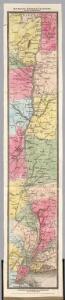
An improved map of the Hudson River : with the post roads between N. York & Albany / drawn & engraved expressly for the tourist [by] W. Chapin, sc.
from Hudson River
Wade & Croome's panorama of the Hudson River from New York to Albany
from Hudson River
An improved map of the Hudson River : with the post roads between N. York & Albany / drawn & engraved expressly for the tourist [by] W. Chapin, sc.
From Hudson River
Map of the counties of Dutchess and Putnam / by David H. Burr ; engd. by Rawdon, Clark & Co., Albany, & Rawdon, Wright & Co., New York.
from An atlas of the state of New York, designed for the use of engineers, containing a map of the state and of the several counties. / Projected and drawn ... under the superintendence and direction of Simeon de Witt.
N.Y., Kings, Queens, Richmond, Rockland, Westchester, Putnam counties.
1 : 158400 Bien, Joseph Rudolf
New York State, Double Page Plate No. 12 [Map of Albany, Rensselaer and Columbia Counties]
From Atlas of the State of New York
Map of the counties of Dutchess and Putnam / by David H. Burr ; engd. by Rawdon, Clark & Co., Albany, & Rawdon, Wright & Co., N.Y.
from (A-Z)
Map of the counties of Dutchess and Putnam / by David H. Burr ; engd. by Rawdon, Clark & Co., Albany, & Rawdon, Wright & Co., New York.
from An atlas of the state of New York : containing a map of the state and of the several counties / by David H. Burr.
A prospective plan of the battle fought near Lake George on the 8th of September, 1755 between 2000 English with 250 Mohawks under the command of General Johnson and 2500 French and Indians under the command of General Dieskau ...
Blodget, Samuel
Map of the counties of Albany and Schenectady / by David H. Burr ; engd. by Rawdon, Clark & Co., Albany, & Rawdon, Wright & Co., N.Y.
from An atlas of the state of New York, designed for the use of engineers, containing a map of the state and of the several counties. / Projected and drawn ... under the superintendence and direction of Simeon de Witt.
Albany, Rensselaer, Columbia counties.
1 : 158400 Bien, Joseph Rudolf
Map of the counties of Albany and Schenectady / by David H. Burr ; engd. by Rawdon, Clark & Co., Albany, & Rawdon, Wright & Co., N.Y.
from An atlas of the state of New York : containing a map of the state and of the several counties. / Projected and drawn under the superintendence and direction of Simeon de Witt ... And also the physical geography of the State ...
196. New York, Washington D.C.. The World Atlas.
1 : 250000 USSR (Union of Soviet Socialist Republics).
Cortlandt Manor map : prepared expressly for this work / copied for Piere Van Cortlandt esqr., June 1774, by G. Baneker.
from Cities and towns, A-Z
Map of the county of Westchester / by David H. Burr ; engd. by Rawdon, Clark & Co., Albany, & Rawdon, Wright & Co., New York.
from An atlas of the state of New York : containing a map of the state and of the several counties. / Projected and drawn under the superintendence and direction of Simeon de Witt ... And also the physical geography of the State ...
Westchester, Plate No. 1 [Map of Westchester County and Surroundings] / prepared under the direction of Joseph R. Bien, from general surveys and official records.
From Atlas of Westchester County, New York
Map of Long Island with the environs of New-York and the southern part of Connecticut / compiled from various surveys & documents by J. Calvin Smith ; engraved & printed by S. Stiles & Co., N. York.
From Long Island
Map of the counties of Dutchess and Putnam / by David H. Burr ; engd. by Rawdon, Clark & Co., Albany, & Rawdon, Wright & Co., New York.
from An atlas of the state of New York : containing a map of the state and of the several counties. / Projected and drawn under the superintendence and direction of Simeon de Witt ... And also the physical geography of the State ...
Chief Engineer's Office. Board of Estimate and Apportionment. Index Map. Showing Location of the Sectional Plans of the City of New York.
from Height district map / City of New York, Board of Estimate and Apportionment.
Schoharie County.
from Atlas of New York.
[Dutchess County].
from New York Atlas.
Plan of the encampment and position of the army under His Excelly. Lt. General Burgoyne at Swords House on Hudson's River near Stillwater on Septr. 17th : with the positions of that part of the army engaged on the 19th Septr. 1777 / drawn by W. C. Wilkin
from Revolutionary War
Map of the county of Columbia / by David H. Burr ; engd. by Rawdon, Clark & Co., Albany, & Rawdon, Wright & Co., New York.
from An atlas of the state of New York, designed for the use of engineers, containing a map of the state and of the several counties. / Projected and drawn ... under the superintendence and direction of Simeon de Witt.
A sketch of the operations of His Majesty's fleet and army : under the command of Vice Admiral the Rt. Hble. Lord Viscount Howe and Genl. Sr. Wm. Howe, K.B., in 1776.
from Revolutionary War, 1775-1783
[Columbia County].
from New York Atlas.
Map of the county of Rensselaer / by David H. Burr ; engd. by Rawdon, Clark & Co., Albany, & Rawdon, Wright & Co., New York.
from An atlas of the state of New York, designed for the use of engineers, containing a map of the state and of the several counties. / Projected and drawn ... under the superintendence and direction of Simeon de Witt.
Thirty miles round the city of New York
from Whole
Map of the county of Saratoga / by David H. Burr ; engd. by Rawdon, Clark & Co., Albany, & Rawdon, Wright & Co., N. York.
from An atlas of the state of New York : containing a map of the state and of the several counties. / Projected and drawn under the superintendence and direction of Simeon de Witt ... And also the physical geography of the State ...