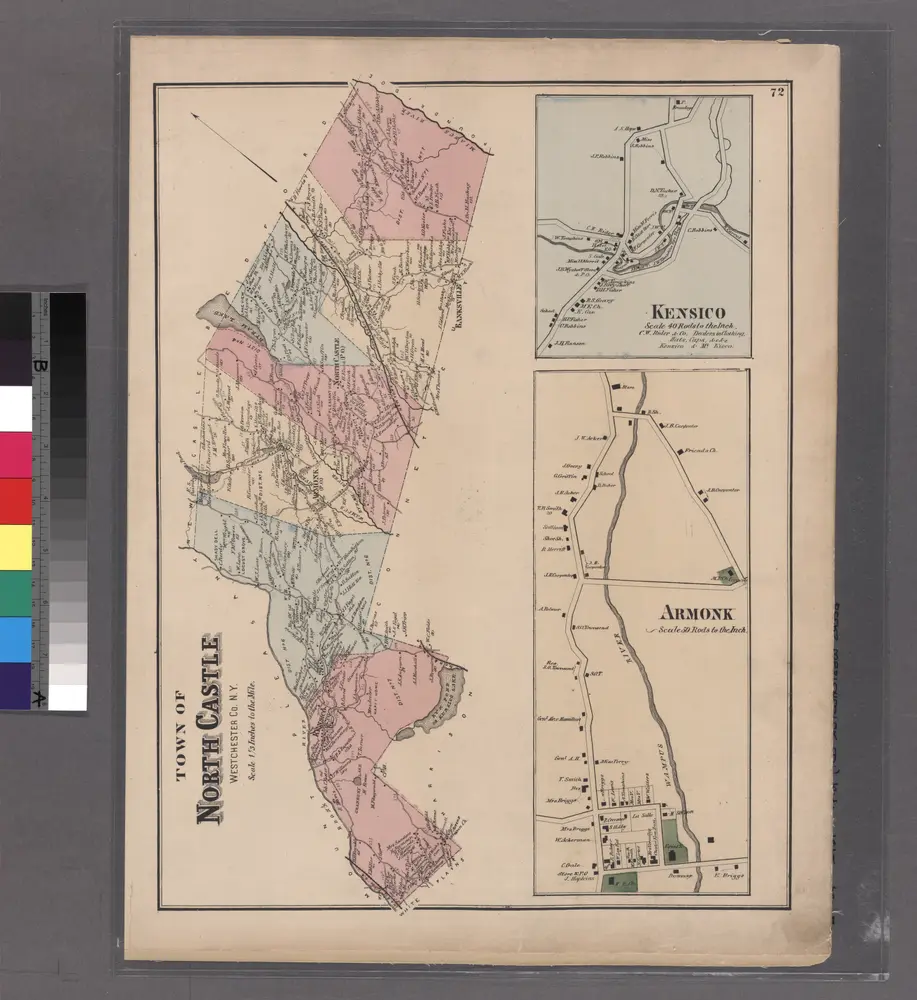
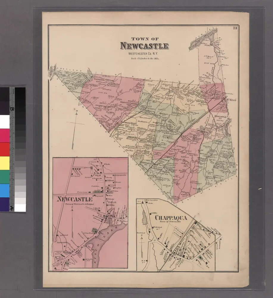
Maps of Westchester County

Maps of Westchester County

$title$

Cortlandt Manor map : prepared expressly for this work / copied for Piere Van Cortlandt esqr., June 1774, by G. Baneker.

from Cities and towns, A-Z
$title$

N.Y., Kings, Queens, Richmond, Rockland, Westchester, Putnam counties.

1 : 158400 Bien, Joseph Rudolf
$title$

Map of the county of Westchester / by David H. Burr ; engd. by Rawdon, Clark & Co., Albany, & Rawdon, Wright & Co., New York.

from An atlas of the state of New York : containing a map of the state and of the several counties. / Projected and drawn under the superintendence and direction of Simeon de Witt ... And also the physical geography of the State ...
$title$

196. New York, Washington D.C.. The World Atlas.

1 : 250000 USSR (Union of Soviet Socialist Republics).
$title$

Map of enlarged city of Brooklyn, from official records and surveys.

From Brooklyn
$title$

Westchester Co. & surroundings.

1 : 253440 Bien, Joseph Rudolf
$title$

Map Exhibiting The ... Lines for the New-York and New-Haven Rail-Road.

1 : 40000 Anderson, P.
$title$

Map Exhibiting The ... Lines for the New-York and New-Haven Rail-Road.

1 : 20000 Anderson, P.
$title$

Map of the Hudson ... from Tarrytown to Dunderbergh.

from Map of the Hudson between Sandy Hook & Sandy Hill : with the post road between New York and Albany / Bridges delt. ; Rollinson sct.
$title$

[A chart of New York Island & North River, East River, passage through Hell Gate, Flushing Bay, Hampstead Bay, Oyster Bay, Huntington Bay, Cow Harbour, East Chester Inlet, Rochelle, Rye, Patrick Islands, &c.]

from Charts and maps
$title$

Westchester County.

1 : 151000 Burr, David H., 1803-1875
$title$

Greater New York's census districts, 1920 : compiled from map prepared 1915-1918 for the 1920 census by the New York Federation of Churches.

From Manhattan
$title$

A plan of the operations of the King's army under the command of General Sr. William Howe, K.B. in New York and east New Jersey against the American forces commanded by General Washington from the 12th. of October, to the 28th. of November 1776 ...

1 : 88000 Sauthier, Claude Joseph Stedman, Charles
$title$

[Rockland County].

from Atlas of New York.
$title$

The Hudson by daylight map, from New York Bay to the head of tide water : containing names of streams, islands, and heights of mountains according to the latest coast survey : also the names of prominent residences, historic land marks, the old reaches o

from Hudson River
$title$

Outline map Westchester Co., N.Y.

1 : 109000 Bromley, George Washington; Bromley, Walter Scott; G.W. Bromley & Co.
$title$

Birds Eye View Map Of New York And Vicinity.

1 : 80033 Hammond, C.S.
$title$

Shell Metropolitan New York and Long Island. Eastern Long Island.

1 : 126720 Shell Oil Company
$title$

New map of Kings and Queens counties : from actual Surveys.

From Brooklyn
$title$

New York Island, Part of Long Island .

1 : 100000 Marshall, John
$title$

Hammods Atlas of New York City and the metropolitan district

$title$

N.Y.-Norwalk Is.

1 : 80000 United States Coast Survey
$title$

Long Island West

1 : 100000
$title$

Long Island West

1 : 100000
$title$

Map of Westchester Co.

1 : 45000 G.W. Bromley & Co.
$title$

Colton's driving & wheeling map of the country twenty five miles north of the city of New York.

1 : 73000 G.W. & C.B. Colton & Co.
$title$

New York City and Vicinity.

1 : 30000 Walling, H. F.
$title$

Panorama of the Borough of the Bronx issued by the Bronx Home News.

From Bronx
$title$

Plate 72: Town of North Castle, Westchester Co. N.Y.

from County atlas of Westchester, New York. Published by J.B. Beers & Co., assisted by S.W. Wilson and others.
$title$

Country from Frog's Point to Croton River shewing the American and British Armies 1776.

1 : 120000 Marshall, John
© MapTiler © OpenStreetMap contributors
How does it work?
These instructions will show you how to find historical maps online.
Getting started
Type the place name in the search box to find the exact location. You can further adjust the search by zooming in and out.
Zoom
Zoom in and out with the buttons or use your mouse or touchpad natively.
Exact Area tool
Click here and draw a rectangle over the map to precisely define the search area.
Set filters
Narrow your search with advanced settings, such as Years (from/to), Fulltext, Publisher, etc.
Results
See the results of your search on the right side. You can scroll down to find more maps of this location.
?

Download OldMapsOnline Mobile