Maps of Columbia County

Maps of Columbia County

$title$

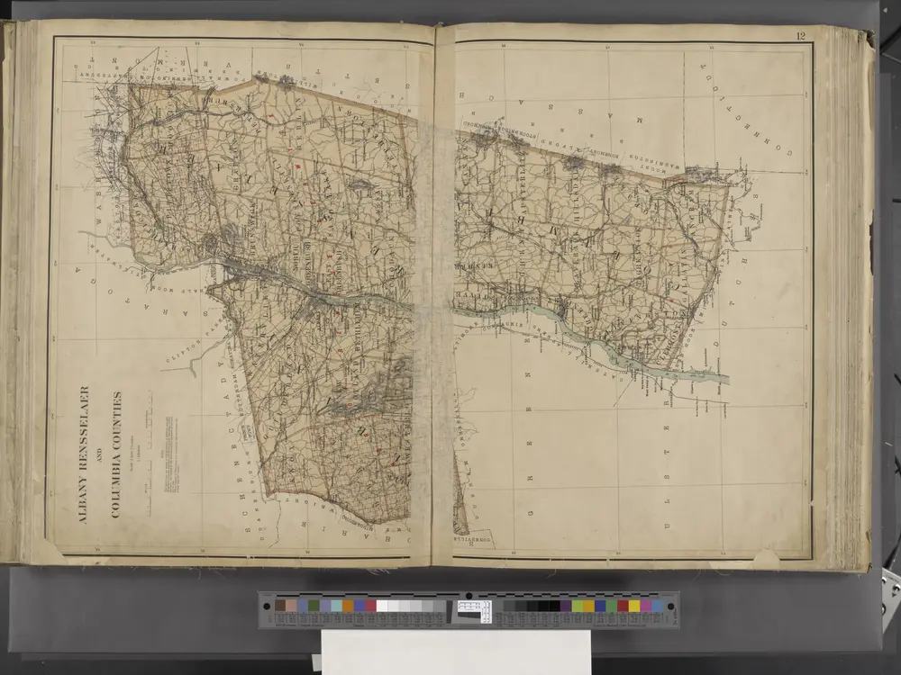
New York State, Double Page Plate No. 12 [Map of Albany, Rensselaer and Columbia Counties]

From Atlas of the State of New York
$title$

Schoharie County.

from Atlas of New York.
$title$

Plan of the encampment and position of the army under His Excelly. Lt. General Burgoyne at Swords House on Hudson's River near Stillwater on Septr. 17th : with the positions of that part of the army engaged on the 19th Septr. 1777 / drawn by W. C. Wilkin

from Revolutionary War
$title$

Albany, Rensselaer, Columbia counties.

1 : 158400 Bien, Joseph Rudolf
$title$

Map of the counties of Albany and Schenectady / by David H. Burr ; engd. by Rawdon, Clark & Co., Albany, & Rawdon, Wright & Co., N.Y.

from An atlas of the state of New York, designed for the use of engineers, containing a map of the state and of the several counties. / Projected and drawn ... under the superintendence and direction of Simeon de Witt.
$title$

Map of the county of Columbia / by David H. Burr ; engd. by Rawdon, Clark & Co., Albany, & Rawdon, Wright & Co., New York.

from An atlas of the state of New York, designed for the use of engineers, containing a map of the state and of the several counties. / Projected and drawn ... under the superintendence and direction of Simeon de Witt.
$title$

Map of Livingston Manor, 1714

from Cities and towns, A-Z
$title$

An improved map of the Hudson River : with the post roads between N. York & Albany / drawn & engraved expressly for the tourist [by] W. Chapin, sc.

From Hudson River
$title$

Map of the counties of Albany and Schenectady / by David H. Burr ; engd. by Rawdon, Clark & Co., Albany, & Rawdon, Wright & Co., N.Y.

from An atlas of the state of New York : containing a map of the state and of the several counties. / Projected and drawn under the superintendence and direction of Simeon de Witt ... And also the physical geography of the State ...
$title$

[Columbia County].

from New York Atlas.
$title$

Map of the county of Greene / by David H. Burr ; engd. by Rawdon, Clark & Co., Albany, & Rawdon, Wright & Co., New York.

from An atlas of the state of New York, designed for the use of engineers, containing a map of the state and of the several counties. / Projected and drawn ... under the superintendence and direction of Simeon de Witt.
$title$

Map of the county of Greene / by David H. Burr ; engd. by Rawdon, Clark & Co., Albany, & Rawdon, Wright & Co., New York.

from An atlas of the state of New York : containing a map of the state and of the several counties / by David H. Burr.
$title$

Columbia Co.

from Atlas of Columbia County, New York. From actual surveys and official records. Compiled & published by D. G. Beers & Co.
$title$

Map of the county of Greene / by David H. Burr ; engd. by Rawdon, Clark & Co., Albany, & Rawdon, Wright & Co., New York.

from An atlas of the state of New York : containing a map of the state and of the several counties. / Projected and drawn under the superintendence and direction of Simeon de Witt ... And also the physical geography of the State ...
$title$

Map of the county of Columbia / by David H. Burr ; engd. by Rawdon, Clark & Co., Albany, & Rawdon, Wright & Co., New York.

from An atlas of the state of New York : containing a map of the state and of the several counties. / Projected and drawn under the superintendence and direction of Simeon de Witt ... And also the physical geography of the State ...
$title$

[Schenectady County].

from New York Atlas.
$title$

Map of the county of Rensselaer / by David H. Burr ; engd. by Rawdon, Clark & Co., Albany, & Rawdon, Wright & Co., New York.

from An atlas of the state of New York, designed for the use of engineers, containing a map of the state and of the several counties. / Projected and drawn ... under the superintendence and direction of Simeon de Witt.
$title$

Map of Albany County.

from New topographical atlas of the counties of Albany and Schenectady, New York : from actual surveys / by S.N. & D.G. Beers and assistants.
$title$

Fulton, Montgomery, Schenectady, Schoharie, Greene counties.

1 : 158400 Bien, Joseph Rudolf
$title$

Map of the County of Rensselaer / by David H. Burr ; engd. by Rawdon, Clark & Co., Albany, & Rawdon, Wright & Co., New York.

from An atlas of the state of New York : containing a map of the state and of the several counties. / Projected and drawn under the superintendence and direction of Simeon de Witt ... And also the physical geography of the State ...
$title$

Railway and highway map of the famous Berkshire Hills region, showing also villages and points of interest : from official records and other information

1 : 134376 Watson, Walter, civil engineer Struthers, Servoss & Co.
$title$

Railway and highway map of the famous Berkshire Hills region : showing also villages and points of interest : from official records and other information

1 : 134376 Watson, Walter, civil engineer Sun Printing Company
$title$

A prospective plan of the battle fought near Lake George on the 8th of September, 1755 between 2000 English with 250 Mohawks under the command of General Johnson and 2500 French and Indians under the command of General Dieskau ...

Blodget, Samuel
$title$

Map of Schenectady County

from New topographical atlas of the counties of Albany and Schenectady, New York : from actual surveys / by S.N. & D.G. Beers and assistants.
$title$

Nieuwe afteekeningh van de Noord Rivier met alle desselfs ancker plaetsen dieptens banken en klippen, geleegen in Nieuw Nederlandt [south part]

United States Gerard van Keulen
$title$

The Hudson by daylight map, from New York Bay to the head of tide water : containing names of streams, islands, and heights of mountains according to the latest coast survey : also the names of prominent residences, historic land marks, the old reaches o

from Hudson River
$title$

Map of the Hudson River Rail Road from New York to Albany / engraved by Robt. Haering, N.Y. ; W.C. Moore, del.

from Hudson River
$title$

Pittsfield

1 : 100000
$title$

Pittsfield

1 : 100000
$title$

Albany

1 : 100000
$title$

Albany

1 : 100000
$title$

Albany

1 : 100000
© MapTiler © OpenStreetMap contributors
How does it work?
These instructions will show you how to find historical maps online.
Getting started
Type the place name in the search box to find the exact location. You can further adjust the search by zooming in and out.
Zoom
Zoom in and out with the buttons or use your mouse or touchpad natively.
Exact Area tool
Click here and draw a rectangle over the map to precisely define the search area.
Set filters
Narrow your search with advanced settings, such as Years (from/to), Fulltext, Publisher, etc.
Results
See the results of your search on the right side. You can scroll down to find more maps of this location.
?

Download OldMapsOnline Mobile