Maps of Albany County

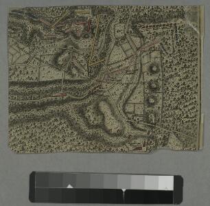
Plan of the encampment and position of the army under His Excelly. Lt. General Burgoyne at Swords House on Hudson's River near Stillwater on Septr. 17th : with the positions of that part of the army engaged on the 19th Septr. 1777 / drawn by W. C. Wilkin
from Revolutionary War
Schoharie County.
from Atlas of New York.
Map of the counties of Albany and Schenectady / by David H. Burr ; engd. by Rawdon, Clark & Co., Albany, & Rawdon, Wright & Co., N.Y.
from An atlas of the state of New York, designed for the use of engineers, containing a map of the state and of the several counties. / Projected and drawn ... under the superintendence and direction of Simeon de Witt.
Albany, Rensselaer, Columbia counties.
1 : 158400 Bien, Joseph Rudolf
Map of the counties of Albany and Schenectady / by David H. Burr ; engd. by Rawdon, Clark & Co., Albany, & Rawdon, Wright & Co., N.Y.
from An atlas of the state of New York : containing a map of the state and of the several counties. / Projected and drawn under the superintendence and direction of Simeon de Witt ... And also the physical geography of the State ...
Map of the county of Greene / by David H. Burr ; engd. by Rawdon, Clark & Co., Albany, & Rawdon, Wright & Co., New York.
from An atlas of the state of New York : containing a map of the state and of the several counties. / Projected and drawn under the superintendence and direction of Simeon de Witt ... And also the physical geography of the State ...
Map of Albany County.
from New topographical atlas of the counties of Albany and Schenectady, New York : from actual surveys / by S.N. & D.G. Beers and assistants.
[Schenectady County].
from New York Atlas.
Columbia Co.
from Atlas of Columbia County, New York. From actual surveys and official records. Compiled & published by D. G. Beers & Co.
Map of the Hudson River Rail Road from New York to Albany / engraved by Robt. Haering, N.Y. ; W.C. Moore, del.
from Hudson River
The Hudson by daylight map, from New York Bay to the head of tide water : containing names of streams, islands, and heights of mountains according to the latest coast survey : also the names of prominent residences, historic land marks, the old reaches o
from Hudson River
Albany
1 : 100000
Albany
1 : 100000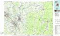
Albany
1 : 100000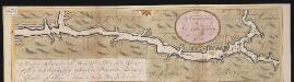
Nieuwe afteekeningh van de Noord Rivier met alle desselfs ancker plaetsen dieptens banken en klippen, geleegen in Nieuw Nederlandt [south part]
United States Gerard van Keulen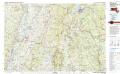
Pittsfield
1 : 100000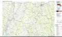
Pittsfield
1 : 100000
Rensselaer County.
1 : 151000 Burr, David H., 1803-1875
New York
1 : 2000000 Breese, S.
Albany - Troy - Schenectady and Vicinity (New York).
1 : 95040 Shell Oil Company
Hudson River & vicinity / drawn by David H. Burr ; S. Stiles & Co., N.Y.
from Hudson River
Guilderland [Township]; Hamiltonville [Village]; Hamiltonville Business Directory.; Knowersville Business Directory.; Guilderland Centre [Village]; Guilderland Centre Business Directory.
from New topographical atlas of the counties of Albany and Schenectady, New York : from actual surveys / by S.N. & D.G. Beers and assistants.
Albany and vicinity, New York / Henry Gannett, chief topographer ; H.M. Wilson, geographer in charge ; triangulation by N.Y. State Survey and by U.S. Coast and Geodetic Survey ; topography by Frank Sutton and J.H. Jennings
1 : 62500 Annotatie geografische gegevens: Opname: 1891-1892 Henry Gannett 1846-1914; Wilson, H.M.; Sutton, Frank; Jennings, J.H.; N.Y. State Survey; US Coast and Geodetic Survey [Washington, D.C. : U.S. Geological Survey]
Greene County.
1 : 151000 Burr, David H., 1803-1875
Pittsfield quadrangle, Massachusetts
1 : 62500 Geological Survey (U.S.) U.S. Geological Survey
Albany, Schenectady counties.
1 : 151000 Burr, David H., 1803-1875
Berlin quadrangle, New York
1 : 62500 Geological Survey (U.S.) U.S. Geological Survey
Watervliet [Township]; Watervliet Center [Village]; Watervliet Center Business Directory.; North Albany [Village]
from New topographical atlas of the counties of Albany and Schenectady, New York : from actual surveys / by S.N. & D.G. Beers and assistants.
Map of Schenectady County
from New topographical atlas of the counties of Albany and Schenectady, New York : from actual surveys / by S.N. & D.G. Beers and assistants.