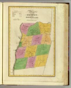
Maps of Rensselaer County

Rensselaer County.
1 : 151000 Burr, David H., 1803-1875
Albany and vicinity, New York / Henry Gannett, chief topographer ; H.M. Wilson, geographer in charge ; triangulation by N.Y. State Survey and by U.S. Coast and Geodetic Survey ; topography by Frank Sutton and J.H. Jennings
1 : 62500 Annotatie geografische gegevens: Opname: 1891-1892 Henry Gannett 1846-1914; Wilson, H.M.; Sutton, Frank; Jennings, J.H.; N.Y. State Survey; US Coast and Geodetic Survey [Washington, D.C. : U.S. Geological Survey]
Albany - Troy - Schenectady and Vicinity (New York).
1 : 95040 Shell Oil Company
Hudson River & vicinity / drawn by David H. Burr ; S. Stiles & Co., N.Y.
from Hudson River
Watervliet [Township]; Watervliet Center [Village]; Watervliet Center Business Directory.; North Albany [Village]
from New topographical atlas of the counties of Albany and Schenectady, New York : from actual surveys / by S.N. & D.G. Beers and assistants.
Berlin quadrangle, New York
1 : 62500 Geological Survey (U.S.) U.S. Geological Survey
Troy
1 : 62500
Troy
1 : 62500
Troy
1 : 62500
Troy
1 : 62500
Troy
1 : 62500
Troy
1 : 62500
Troy
1 : 48000
Troy
1 : 62500
Troy
1 : 62500
Troy
1 : 62500
Troy
1 : 62500
Troy
1 : 62500
Troy
1 : 62500
Troy
1 : 62500
Troy
1 : 62500
Troy
1 : 62500
Half Moon [Township]
from New topographical atlas of Saratoga Co., New York, from actual surveys by S. N. & D. G. Beers and assistants.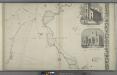
City of Troy [cont.]; St. Peters Church. ; North Second St. M.E. Church
from Map of the city of Troy, West Troy and Green Island, N.Y. : from actual surveys / by William Barton.
Portion of Albany County. ; Portion of Rensselaer County.
from Atlas of the Hudson River Valley from New York city to Troy, including a section of about 8 miles in width. Published by Watson & co. Compiled from official records and careful surveys, under the supervision of F. W. Beers.
Portion of Albany County. and City of Albany. ; Portion of Rensselaer County. and Bath and Greenbush.
from Atlas of the Hudson River Valley from New York city to Troy, including a section of about 8 miles in width. Published by Watson & co. Compiled from official records and careful surveys, under the supervision of F. W. Beers.
Half Moon, Saratoga County, New York.
1 : 42240 Beers, B.G.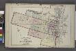
Outline and Index
from City atlas of Albany, New York : from official records, private plans and actual surveys, based upon plans deposited in the Department of Surveys.
Cohoes
1 : 62500
Cohoes
1 : 62500
Cohoes
1 : 62500
Cohoes
1 : 62500
Cohoes
1 : 62500
Cohoes
1 : 62500
Cohoes
1 : 62500
Cohoes
1 : 62500
Cohoes
1 : 62500
Cohoes
1 : 62500
Cohoes
1 : 62500
Cohoes
1 : 62500
Cohoes
1 : 62500
Cohoes
1 : 62500
Cohoes
1 : 62500
Cohoes
1 : 62500