Maps of Saratoga County

An improved map of the Hudson River : with the post roads between N. York & Albany / drawn & engraved expressly for the tourist [by] W. Chapin, sc.
from Hudson River
Hudson River and Vicinity
Disturnell, John
Wade & Croome's panorama of the Hudson River from New York to Albany
from Hudson River
An improved map of the Hudson River : with the post roads between N. York & Albany / drawn & engraved expressly for the tourist [by] W. Chapin, sc.
From Hudson River
Map of the counties of Dutchess and Putnam / by David H. Burr ; engd. by Rawdon, Clark & Co., Albany, & Rawdon, Wright & Co., N.Y.
from (A-Z)
Map of the counties of Dutchess and Putnam / by David H. Burr ; engd. by Rawdon, Clark & Co., Albany, & Rawdon, Wright & Co., New York.
from An atlas of the state of New York : containing a map of the state and of the several counties. / Projected and drawn under the superintendence and direction of Simeon de Witt ... And also the physical geography of the State ...
A prospective plan of the battle fought near Lake George on the 8th of September, 1755 between 2000 English with 250 Mohawks under the command of General Johnson and 2500 French and Indians under the command of General Dieskau ...
Blodget, Samuel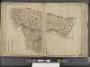
New York State, Double Page Plate No. 12 [Map of Albany, Rensselaer and Columbia Counties]
From Atlas of the State of New York
Westchester, Plate No. 1 [Map of Westchester County and Surroundings] / prepared under the direction of Joseph R. Bien, from general surveys and official records.
From Atlas of Westchester County, New York
Map of the county of Westchester / by David H. Burr ; engd. by Rawdon, Clark & Co., Albany, & Rawdon, Wright & Co., New York.
from An atlas of the state of New York : containing a map of the state and of the several counties. / Projected and drawn under the superintendence and direction of Simeon de Witt ... And also the physical geography of the State ...
Albany, Rensselaer, Columbia counties.
1 : 158400 Bien, Joseph Rudolf
Map of the counties of Dutchess and Putnam / by David H. Burr ; engd. by Rawdon, Clark & Co., Albany, & Rawdon, Wright & Co., New York.
from An atlas of the state of New York : containing a map of the state and of the several counties / by David H. Burr.
Map of the counties of Dutchess and Putnam / by David H. Burr ; engd. by Rawdon, Clark & Co., Albany, & Rawdon, Wright & Co., New York.
from An atlas of the state of New York, designed for the use of engineers, containing a map of the state and of the several counties. / Projected and drawn ... under the superintendence and direction of Simeon de Witt.
N.Y., Kings, Queens, Richmond, Rockland, Westchester, Putnam counties.
1 : 158400 Bien, Joseph Rudolf
[Dutchess County].
from New York Atlas.
Map of Long Island with the environs of New-York and the southern part of Connecticut / compiled from various surveys & documents by J. Calvin Smith ; engraved & printed by S. Stiles & Co., N. York.
From Long Island
Map of the county of Columbia / by David H. Burr ; engd. by Rawdon, Clark & Co., Albany, & Rawdon, Wright & Co., New York.
from An atlas of the state of New York, designed for the use of engineers, containing a map of the state and of the several counties. / Projected and drawn ... under the superintendence and direction of Simeon de Witt.
[Columbia County].
from New York Atlas.
Map of the county of Rensselaer / by David H. Burr ; engd. by Rawdon, Clark & Co., Albany, & Rawdon, Wright & Co., New York.
from An atlas of the state of New York, designed for the use of engineers, containing a map of the state and of the several counties. / Projected and drawn ... under the superintendence and direction of Simeon de Witt.
Map of the progress of His Majesty's armies in New York during the late campaign : illustrating the accounts publish'd in the London Gazette.
from Revolutionary War
Map of the counties of Albany and Schenectady / by David H. Burr ; engd. by Rawdon, Clark & Co., Albany, & Rawdon, Wright & Co., N.Y.
from An atlas of the state of New York, designed for the use of engineers, containing a map of the state and of the several counties. / Projected and drawn ... under the superintendence and direction of Simeon de Witt.
Thirty miles round the city of New York
from Whole
40 miles around New York
1 : 158400 H.H. Lloyd & Co
Chief Engineer's Office. Board of Estimate and Apportionment. Index Map. Showing Location of the Sectional Plans of the City of New York.
from Height district map / City of New York, Board of Estimate and Apportionment.
Map of the counties of New York, Queens, Kings, and Richmond.
from An atlas of the state of New York : containing a map of the state and of the several counties. / Projected and drawn under the superintendence and direction of Simeon de Witt ... And also the physical geography of the State ...
The country twenty five miles round New York
1 : 220000 ... W. Hawkes (successor to T. Kitchin), No. 59, Holborn Hill
Map of the county of Saratoga / by David H. Burr ; engd. by Rawdon, Clark & Co., Albany, & Rawdon, Wright & Co., N. York.
from An atlas of the state of New York, designed for the use of engineers, containing a map of the state and of the several counties. / Projected and drawn ... under the superintendence and direction of Simeon de Witt.
Thirty miles round the city of New York
from Whole
Map of Long Island with the environs of New-York and the southern part of Connecticut / compiled from various surveys & documents by J. Calvin Smith ; engraved & printed by S. Stiles & Co., N. York.
From Long Island
![An improved map of the Hudson River : with the post roads between N. York & Albany / drawn & engraved expressly for the tourist [by] W. Chapin, sc.](https://images-2.georeferencer.com/images/iiif/637174215173/full/,300/0/native.jpg)

