Maps of Westchester County

Westchester, Plate No. 1 [Map of Westchester County and Surroundings] / prepared under the direction of Joseph R. Bien, from general surveys and official records.
From Atlas of Westchester County, New York
Map of Long Island with the environs of New-York and the southern part of Connecticut / compiled from various surveys & documents by J. Calvin Smith ; engraved & printed by S. Stiles & Co., N. York.
From Long Island
Map of the progress of His Majesty's armies in New York during the late campaign : illustrating the accounts publish'd in the London Gazette.
from Revolutionary War
N.Y., Kings, Queens, Richmond, Rockland, Westchester, Putnam counties.
1 : 158400 Bien, Joseph Rudolf
Chief Engineer's Office. Board of Estimate and Apportionment. Index Map. Showing Location of the Sectional Plans of the City of New York.
from Height district map / City of New York, Board of Estimate and Apportionment.
40 miles around New York
1 : 158400 H.H. Lloyd & Co
Thirty miles round the city of New York
from Whole
Thirty three miles around the city of New-York
from Whole
Thirty miles round the city of New York
from Whole
A sketch of the operations of His Majesty's fleet and army : under the command of Vice Admiral the Rt. Hble. Lord Viscount Howe and Genl. Sr. Wm. Howe, K.B., in 1776.
from Revolutionary War, 1775-1783
Map of the country thirty miles round the city of New York
1 : 190080 Disturnell, John, 1801-1877 J. Disturnell
196. New York, Washington D.C.. The World Atlas.
1 : 250000 USSR (Union of Soviet Socialist Republics).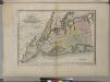
Map of the counties of New York, Queens, Kings, and Richmond.
from An atlas of the state of New York, designed for the use of engineers, containing a map of the state and of the several counties. / Projected and drawn ... under the superintendence and direction of Simeon de Witt.
Map of the counties of New York, Queens, Kings, and Richmond.
from An atlas of the state of New York : containing a map of the state and of the several counties / by David H. Burr.
Map of the county of Westchester / by David H. Burr ; engd. by Rawdon, Clark & Co., Albany, & Rawdon, Wright & Co., New York.
from An atlas of the state of New York : containing a map of the state and of the several counties. / Projected and drawn under the superintendence and direction of Simeon de Witt ... And also the physical geography of the State ...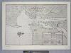
Vingboons map of Manhattan, 1639 : a facsimile from the Library of Congress.
from Whole
Map ... Around The City Of New York.
1 : 205920 Colton, J. H.
The country twenty five miles round New York
1 : 220000 ... W. Hawkes (successor to T. Kitchin), No. 59, Holborn Hill
Map of Long Island with the environs of New-York and the southern part of Connecticut / compiled from various surveys & documents by J. Calvin Smith ; engraved & printed by S. Stiles & Co., N. York.
From Long Island
Map of the counties of New York, Queens, Kings, and Richmond.
from An atlas of the state of New York : containing a map of the state and of the several counties. / Projected and drawn under the superintendence and direction of Simeon de Witt ... And also the physical geography of the State ...
Map Of The Country Thirty Miles Round the City of New York.
1 : 190080 Eddy, John H.
Cortlandt Manor map : prepared expressly for this work / copied for Piere Van Cortlandt esqr., June 1774, by G. Baneker.
from Cities and towns, A-Z
Map of the Country Twenty Five Miles Round The City Of New-York.
1 : 300000 Greenleaf, Jeremiah
Map of the Country Twenty Five Miles Round The City Of New-York.
1 : 316800 Greenleaf, Jeremiah
Map of the Hudson ... from Tarrytown to Dunderbergh.
from Map of the Hudson between Sandy Hook & Sandy Hill : with the post road between New York and Albany / Bridges delt. ; Rollinson sct.
New York and vicinity [map]
1 : 24000 Geological Survey (U.S.) Geological Survey
Westchester Co. & surroundings.
1 : 253440 Bien, Joseph Rudolf
Map of Staten Island o Richmond County. 16 views of buildings on border. Also view of Elliottville the property of Dr. S. M. Elliott.
From Staten Island
Map of the Country Twenty Five Miles Round The City Of New-York.
1 : 211200 Burr, David H., 1803-1875
![Westchester, Plate No. 1 [Map of Westchester County and Surroundings] / prepared under the direction of Joseph R. Bien, from general surveys and official records.](https://images-2.georeferencer.com/images/iiif/295603766367/full/,300/0/native.jpg)

