Maps of Dutchess County

Map of the counties of Dutchess and Putnam / by David H. Burr ; engd. by Rawdon, Clark & Co., Albany, & Rawdon, Wright & Co., N.Y.
from (A-Z)
Map of the counties of Dutchess and Putnam / by David H. Burr ; engd. by Rawdon, Clark & Co., Albany, & Rawdon, Wright & Co., New York.
from An atlas of the state of New York : containing a map of the state and of the several counties / by David H. Burr.
Map of the counties of Dutchess and Putnam / by David H. Burr ; engd. by Rawdon, Clark & Co., Albany, & Rawdon, Wright & Co., New York.
from An atlas of the state of New York, designed for the use of engineers, containing a map of the state and of the several counties. / Projected and drawn ... under the superintendence and direction of Simeon de Witt.
Map of the counties of Dutchess and Putnam / by David H. Burr ; engd. by Rawdon, Clark & Co., Albany, & Rawdon, Wright & Co., New York.
from An atlas of the state of New York : containing a map of the state and of the several counties. / Projected and drawn under the superintendence and direction of Simeon de Witt ... And also the physical geography of the State ...
[Dutchess County].
from New York Atlas.
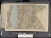
Map of the county of Westchester / by David H. Burr ; engd. by Rawdon, Clark & Co., Albany, & Rawdon, Wright & Co., New York.
from An atlas of the state of New York : containing a map of the state and of the several counties. / Projected and drawn under the superintendence and direction of Simeon de Witt ... And also the physical geography of the State ...
Map of Dutchess County, New-York from original surveys / J.C. Sidney C.E., author of 12 miles around New York.
from Counties
Map of the Hudson River Rail Road from New York to Albany / engraved by Robt. Haering, N.Y. ; W.C. Moore, del.
from Hudson River
Dutchess, Putnam counties.
1 : 151000 Burr, David H., 1803-1875
Dutchess County.
1 : 158400 Bien, Joseph Rudolf
A plan of the operations of the King's army under the command of General Sr. William Howe, K.B. in New York and east New Jersey against the American forces commanded by General Washington from the 12th. of October, to the 28th. of November 1776 ...
1 : 88000 Sauthier, Claude Joseph Stedman, Charles
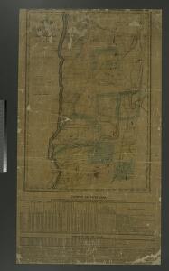
Cortlandt Manor map : prepared expressly for this work / copied for Piere Van Cortlandt esqr., June 1774, by G. Baneker.
from Cities and towns, A-Z
[Rockland County].
from Atlas of New York.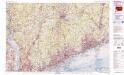
Bridgeport
1 : 100000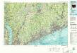
Bridgeport
1 : 100000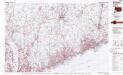
Bridgeport
1 : 100000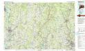
Waterbury
1 : 100000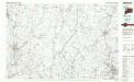
Waterbury
1 : 100000
Map of Dutchess County New York
from New illustrated atlas of Dutchess County, New York. / Compiled & drawn from personal examinations, surveys etc. under the personal supervision of O.W. Gray & Son and F.A. Davis, and published under the superintendence of H. L. Kochersperger.
Map of Dutchess County New York
from New illustrated atlas of Dutchess County, New York. / Compiled & drawn from personal examinations, surveys etc. under the personal supervision of O.W. Gray & Son and F.A. Davis, and published under the superintendence of H. L. Kochersperger.
The Hudson by daylight map, from New York Bay to the head of tide water : containing names of streams, islands, and heights of mountains according to the latest coast survey : also the names of prominent residences, historic land marks, the old reaches o
from Hudson River
Plate 72: Town of North Castle, Westchester Co. N.Y.
from County atlas of Westchester, New York. Published by J.B. Beers & Co., assisted by S.W. Wilson and others.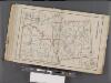
Westchester, Double Page Plate No. 30 [Map of Town of Bedford and Somers] / prepared under the direction of Joseph R. Bien, from general surveys and official records.
From Atlas of Westchester County, New York
Westchester County.
1 : 151000 Burr, David H., 1803-1875
Map of Westchester Co.
1 : 45000 G.W. Bromley & Co.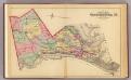
Outline map Westchester Co., N.Y.
1 : 109000 Bromley, George Washington; Bromley, Walter Scott; G.W. Bromley & Co.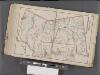
Westchester, Double Page Plate No. 31 [Map of Town of Poundridge, Lewisbord and North Salem] / prepared under the direction of Joseph R. Bien, from general surveys and official records.
From Atlas of Westchester County, New York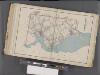
Westchester, Double Page Plate No. 25 [Map of Town of Cortlandt] / prepared under the direction of Joseph R. Bien, from general surveys and official records.
From Atlas of Westchester County, New York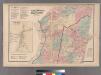
Large folder - L1
from Atlas of New York and vicinity : from actual surveys / by and under the direction of F. W. Beers, assisted by A. B. Prindle & others