Maps of Westchester County

[Rockland County].
from Atlas of New York.
Map of the Hudson ... from Tarrytown to Dunderbergh.
from Map of the Hudson between Sandy Hook & Sandy Hill : with the post road between New York and Albany / Bridges delt. ; Rollinson sct.
A plan of the operations of the King's army under the command of General Sr. William Howe, K.B. in New York and east New Jersey against the American forces commanded by General Washington from the 12th. of October, to the 28th. of November 1776 ...
1 : 88000 Sauthier, Claude Joseph Stedman, Charles
Westchester County.
1 : 151000 Burr, David H., 1803-1875
Westchester Co. & surroundings.
1 : 253440 Bien, Joseph Rudolf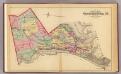
Outline map Westchester Co., N.Y.
1 : 109000 Bromley, George Washington; Bromley, Walter Scott; G.W. Bromley & Co.
Map of Westchester Co.
1 : 45000 G.W. Bromley & Co.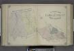
Outline Map of Passaic County, New Jersey.
from Atlas of Passaic County, New-Jersey : topographical, geological, historical, illustrated ; from actual surveys of each township and village / under the supervision of the publishers, assisted by the able engineers of Paterson.
Colton's driving & wheeling map of the country twenty five miles north of the city of New York.
1 : 73000 G.W. & C.B. Colton & Co.
Country from Frog's Point to Croton River shewing the American and British Armies 1776.
1 : 120000 Marshall, John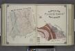
Geological Map of Passaic County, New Jersey.
from Atlas of Passaic County, New-Jersey : topographical, geological, historical, illustrated ; from actual surveys of each township and village / under the supervision of the publishers, assisted by the able engineers of Paterson.
New York City and Vicinity.
1 : 30000 Walling, H. F.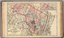
Bergen, Passaic Cos., N.J.
1 : 126720 Beers, F. W. (Frederick W.)
The Hudson by daylight map, from New York Bay to the head of tide water : containing names of streams, islands, and heights of mountains according to the latest coast survey : also the names of prominent residences, historic land marks, the old reaches o
from Hudson River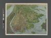
Panorama of the Borough of the Bronx issued by the Bronx Home News.
From Bronx
New Jersey, Double Page Sheet No. 7 [Map of Northeastern Red Sandstone]
From Atlas of New Jersey.
Plate 72: Town of North Castle, Westchester Co. N.Y.
from County atlas of Westchester, New York. Published by J.B. Beers & Co., assisted by S.W. Wilson and others.
7 NE red sandstone.
1 : 63360 Vermeule, C. C. (Cornelius Clarkson), 1858-1950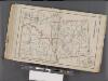
Westchester, Double Page Plate No. 30 [Map of Town of Bedford and Somers] / prepared under the direction of Joseph R. Bien, from general surveys and official records.
From Atlas of Westchester County, New York
Birds Eye View Map Of New York And Vicinity.
1 : 80033 Hammond, C.S.
Plaines Blanches et Armees Americaine et Britannique, 12 Octobre1776.
1 : 130000 Marshall, John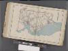
Westchester, Double Page Plate No. 25 [Map of Town of Cortlandt] / prepared under the direction of Joseph R. Bien, from general surveys and official records.
From Atlas of Westchester County, New York
A plan of the country from Frogspoint to Croton River shewing the positions of the American and British armies from the 12th of October 1776 until the engagement on the White Plains on the 28th
1 : 128400 Lewis, Samuel Wayne, Caleb Parry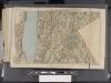
Westchester, Double Page Plate [Map of Westchester County, Irvington, Tarry Town to Sing Sing, East to State Line] / prepared under the direction of Joseph R. Bien, from general surveys and official records.
From Atlas of Westchester County, New York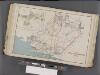
Westchester, Double Page Plate No. 17 [Map of Towns of White Plains, Harrison, and Rye] / prepared under the direction of Joseph R. Bien, from general surveys and official records.
From Atlas of Westchester County, New York
Map of the Hudson ... from Spuyten Duyvil to P. Livingston's.
from Map of the Hudson between Sandy Hook & Sandy Hill : with the post road between New York and Albany / Bridges delt. ; Rollinson sct.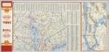
(Metropolitan New York and Long Island) Northern Section. To and Through Manhattan.
Shell Oil Company
Westchester, Plate No. 29 [Map of Town of New Castle, Village of Mt.Kisco, Village of Chappaqua] / prepared under the direction of Joseph R. Bien, from general surveys and official records.
From Atlas of Westchester County, New York
Westchester, Double Page Plate No. 13 [Map of Towns of Scarsdale, New Rochelle, and Mamaroneck] / prepared under the direction of Joseph R. Bien, from general surveys and official records.
From Atlas of Westchester County, New York
![[Rockland County].](https://images-2.georeferencer.com/images/iiif/103851830881/full/,300/0/native.jpg)

