Maps of Town of Cortlandt
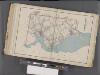
Westchester, Double Page Plate No. 25 [Map of Town of Cortlandt] / prepared under the direction of Joseph R. Bien, from general surveys and official records.
From Atlas of Westchester County, New York
Crugers Sta,. Boscobel P.O.
from County atlas of Westchester, New York. Published by J.B. Beers & Co., assisted by S.W. Wilson and others.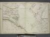
Portion of Rockland County. ; Portion of Westchester County.
from Atlas of the Hudson River Valley from New York city to Troy, including a section of about 8 miles in width. Published by Watson & co. Compiled from official records and careful surveys, under the supervision of F. W. Beers.
Westchester Co., Scarborough-Putnam Co. line.
1 : 31680 Vermeule, C. C. (Cornelius Clarkson), 1858-1950
West Point
1 : 62500
West Point
1 : 62500
West Point
1 : 62500
West Point
1 : 62500
West Point
1 : 62500
West Point
1 : 48000
West Point
1 : 62500
West Point
1 : 62500
West Point
1 : 62500
West Point
1 : 62500
West Point
1 : 62500
West Point
1 : 62500
West Point
1 : 62500
West Point
1 : 62500
West Point
1 : 62500
West Point
1 : 62500
West Point
1 : 62500
West Point
1 : 62500
West Point
1 : 62500
West Point
1 : 62500
West Point
1 : 62500
West Point
1 : 62500
West Point
1 : 62500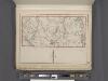
Westchester, Plate No. 27 [Map of Town of York Town] / prepared under the direction of Joseph R. Bien, from general surveys and official records.
From Atlas of Westchester County, New York
Tarrytown
1 : 62500
Tarrytown
1 : 62500
Tarrytown
1 : 62500
Tarrytown
1 : 62500
Tarrytown
1 : 62500
Tarrytown
1 : 62500
Tarrytown
1 : 62500
Tarrytown
1 : 62500
Tarrytown
1 : 62500
![Westchester, Double Page Plate No. 25 [Map of Town of Cortlandt] / prepared under the direction of Joseph R. Bien, from general surveys and official records.](https://images-2.georeferencer.com/images/iiif/891520793015/full/,300/0/native.jpg)

