Maps of Allegheny Plat.

Middle States.
1 : 2800000 Olney, J. (Jesse), 1798-1872
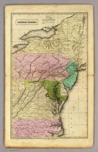
Middle States.
1 : 2800000 Huntington, Hezekiah, 1795-1865
Map of the Middle States.
1 : 3041280 Mitchell, Samuel Augustus
Middle States.
1 : 2900000 Mitchell, Samuel Augustus
Middle States.
1 : 3050000 Smiley, Thomas T.
Middle States.
1 : 3600000 Huntington, Nathaniel G. (Nathaniel Gilbert), 1785-1848
A map of the province of Pensilvania / drawn from the best authorities, by T. Kitchin, gr.
from John H. Levine Collection
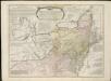
A general map of the middle British colonies, in America, containing Virginia, Maryland, the Delaware counties, Pennsylvania and New Jersey : with the addition of New York, and the greatest part of New England, as also of the bordering parts ...
A general map of the middle British colonies in America, viz. Virginia, Maryland, Delaware, Pensilvania, New-Jersey, New York, Connecticut & Rhode-Island, of Aquanishuonigy the country of the confederate Indians comprehending Aquanishuonigy proper ...

New York, New Jersey, Pennsylvania, and Delaware.
1 : 3652000 Fisher, Richard Swainson
A map of the country between Albemarle Sound and Lake Erie : comprehending the whole of Virginia, Maryland, Delaware and Pennsylvania, with parts of several other of the United States of America / engraved by S. J. Neele, No. 352 Strand, London.
from Notes on the state of Virginia; written in the year 1781, somewhat corrected and enlarged in the winter of 1782, for the use of a foreigner of distinction, in answer to certain queries proposed by him ...
Northern or Middle States.
1 : 3000000 Cornell, S. S. (Sarah S.)
Map of New Jersey and Pennsylvania : exhibiting the post offices, post roads, canals, rail roads, &c. / by David H. Burr (late topographer to the Post Office), geographer to the House of Representatives of the U.S.
from Parts
Middle & Southern States.
Goodrich, S.G.
Map of the interior travels through America, delineating the march of the army

Virginia and Maryland / By H. Moll, geographer.
from Parts
E. United States 7.
1 : 1774080 Letts, Son & Co.
Lord Balitmore's own plan : proposed Maryland/Pennsylvania boundary.
from Maryland
County map of Pennsylvania, New Jersey, Maryland and Delaware ; City of Philadelphia [inset]; City of Baltimore [inset].
from Mitchell's new general atlas, containing maps of the various countries of the world, plans of cities, etc., embraced in fifty-three quarto maps., forming a series of eighty four maps and plans, together with valuable statistical tables.
Pennsylvania.
1 : 2175000 Schonberg & Co.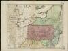
Map of the middle states of America, comprehends New-York, New-Jersey, Pennsylvania, Delaware, and the territory N.W. of Ohio
Russell, John Symonds, Henry Delahoy
Novi Belgii novaeque Angliae nec non partis Virginiae tabula
1 : 2220000 Manhattan (New York, New York) Visscher, Nicolaus a Nicolao Joannis Vißchero
Neu York, Pennsylvanien u. Neu Jersey.
1 : 3400000 Lange, Henry, 1821-1893.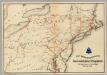
Lines and Metallic Circuit Connections.
1 : 2534400 American Telephone and Telegraph Company
Virginia, Maryland, and Delaware / by H.S. Tanner.
from Charts and maps
Eastern U.S.
1 : 2750000 Cornell, S. S. (Sarah S.)
A correct map of Virginia.
from Carey's general atlas, improved and enlarged : being a collection of maps of the world and quarters, their principal empires, kingdoms, &c.
The State of Virginia from the best authorities, 1796 / B. Tanner sculpt.
from Charts and maps
Map of the state of New York : compiled from the latest authorities.
from Whole