Maps of Allegheny Plat.

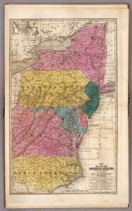
Map of the Middle States.
1 : 3041280 Mitchell, Samuel Augustus
Middle States.
1 : 3050000 Smiley, Thomas T.
Middle States.
1 : 2900000 Mitchell, Samuel Augustus
Middle States.
1 : 2800000 Huntington, Hezekiah, 1795-1865
Middle States.
1 : 2800000 Olney, J. (Jesse), 1798-1872
A map of the country between Albemarle Sound and Lake Erie : comprehending the whole of Virginia, Maryland, Delaware and Pennsylvania, with parts of several other of the United States of America / engraved by S. J. Neele, No. 352 Strand, London.
from Notes on the state of Virginia; written in the year 1781, somewhat corrected and enlarged in the winter of 1782, for the use of a foreigner of distinction, in answer to certain queries proposed by him ...
A map of the province of Pensilvania / drawn from the best authorities, by T. Kitchin, gr.
from John H. Levine Collection
Virginia / S. Lewis, del.
from Virginia
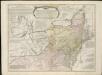
A general map of the middle British colonies, in America, containing Virginia, Maryland, the Delaware counties, Pennsylvania and New Jersey : with the addition of New York, and the greatest part of New England, as also of the bordering parts ...
A general map of the middle British colonies in America, viz. Virginia, Maryland, Delaware, Pensilvania, New-Jersey, New York, Connecticut & Rhode-Island, of Aquanishuonigy the country of the confederate Indians comprehending Aquanishuonigy proper ...

Middle States.
1 : 3600000 Huntington, Nathaniel G. (Nathaniel Gilbert), 1785-1848
Middle States.
1 : 5700000 Grigg, John
New York, New Jersey, Pennsylvania, and Delaware.
1 : 3652000 Fisher, Richard Swainson
Virginia, Maryland, and Delaware / J. Knight sc.
from View of the United States, historical, geographical, and statistical, exhibiting, in a convenient form, the natural and artificial features of the several states, and embracing those leading branches of history and statistics best adapted to develop the present condition of the North American union ... By William Darby.
Map of New Jersey and Pennsylvania : exhibiting the post offices, post roads, canals, rail roads, &c. / by David H. Burr (late topographer to the Post Office), geographer to the House of Representatives of the U.S.
from Parts
Northern or Middle States.
1 : 3000000 Cornell, S. S. (Sarah S.)
Lord Balitmore's own plan : proposed Maryland/Pennsylvania boundary.
from Maryland
Map of the interior travels through America, delineating the march of the army

Virginia and Maryland / By H. Moll, geographer.
from Parts
County map of Pennsylvania, New Jersey, Maryland and Delaware ; City of Philadelphia [inset]; City of Baltimore [inset].
from Mitchell's new general atlas, containing maps of the various countries of the world, plans of cities, etc., embraced in fifty-three quarto maps., forming a series of eighty four maps and plans, together with valuable statistical tables.
A chart of the sea coasts of New-England, New-Jarsey, Virginia, Maryland and Carolina : from C. Cod to C. Hatteras / by John Seller, hydrogr. to the King ; Iames Clerk sculpsit.
from Atlas terrestris, or, A book of mapps of all the empires, monarchies, kingdomes, regions, dominions, principalities, and countreys in the whole world : accomodated with a brief description of the nature and quality of each particular countrey / by Iohn Seller, hydrographer to the Kings most excellent majestie.
Railroad Map Of The Eastern & Middle States.
1 : 380160 Rand McNally and Company
A new map of Virginia from the best authorities / by T. Kitchin, Geogr.
from London magazine, or, Gentleman's monthly intelligencer (1747)
Novi Belgii novaeque Angliae nec non partis Virginiae tabula
1 : 2220000 Manhattan (New York, New York) Visscher, Nicolaus a Nicolao Joannis Vißchero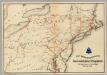
Lines and Metallic Circuit Connections.
1 : 2534400 American Telephone and Telegraph Company
Virginia, Maryland, and Delaware / by H.S. Tanner.
from Charts and maps
A correct map of Virginia.
from Carey's general atlas, improved and enlarged : being a collection of maps of the world and quarters, their principal empires, kingdoms, &c.
Shell Sectional Map No. 3 - Middle Atlantic States.
1 : 1457280 Shell Oil Company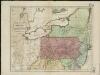
Map of the middle states of America, comprehends New-York, New-Jersey, Pennsylvania, Delaware, and the territory N.W. of Ohio
Russell, John Symonds, Henry Delahoy