Maps of Allegheny Plat.

Middle States.
1 : 3050000 Smiley, Thomas T.
Map of the Middle States.
1 : 3041280 Mitchell, Samuel Augustus
Virginia / S. Lewis, del.
from Virginia
A map of the country between Albemarle Sound and Lake Erie : comprehending the whole of Virginia, Maryland, Delaware and Pennsylvania, with parts of several other of the United States of America / engraved by S. J. Neele, No. 352 Strand, London.
from Notes on the state of Virginia; written in the year 1781, somewhat corrected and enlarged in the winter of 1782, for the use of a foreigner of distinction, in answer to certain queries proposed by him ...
Middle States.
1 : 2800000 Huntington, Hezekiah, 1795-1865
A general map of the middle British colonies, in America, containing Virginia, Maryland, the Delaware counties, Pennsylvania and New Jersey : with the addition of New York, and the greatest part of New England, as also of the bordering parts ...
A general map of the middle British colonies in America, viz. Virginia, Maryland, Delaware, Pensilvania, New-Jersey, New York, Connecticut & Rhode-Island, of Aquanishuonigy the country of the confederate Indians comprehending Aquanishuonigy proper ...

A new map of the most considerable plantations of the English in America / Sutton Nicholls, sculp.
from Parts Sutton Nicholls,
Virginia, Maryland, and Delaware / J. Knight sc.
from View of the United States, historical, geographical, and statistical, exhibiting, in a convenient form, the natural and artificial features of the several states, and embracing those leading branches of history and statistics best adapted to develop the present condition of the North American union ... By William Darby.
New York, New Jersey, Pennsylvania, and Delaware.
1 : 3652000 Fisher, Richard Swainson
Middle States.
1 : 2900000 Mitchell, Samuel Augustus
Middle States.
1 : 5700000 Grigg, John
Map of New Jersey and Pennsylvania : exhibiting the post offices, post roads, canals, rail roads, &c. / by David H. Burr (late topographer to the Post Office), geographer to the House of Representatives of the U.S.
from Parts
Middle States.
1 : 2800000 Olney, J. (Jesse), 1798-1872
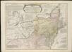
A map of the middle British colonies in North America, first published by Mr. Lewis Evans, of Philadelphia, in 1755; and since corrected and improved, as also extended, with the addition of New England, and bordering parts of Canada ...

A map of the province of Pensilvania / drawn from the best authorities, by T. Kitchin, gr.
from John H. Levine Collection
New York.
from Whole
Virginia and Maryland / By H. Moll, geographer.
from Parts
A GENERAL MAP OF THE MIDDLE BRITISH COLONIES IN AMERICA
1 : 2000000 Delaware Pownall, Thomas
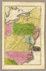
County map of Pennsylvania, New Jersey, Maryland and Delaware ; City of Philadelphia [inset]; City of Baltimore [inset].
from Mitchell's new general atlas, containing maps of the various countries of the world, plans of cities, etc., embraced in fifty-three quarto maps., forming a series of eighty four maps and plans, together with valuable statistical tables.
Bowles's new pocket map of the following independent states of North America: viz. Virginia, Maryland, Delaware, Pensylvania, New Jersey, New York, Connecticut & Rhode Island: comprehending also the habitations & hunting countries of the confederate Indians / by Lewis Evans.
from Charts and maps Lewis Evans,
A General Map of the Middle British Colonies, in America.
1 : 2200000 Robert Sayer and John Bennett (Firm)
Lines and Metallic Circuit Connections.
1 : 2534400 American Telephone and Telegraph Company
A new chart of the coast of North America : from New York to Cape Hatteras, including the bays of Delaware and Chesapeak, with the coasts of New Jersey, Maryland, Virginia and part of the coast of North Carolina / by Captain N. Holland.
from Parts
Novi Belgii Novaeque Angliae nec non partis Virginiae tabula multis in locis emendata
1 : 2000000 a Nicolao Joannis Visschero [S.l.] : [s.n.]
A correct map of Virginia.
from Carey's general atlas, improved and enlarged : being a collection of maps of the world and quarters, their principal empires, kingdoms, &c.
Map no. I : [to accompany A bill in the chancery of New Jersey, at the suit of John, Earl of Stair ... against Benjamin Bond].
from A bill in the chancery of New-Jersey, at the suit of John earl of Stair, and others, proprietors of the eastern-division of New-Jersey; against Benjamin Bond. and some other persons of Elizabeth-Town, distinguished by the name of the Clinker lot right men. With three large maps, done from copper-plates. To which is added; the publications of the Council of proprietors of East New-Jersey, and Mr. Nevill's speeches to the General assembly, concerning the riots committed in New-Jersey, and the pretences of the rioters, and their seducers. These papers will give a better light into the history and constitution of New-Jersey, than any thing hitherto published, the matters whereof have been chiefly collected from records. Published by subscription:
Map of the middle states of North America : shewing the position of the Geneseo country comprehending the counties of Ontario & Steuben as laid off in townships of six miles squar[e] each
1 : 2250000 Maverick, Peter, 1780-1831 Printed by T. & J. Swords, no. 99 Pearl-Street.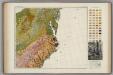
Soil Map of the United States, Section 8. Atlas of American Agriculture.
1 : 2500000 Marbut, Curtis F.