Maps of Piedmont

Virginia / S. Lewis, del.
from Virginia
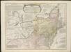
A Map of the British American plantations, extending from Boston in New England to Georgia, including all the back settlements in the respective provinces, as far as the Mississipi
1 : 6350000
A map of the country between Albemarle Sound and Lake Erie : comprehending the whole of Virginia, Maryland, Delaware and Pennsylvania, with parts of several other of the United States of America / engraved by S. J. Neele, No. 352 Strand, London.
from Notes on the state of Virginia; written in the year 1781, somewhat corrected and enlarged in the winter of 1782, for the use of a foreigner of distinction, in answer to certain queries proposed by him ...
130-31. Ohio, Penn., N.Y., Vt., N.H., W.Va., Va., N.C.
1 : 3000000 Touring club italiano
A map of the travels of George Washington
1 : 2500000 Boston (Massachusetts : oblast) National Geographic Society
Cours de l'Ohio, Nlle. Angleterre, Nlle. York, Pensylvanie, Virginie, Caroline.
1 : 2900000 Robert de Vaugondy, Gilles, 1688-1766
A map of those parts of Virginia, North Carolina, South Carolina & Georgia which were the scenes of the most important operations of the southern armies
from Parts
Il Maryland, il Jersey Meridionale, la Delaware e la parte orientale della Virginia, e Carolina Settentrionale.
from Le colonie unite dell' America settentrle : di nuova projezione a s.s.e.e. li Signori Riformatori dello Studio di Padova.
Middle States.
1 : 3050000 Smiley, Thomas T.
Virginia, Maryland, and Delaware / J. Knight sc.
from View of the United States, historical, geographical, and statistical, exhibiting, in a convenient form, the natural and artificial features of the several states, and embracing those leading branches of history and statistics best adapted to develop the present condition of the North American union ... By William Darby.
D'Engelze volkplanting in Virginie / door Iohan Smith bezogt en verder uytgeset = Peuplade des Anglois dans la Virginie / visitée et augmentée par Jean Smith, suivant qu il l'a décrite lui-même dans son voyage ; rectifiée sur de nouvelles observations fa
from Virginia
A new and general map of the middle dominions belonging to the United States of America, viz. Virginia, Maryland, the Delaware-counties, Pennsylvania, New Jersey &c. with the addition of New York & of the greatest part of New England

A General Map of the Middle British Colonies, in America.
1 : 2200000 Robert Sayer and John Bennett (Firm)
A correct map of Virginia.
from Carey's general atlas, improved and enlarged : being a collection of maps of the world and quarters, their principal empires, kingdoms, &c.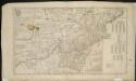
A map of the middle British colonies in North America, first published by Mr. Lewis Evans, of Philadelphia, in 1755; and since corrected and improved, as also extended, with the addition of New England, and bordering parts of Canada ...
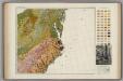
Soil Map of the United States, Section 8. Atlas of American Agriculture.
1 : 2500000 Marbut, Curtis F.
The marches of Lord Cornwallis in the Southern Provinces : now States of North America, comprehending the two Carolinas, with Virginia and Maryland, and the Delaware counties / by William Faden, geographer to the King.
from Charts and maps
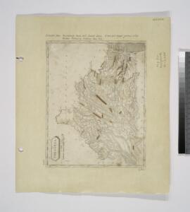
The state of Virginia : from the best authorities / by Samuel Lewis, 1809 ; Smither, sculpt.
from Carey's American atlas.
A GENERAL MAP OF THE MIDDLE BRITISH COLONIES IN AMERICA
1 : 2000000 Delaware Pownall, Thomas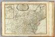
Middle dominions U.S.
1 : 2200000 Robert Laurie & James Whittle
Map of the Middle States.
1 : 3041280 Mitchell, Samuel Augustus
A new chart of the coast of North America : from New York to Cape Hatteras, including the bays of Delaware and Chesapeak, with the coasts of New Jersey, Maryland, Virginia and part of the coast of North Carolina / by Captain N. Holland.
from Parts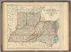
States Of Delaware, Maryland, Virginia (with the District of Columbia) North Carolina, Ohio, Kentucky, Tennessee, And Indiana.
1 : 3453120 Rogers, Henry Darwin
Bowles's new pocket map of the following independent states of North America: viz. Virginia, Maryland, Delaware, Pensylvania, New Jersey, New York, Connecticut & Rhode Island: comprehending also the habitations & hunting countries of the confederate Indians / by Lewis Evans.
from Charts and maps Lewis Evans,
Middle States.
1 : 5700000 Grigg, John
A general map of the middle British colonies, in America, containing Virginia, Maryland, the Delaware counties, Pennsylvania and New Jersey : with the addition of New York, and the greatest part of New England, as also of the bordering parts ...
A general map of the middle British colonies in America, viz. Virginia, Maryland, Delaware, Pensilvania, New-Jersey, New York, Connecticut & Rhode-Island, of Aquanishuonigy the country of the confederate Indians comprehending Aquanishuonigy proper ...

[Map of Virginia, North Carolina, and South Carolina].
from Aussführlich, und umständlicher Bericht von der berühmten Landschafft Carolina : in dem engelländischen America gelegen / an Tag gegeben von Kocherthalern.
151. Centers farm, agricultural products, population, manufactures.
1 : 7000000 Gannett, Henry, 1846-1914; United States. Census Office