Maps of Allegheny Plat.

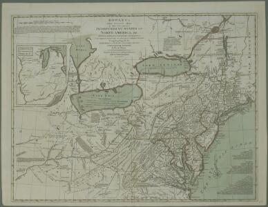
Bowles's new pocket map of the following independent states of North America: viz. Virginia, Maryland, Delaware, Pensylvania, New Jersey, New York, Connecticut & Rhode Island: comprehending also the habitations & hunting countries of the confederate Indians / by Lewis Evans.
from Charts and maps Lewis Evans,
A GENERAL MAP OF THE MIDDLE BRITISH COLONIES IN AMERICA
1 : 2000000 Delaware Pownall, Thomas
Nordoststaaten der Nordamerikanischen Union
1 : 3000000 New York (New York) Mielisch, H. Umbreit, E.
Middle dominions U.S.
1 : 2200000 Robert Laurie & James Whittle
A new and general map of the middle dominions belonging to the United States of America, viz. Virginia, Maryland, the Delaware-counties, Pennsylvania, New Jersey &c. with the addition of New York & of the greatest part of New England

Middle States.
1 : 5700000 Grigg, John
United States ... North Eastern States.
1 : 2851200 Fullarton, A. & Co.
Map New York Central Lines.
1 : 4200000 New York Central Railroad Company
Vereinigte Staaten von Nord-Amerika in 6 blattern, bl. 3
A New Map Of The Seat Of War.
1 : 2534400 Lewis, Samuel
Nördlicher Theil der Vereinigten Staaten
Stieler's Hand-Atlas Stieler, Adolf bei Justus Perthes
A general map of the middle British colonies, in America, containing Virginia, Maryland, the Delaware counties, Pennsylvania and New Jersey : with the addition of New York, and the greatest part of New England, as also of the bordering parts ...
A general map of the middle British colonies in America, viz. Virginia, Maryland, Delaware, Pensilvania, New-Jersey, New York, Connecticut & Rhode-Island, of Aquanishuonigy the country of the confederate Indians comprehending Aquanishuonigy proper ...
Nieuwe en nauwkeurige kaart van een gedeelte van Noord America, behelzende Nieuw England, New York, Pensylvania, New Jersey, Connecticut, Rhode Island, een stuck van Virginia, Kanda en Halifax, ter opheldering der reizen van den Heer P. Kalm
1 : 2000000 C.J. de Huyser direx. P. Mol geletterdt Te Utrecht : by de boekverkopers J. v. Schoonhoven & Comp. en G. v. d. Brink jz.
A Map of the British Empire in America. (Sheet 6).
1 : 2000000 Popple, Henry
A map of the middle British colonies in North America, first published by Mr. Lewis Evans, of Philadelphia, in 1755; and since corrected and improved, as also extended, with the addition of New England, and bordering parts of Canada ...

New York, New Jersey, Pennsylvania, and Delaware.
1 : 3652000 Fisher, Richard Swainson
New York.
from Whole
United States of America, northern part.
1 : 2100000 Pinkerton, John, 1758-1826
A new map of part of the United States of North America, containing those of New York, Vermont, New Hampshire, Massachusets [sic], Connecticut, Rhode Island, Pennsylvania, New Jersey, Delaware, Maryland and Virginia
A Map of the British Empire in America. (Sheet 6).
1 : 2000000 Popple, Henry
Map of New Jersey and Pennsylvania : exhibiting the post offices, post roads, canals, rail roads, &c. / by David H. Burr (late topographer to the Post Office), geographer to the House of Representatives of the U.S.
from Parts
Lehigh Valley line.
1 : 4754200 Lehigh Valley Railroad
Map of the middle states of North America : shewing the position of the Geneseo country comprehending the counties of Ontario & Steuben as laid off in townships of six miles squar[e] each
1 : 2250000 Maverick, Peter, 1780-1831 Printed by T. & J. Swords, no. 99 Pearl-Street.
A General Map of the Middle British Colonies, in America.
1 : 2200000 Robert Sayer and John Bennett (Firm)
United States of America, northern part / drawn under the direction of Mr. Pinkerton by L. Hebert; Neele sculpt. 352 Strand.
from Whole L. Hebert Neele; Mr. Pinkerton,
New York / drawn by S. Lewis ; Tanner, sc.
from Whole
United States.
1 : 3380000 Sharpe, J.
Novi Belgii Novaeque Angliae nec non partis Virginiae tabula multis in locis emendata
1 : 2000000 a Nicolao Joannis Visschero [S.l.] : [s.n.]