Maps of Allegheny Plat.

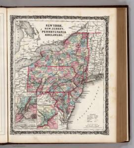
New York, New Jersey, Pennsylvania, and Delaware.
1 : 3652000 Fisher, Richard Swainson
A general map of the middle British colonies, in America, containing Virginia, Maryland, the Delaware counties, Pennsylvania and New Jersey : with the addition of New York, and the greatest part of New England, as also of the bordering parts ...
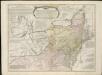
A general map of the middle British colonies in America, viz. Virginia, Maryland, Delaware, Pensilvania, New-Jersey, New York, Connecticut & Rhode-Island, of Aquanishuonigy the country of the confederate Indians comprehending Aquanishuonigy proper ...

Middle States.
1 : 5700000 Grigg, John
A GENERAL MAP OF THE MIDDLE BRITISH COLONIES IN AMERICA
1 : 2000000 Delaware Pownall, Thomas
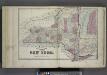
New York.
from Whole
Bowles's new pocket map of the following independent states of North America: viz. Virginia, Maryland, Delaware, Pensylvania, New Jersey, New York, Connecticut & Rhode Island: comprehending also the habitations & hunting countries of the confederate Indians / by Lewis Evans.
from Charts and maps Lewis Evans,
Map of New Jersey and Pennsylvania : exhibiting the post offices, post roads, canals, rail roads, &c. / by David H. Burr (late topographer to the Post Office), geographer to the House of Representatives of the U.S.
from Parts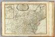
Middle dominions U.S.
1 : 2200000 Robert Laurie & James Whittle
Nördlicher Theil der Vereinigten Staaten
Stieler's Hand-Atlas Stieler, Adolf bei Justus Perthes
Middle States.
1 : 3050000 Smiley, Thomas T.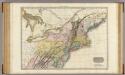
United States of America, northern part.
1 : 2100000 Pinkerton, John, 1758-1826
A map of the province of Pensilvania / drawn from the best authorities, by T. Kitchin, gr.
from John H. Levine Collection
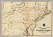
Map of the middle states of North America : shewing the position of the Geneseo country comprehending the counties of Ontario & Steuben as laid off in townships of six miles squar[e] each
1 : 2250000 Maverick, Peter, 1780-1831 Printed by T. & J. Swords, no. 99 Pearl-Street.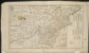
A map of the middle British colonies in North America, first published by Mr. Lewis Evans, of Philadelphia, in 1755; and since corrected and improved, as also extended, with the addition of New England, and bordering parts of Canada ...

Novi Belgii Novaeque Angliae nec non partis Virginiae tabula multis in locis emendata
1 : 2000000 a Nicolao Joannis Visschero [S.l.] : [s.n.]
New York / drawn by S. Lewis ; Tanner, sc.
from Whole
Map of the interior travels through America, delineating the march of the army
Lines and Metallic Circuit Connections.
1 : 2534400 American Telephone and Telegraph Company
United States of America, northern part / drawn under the direction of Mr. Pinkerton by L. Hebert; Neele sculpt. 352 Strand.
from Whole L. Hebert Neele; Mr. Pinkerton,
A General Map of the Middle British Colonies, in America.
1 : 2200000 Robert Sayer and John Bennett (Firm)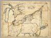
A New Map Of The Seat Of War.
1 : 2534400 Lewis, Samuel
Virginia and Maryland / By H. Moll, geographer.
from Parts
Sheet 2: United States of Nth. America.
1 : 1584000 Tardieu, P.F.
Map of the Middle States.
1 : 3041280 Mitchell, Samuel Augustus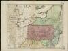
Map of the middle states of America, comprehends New-York, New-Jersey, Pennsylvania, Delaware, and the territory N.W. of Ohio
Russell, John Symonds, Henry Delahoy
County map of Pennsylvania, New Jersey, Maryland and Delaware ; City of Philadelphia [inset]; City of Baltimore [inset].
from Mitchell's new general atlas, containing maps of the various countries of the world, plans of cities, etc., embraced in fifty-three quarto maps., forming a series of eighty four maps and plans, together with valuable statistical tables.
Middle States.
1 : 3600000 Huntington, Nathaniel G. (Nathaniel Gilbert), 1785-1848
Map of the state of New York with part of Upper Canada / engraved & printed by Fenner Sears & Co.
from Whole