Maps of Piedmont

A correct map of Virginia.
from Carey's general atlas, improved and enlarged : being a collection of maps of the world and quarters, their principal empires, kingdoms, &c.
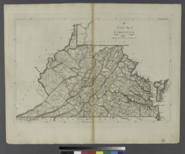
The State of Virginia from the best authorities, 1796 / B. Tanner sculpt.
from Charts and maps
The state of Virginia : from the best authorities / by Samuel Lewis, 1794 ; Smither, sculpt.
from Notes on the State of Virginia. By Thomas Jefferson.
Virginia, Maryland, and Delaware / by H.S. Tanner.
from Charts and maps
Virginia / S. Lewis, del.
from Virginia
A map of the country between Albemarle Sound and Lake Erie : comprehending the whole of Virginia, Maryland, Delaware and Pennsylvania, with parts of several other of the United States of America / engraved by S. J. Neele, No. 352 Strand, London.
from Notes on the state of Virginia; written in the year 1781, somewhat corrected and enlarged in the winter of 1782, for the use of a foreigner of distinction, in answer to certain queries proposed by him ...
Virginia.
from Supplement to the New York observer.
The state of Virginia : from the best authorities / by Samuel Lewis, 1809 ; Smither, sculpt.
from Carey's American atlas.
The tourist's pocket map of the state of Virginia : exhibiting its internal improvements, roads, distances, &c. / by J.H. Young ; engraved by E. Yeager & F. Dankworth.
from Virginia
The marches of Lord Cornwallis in the Southern Provinces : now States of North America, comprehending the two Carolinas, with Virginia and Maryland, and the Delaware counties / by William Faden, geographer to the King.
from Charts and maps
County map of Virginia and West Virginia.
from New general atlas.
Soil Map of the United States, Section 8. Atlas of American Agriculture.
1 : 2500000 Marbut, Curtis F.
Virginia, Maryland, and Delaware / by H.S. Tanner.
from Parts
Il Maryland, il Jersey Meridionale, la Delaware e la parte orientale della Virginia, e Carolina Settentrionale.
from Le colonie unite dell' America settentrle : di nuova projezione a s.s.e.e. li Signori Riformatori dello Studio di Padova.
A new chart of the coast of North America : from New York to Cape Hatteras, including the bays of Delaware and Chesapeak, with the coasts of New Jersey, Maryland, Virginia and part of the coast of North Carolina / by Captain N. Holland.
from Parts
County Map Of Virginia, and North Carolina.
1 : 2800000 Mitchell, Samuel Augustus
Il Maryland, il Jersey Meridionale, la Delaware.
1 : 2100000 Zatta, Antonio
179. Center manufactures, population 1790-1900.
1 : 3900000 Gannett, Henry, 1846-1914
16. Center of population 1790-1900.
1 : 3900000 Gannett, Henry, 1846-1914
Eastern U.S.
1 : 2750000 Cornell, S. S. (Sarah S.)
Map of Virginia and Maryland, constructed from the latest authorities / J.H. Young sc.
from Parts
Virginia, Maryland, and Delaware / J. Knight sc.
from View of the United States, historical, geographical, and statistical, exhibiting, in a convenient form, the natural and artificial features of the several states, and embracing those leading branches of history and statistics best adapted to develop the present condition of the North American union ... By William Darby.
A new map of Virginia from the best authorities / by T. Kitchin, Geogr.
from London magazine, or, Gentleman's monthly intelligencer (1747)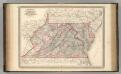
Virginia, Delaware, Maryland, and West Virginia.
1 : 1520000 Johnson, A.J.
Virginia, Delaware, Maryland, and West Virginia.
1 : 1520000 Johnson, A.J.
Middle States.
1 : 3050000 Smiley, Thomas T.
Der Bundesdistrict Columbia, Virginien, Nord-Carolina, Maryland, u. Delaware.
1 : 3400000 Lange, Henry, 1821-1893.
Middle States.
1 : 2900000 Mitchell, Samuel Augustus
Shell Sectional Map No. 3 - Middle Atlantic States.
1 : 1457280 Shell Oil Company