Maps of Piedmont
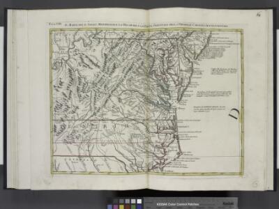
Il Maryland, il Jersey Meridionale, la Delaware e la parte orientale della Virginia, e Carolina Settentrionale.
from Le colonie unite dell' America settentrle : di nuova projezione a s.s.e.e. li Signori Riformatori dello Studio di Padova.
[Map of Virginia, North Carolina, and South Carolina].
from Aussführlich, und umständlicher Bericht von der berühmten Landschafft Carolina : in dem engelländischen America gelegen / an Tag gegeben von Kocherthalern.
Virginia / S. Lewis, del.
from Virginia
A map of those parts of Virginia, North Carolina, South Carolina & Georgia which were the scenes of the most important operations of the southern armies
from Parts
A new chart of the coast of North America : from New York to Cape Hatteras, including the bays of Delaware and Chesapeak, with the coasts of New Jersey, Maryland, Virginia and part of the coast of North Carolina / by Captain N. Holland.
from Parts
The state of Virginia : from the best authorities / by Samuel Lewis, 1809 ; Smither, sculpt.
from Carey's American atlas.
D'Engelze volkplanting in Virginie / door Iohan Smith bezogt en verder uytgeset = Peuplade des Anglois dans la Virginie / visitée et augmentée par Jean Smith, suivant qu il l'a décrite lui-même dans son voyage ; rectifiée sur de nouvelles observations fa
from Virginia
Virginia, Maryland, and Delaware / J. Knight sc.
from View of the United States, historical, geographical, and statistical, exhibiting, in a convenient form, the natural and artificial features of the several states, and embracing those leading branches of history and statistics best adapted to develop the present condition of the North American union ... By William Darby.
Soil Map of the United States, Section 8. Atlas of American Agriculture.
1 : 2500000 Marbut, Curtis F.
A chart of the coast of New York, New Jersey, Pensilvania, Maryland, Virginia, North Carolina, & c.
from Charts and maps

The marches of Lord Cornwallis in the Southern Provinces : now States of North America, comprehending the two Carolinas, with Virginia and Maryland, and the Delaware counties / by William Faden, geographer to the King.
from Charts and maps
A map of the country between Albemarle Sound and Lake Erie : comprehending the whole of Virginia, Maryland, Delaware and Pennsylvania, with parts of several other of the United States of America / engraved by S. J. Neele, No. 352 Strand, London.
from Notes on the state of Virginia; written in the year 1781, somewhat corrected and enlarged in the winter of 1782, for the use of a foreigner of distinction, in answer to certain queries proposed by him ...
A correct map of Virginia.
from Carey's general atlas, improved and enlarged : being a collection of maps of the world and quarters, their principal empires, kingdoms, &c.
States Of Delaware, Maryland, Virginia (with the District of Columbia) North Carolina, Ohio, Kentucky, Tennessee, And Indiana.
1 : 3453120 Rogers, Henry Darwin
Carte des Etats-unis : provinces méridionales.
from Parts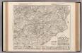
Auto Trail Map. Indiana, Ohio, Virginia, North Carolina, South Carolina, Georgia.
1 : 1893000 Rand McNally and Company
Middle States.
1 : 3050000 Smiley, Thomas T.
The coast of the United States from New York to St. Augustine (4th sheet)
1 : 900000 Blunt, Edmund M. (Edmund March), 1770-1862
Army of the Cumberland.
1 : 7800000 National Tribune Co.
A General Map of the Middle British Colonies, in America.
1 : 2200000 Robert Sayer and John Bennett (Firm)
Shell Sectional Map No. 3 - Middle Atlantic States.
1 : 1457280 Shell Oil Company
County Map Of Virginia, and North Carolina.
1 : 2800000 Mitchell, Samuel Augustus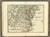
Il Maryland, il Jersey Meridionale, la Delaware.
1 : 2100000 Zatta, Antonio
County map of Virginia and West Virginia.
from New general atlas.
The State of Virginia from the best authorities, 1796 / B. Tanner sculpt.
from Charts and maps
Der Bundesdistrict Columbia, Virginien, Nord-Carolina, Maryland, u. Delaware.
1 : 3400000 Lange, Henry, 1821-1893.
A new map of Virginia from the best authorities / by T. Kitchin, Geogr.
from London magazine, or, Gentleman's monthly intelligencer (1747)
Maryland, Virginia, North Carolina, and South Carolina.
1 : 3651000 Fisher, Richard Swainson