Maps of Virginia

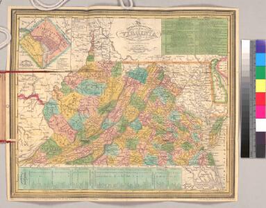
The tourist's pocket map of the state of Virginia : exhibiting its internal improvements, roads, distances, &c. / by J.H. Young ; engraved by E. Yeager & F. Dankworth.
from Virginia
The State of Virginia from the best authorities, 1796 / B. Tanner sculpt.
from Charts and maps
Virginia, Maryland, and Delaware / by H.S. Tanner.
from Charts and maps
A correct map of Virginia.
from Carey's general atlas, improved and enlarged : being a collection of maps of the world and quarters, their principal empires, kingdoms, &c.
Virginia, Maryland, and Delaware / by H.S. Tanner.
from Parts
Virginia.
from Supplement to the New York observer.
The state of Virginia : from the best authorities / by Samuel Lewis, 1794 ; Smither, sculpt.
from Notes on the State of Virginia. By Thomas Jefferson.
A map of the country between Albemarle Sound and Lake Erie : comprehending the whole of Virginia, Maryland, Delaware and Pennsylvania, with parts of several other of the United States of America / engraved by S. J. Neele, No. 352 Strand, London.
from Notes on the state of Virginia; written in the year 1781, somewhat corrected and enlarged in the winter of 1782, for the use of a foreigner of distinction, in answer to certain queries proposed by him ...
Soil Map of the United States, Section 8. Atlas of American Agriculture.
1 : 2500000 Marbut, Curtis F.
County map of Virginia and West Virginia.
from New general atlas.
Eastern U.S.
1 : 2750000 Cornell, S. S. (Sarah S.)
Virginia, Delaware, Maryland, and West Virginia.
1 : 1520000 Johnson, A.J.
Virginia, Delaware, Maryland, and West Virginia.
1 : 1520000 Johnson, A.J.
Map of Virginia and Maryland, constructed from the latest authorities / J.H. Young sc.
from Parts
Virginia, Delaware, Maryland, and West Virginia.
1 : 1487000 Johnson, A.J.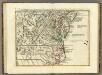
Il Maryland, il Jersey Meridionale, la Delaware.
1 : 2100000 Zatta, Antonio
Virginia.
1 : 4435200 Scott, Joseph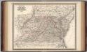
Virginia, Delaware, Maryland, and West Virginia.
1 : 1520000 Johnson, A.J.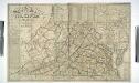
A map of the state of Virginia reduced from the nine sheet map of the state, in conformity to law / by Herman Böye ; engraved by H.S. Tanner and E.B. Dawson.
from Virginia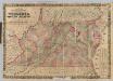
Virginia, Maryland, Delaware.
1 : 760320 Colton, J. H.
Delaware, Maryland, Virginia, West Virginia, District of Columbia
1 : 1280000 Asher & Adams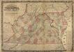
Colton's New Topographical Map of the States of Virginia, Maryland and Delaware
Colton's New Topographical Map of the States of Virginia, Maryland and Delaware, showing also Eastern Tennessee and parts of other adjoining States, all the Fortifications, Military-Stations, Rail-Roads, Common Roads and other internal improvements. Colton’s New Topographical Map of the States of Virginia, Maryland and Delaware, along with parts of Eastern Tennessee and ‘other adjoining states’ was published in 1862 by the New York-based J.H. Colton. The state is divided by county, with a breakdown of area per square mile on the right hand side. Colton was one of the foremost map publishers in American during the 19th century. The majority were coloured to divide the states and individual counties and covered numerous scales, from pocket maps to large atlases. The publishing company also reproduced maps by other publishers. Colton maps are highly valued for their accuracy and detailing and are held by numerous collections across America and the rest of the world. J.H. Colton
Virginia.
1 : 1820000 Colton, G.W.
County Map Of Virginia, and North Carolina.
1 : 2800000 Mitchell, Samuel Augustus
A new map of Virginia from the best authorities / by T. Kitchin, Geogr.
from London magazine, or, Gentleman's monthly intelligencer (1747)
Neueste Karte von Virginia mit seinen Canaelen, Strassen, Eisenbahnen, Entfernungen der Hauptpunkte und Dampfschiff Routen
Grosser Hand-Atlas über alle Theile der Erde in 170 Karten Meyer, J. Verlag des Bibliographischen Instituts
Virginia.
from Charts and maps Published by F. (Fielding) Lucas Jr.: Baltimore,
Virginia.
1 : 1647360 Carey, Mathew
State of Virginia.
1 : 1647360 Carey, Mathew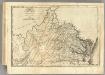
State of Virginia.
1 : 1622000 Lewis, Samuel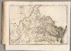
State of Virginia.
1 : 1647360 Carey, Mathew