Maps of Queens County

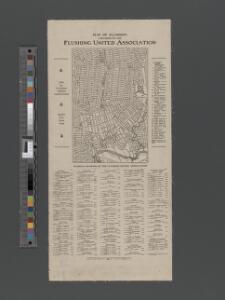
Map of Flushing published by the Flushing United Association. List of references to public buildings.
From Queens
Key Continued
From Atlas 137. Vol. 3, 1902.
Area District Map Section No. 10
from Area district map / City of New York, Board of Estimate and Apportionment.
Queens, Vol. 2, Double Page Plate No. 30; Part of Ward Two Newtown, Trains Meadow, Wood Side and Elmhurst; [Map bounded by Bowery Bay, Flushing Bay, Corona, Junction Ave.; Including Elmhors Ave., Astoria and Flushing Turnpike, Woodside Ave., J
from First and second wards: Long Island City and Newtown.
Key Continued
From Atlas 148, Vol. 10, 1914.
Flushing, College Point, Whitestone, Malba, Beechhurst, Bayside, Queensboro Hill, Willets Point. (cont.)
From District 7
Jackson Heights, North Corona, East Elmhurst. (cont.)
From District 3
Key Continued
From Atlas 141. Vol. 5, 1903.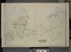
Queens, Vol. 3, Double Page Plate No. 4; Part of ward Three College Point. [Map bounded by 11th Ave., 10th Ave., 7th Ave., 6th Ave., Linden Ave., 5th Ave., Simths Lane, 4th Ave., Lawrence Ave., 3rd Ave., Nostrand Lane, Old Flushing Rd., Whitestone
from Third ward: Flushing.
Height District Map Section No. 10; Height district map / City of New York, Board of Estimate and Apportionment.
from Height district map / City of New York, Board of Estimate and Apportionment. New York (N.Y.). Board of Estimate and Apportionment,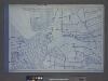
Use District Map Section No. 10; Use district map / City of New York, Board of Estimate and Apportionment.
from Use district map / City of New York, Board of Estimate and Apportionment. New York (N.Y.). Board of Estimate and Apportionment,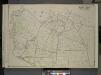
Queens, Vol. 3, Double Page Plate No. 19; Part of ward Three Flushing; [Map bounded by Strongs Causeway Ireland, Mill Road, North Hempstead Turnpike, Crop Road, Union Ave., Hoffman Ave., Boundary Line of Flushing, Jamaica, Head of the Vlei
from Third ward: Flushing.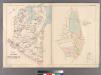
Part of Flushing Village.
from Atlas of Queens Co., Long Island, New York / compiled from official records, private plans & actual surveys by and under the direction of Chester Wolverton.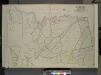
Queens, Vol. 2, Double Page Plate No. 28; Part of Ward Two Newtown, Corona, Hopedale and Richmond Hill; [Map bounded by Flushing Creek, Old Town of Jamaica and Newtown, Boundary Line between Jamaica and Newtown, Dry Harbor Road, Trotting
from First and second wards: Long Island City and Newtown.
Key Continued
From Atlas 148, Vol. 10, 1914.
Kew Gardens Hills, Utopia, Fresh Meadows, Hillcrest, Briarwood, Jamaica Hills. (cont.)
From District 8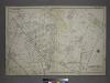
[Plate 18: Bounded by Remsen Street, North Hempstead Plank Road, Corona Avenue, Strongs Causeway, Douglass Street (Queensboro Hills), Ireland Hill Road, North Hempstead Turnpike, Renwick Avenue, Union Avenue, Metropolitan Avenue and Trotting Course.]
from Atlas of the city of New York, borough of Queens, Long Island City, Newtown, Flushing, Jamaica, Far Rockaway, from actual surveys and official plans / by George W. and Walter S. Bromley.
Part of the Borough of Queens, Flushing, Ward 3.
from Atlas of the city of New York, borough of Queens, Long Island City, Newtown, Flushing, Jamaica, Far Rockaway, from actual surveys and official plans / by George W. and Walter S. Bromley.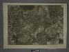
10C - N.Y. City (Aerial Set).
from Sectional aerial maps of the City of New York / [photographed and assembled under the direction of the chief engineer, July 1st, 1924].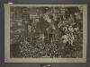
10B - N.Y. City (Aerial Set).
from Sectional aerial maps of the City of New York / [photographed and assembled under the direction of the chief engineer, July 1st, 1924].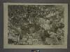
10D - N.Y. City (Aerial Set).
from Sectional aerial maps of the City of New York / [photographed and assembled under the direction of the chief engineer, July 1st, 1924].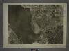
10A - N.Y. City (Aerial Set).
from Sectional aerial maps of the City of New York / [photographed and assembled under the direction of the chief engineer, July 1st, 1924].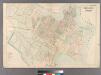
College Point.
from Atlas of Queens Co., Long Island, New York / compiled from official records, private plans & actual surveys by and under the direction of Chester Wolverton.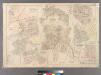
Plate 21: Village of Newtown, Town of Newtown. - Village of Maspeth, Town of Newtown. - Villages if Woodside and Charlotteville, Town of Newtown. - Village of Malvina, Town of Newtown. - Village of Winfield, Town of Newtown. - Village of Laurel Hill, Tow
from Atlas of Queens Co., Long Island, New York / compiled from official records, private plans & actual surveys by and under the direction of Chester Wolverton.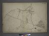
[Plate 17: Bounded by Bowery Bay Road, Shore Road, N. Beach Avenue, Maple Avenue, Old Bowery Road (Flushing Bay), Junction Avenue, Jackson Avenue, Trains Meadow Road and (St. Michaels Cemetery) Astoria and Flushing Turnpike.]
from Atlas of the city of New York, borough of Queens, Long Island City, Newtown, Flushing, Jamaica, Far Rockaway, from actual surveys and official plans / by George W. and Walter S. Bromley.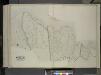
Queens, Vol. 2, Double Page Plate No. 49; Part of Ward Two Newtown; [Map bounded by Flushing Bay, Flushing Creek, Mill Creek, Corona Hempstead Plank Road, Longview St., Fairview St., Home St., Orchard St.; Including Smith St., Plateau St., M
from First and second wards: Long Island City and Newtown.
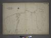
Village of Flushing, an inset map from Topographical Map of the Counties of Kings and Queens.
From Queens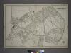
Part of the Borough of Queens, New town, Ward 2.
from Atlas of the city of New York, borough of Queens, Long Island City, Newtown, Flushing, Jamaica, Far Rockaway, from actual surveys and official plans / by George W. and Walter S. Bromley.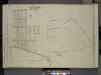
Queens, Vol. 3, Double Page Plate No. 11; Part of Ward Three Flushing. [Map bounded by Bayside Ave., Myrtle Ave., Mitchell Ave., Hildreth Pl., Broadway; Including Murray St., 13th St., 14th St., 15th St., 16th St., 17th St., 18th St., 19th St.,
from Third ward: Flushing.