Maps of Queens County

Flushing, College Point, Whitestone, Malba, Beechhurst, Bayside, Queensboro Hill, Willets Point. (cont.)
From District 7
Key Continued
From Atlas 141. Vol. 5, 1903.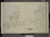
Queens, Vol. 3, Double Page Plate No. 4; Part of ward Three College Point. [Map bounded by 11th Ave., 10th Ave., 7th Ave., 6th Ave., Linden Ave., 5th Ave., Simths Lane, 4th Ave., Lawrence Ave., 3rd Ave., Nostrand Lane, Old Flushing Rd., Whitestone
from Third ward: Flushing.
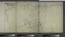
Area District Map Section No. 10
from Area district map / City of New York, Board of Estimate and Apportionment.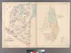
Part of Flushing Village.
from Atlas of Queens Co., Long Island, New York / compiled from official records, private plans & actual surveys by and under the direction of Chester Wolverton.
Height District Map Section No. 10; Height district map / City of New York, Board of Estimate and Apportionment.
from Height district map / City of New York, Board of Estimate and Apportionment. New York (N.Y.). Board of Estimate and Apportionment,
Use District Map Section No. 10; Use district map / City of New York, Board of Estimate and Apportionment.
from Use district map / City of New York, Board of Estimate and Apportionment. New York (N.Y.). Board of Estimate and Apportionment,
Area District Map Section No. 7
from Area district map / City of New York, Board of Estimate and Apportionment.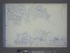
Use District Map Section No. 7; Use district map / City of New York, Board of Estimate and Apportionment.
from Use district map / City of New York, Board of Estimate and Apportionment. New York (N.Y.). Board of Estimate and Apportionment,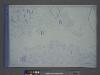
Height District Map Section No. 7; Height district map / City of New York, Board of Estimate and Apportionment.
from Height district map / City of New York, Board of Estimate and Apportionment. New York (N.Y.). Board of Estimate and Apportionment,
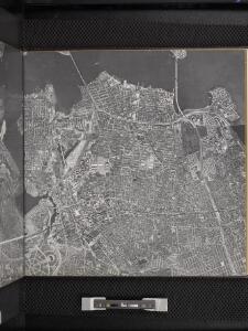
10B - N.Y. City (Aerial Set).
from Sectional aerial maps of the City of New York / [photographed and assembled under the direction of the chief engineer, July 1st, 1924].
10D - N.Y. City (Aerial Set).
from Sectional aerial maps of the City of New York / [photographed and assembled under the direction of the chief engineer, July 1st, 1924].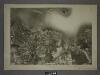
7D - N.Y. City (Aerial Set).
from Sectional aerial maps of the City of New York / [photographed and assembled under the direction of the chief engineer, July 1st, 1924].
Village of Flushing, an inset map from Topographical Map of the Counties of Kings and Queens.
From Queens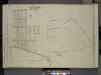
Queens, Vol. 3, Double Page Plate No. 11; Part of Ward Three Flushing. [Map bounded by Bayside Ave., Myrtle Ave., Mitchell Ave., Hildreth Pl., Broadway; Including Murray St., 13th St., 14th St., 15th St., 16th St., 17th St., 18th St., 19th St.,
from Third ward: Flushing.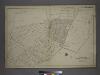
Part of the Borough of Queens, Flushing, Ward 3.
from Atlas of the city of New York, borough of Queens, Long Island City, Newtown, Flushing, Jamaica, Far Rockaway, from actual surveys and official plans / by George W. and Walter S. Bromley.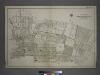
[Plate 21: Bounded by (Mill Creek) Bayside Avenue, Congress Avenue, Myrtle Avenue, Whitestone Avenue, Bayside Avenue, 16th Street, Mitchell Avenue, 19th Street, Broadway, 18th Street, Sanford Avenue, Union Street, Madison Avenue, Main Street, Bradford Av
from Atlas of the city of New York, borough of Queens, Long Island City, Newtown, Flushing, Jamaica, Far Rockaway, from actual surveys and official plans / by George W. and Walter S. Bromley.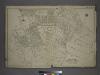
Part of the Borough of Queens, Flushing, Ward 3.
from Atlas of the city of New York, borough of Queens, Long Island City, Newtown, Flushing, Jamaica, Far Rockaway, from actual surveys and official plans / by George W. and Walter S. Bromley.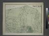
Part of Flushing. Town of Flushing, Queens Co. [Includes Bayside Avenue, Broadway, Sanford Avenue, Queens Avenue, Walnut Avenue, Murray Avenue, Rodman Street, Percy Street, Parsons Avenue and Bowne Avenue.]
from Atlas of Long Island, New York. From recent and actual surveys and records.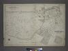
Part of the Borough of Queens, Flushing, Ward 3.
from Atlas of the city of New York, borough of Queens, Long Island City, Newtown, Flushing, Jamaica, Far Rockaway, from actual surveys and official plans / by George W. and Walter S. Bromley.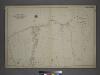
[Plate 26: Willets Point Road (Little Bay), Bell Avenue (Little Neck Bay), Bayside Road and Weststone Road. ]
from Atlas of the city of New York, borough of Queens, Long Island City, Newtown, Flushing, Jamaica, Far Rockaway, from actual surveys and official plans / by George W. and Walter S. Bromley.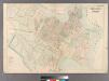
College Point.
from Atlas of Queens Co., Long Island, New York / compiled from official records, private plans & actual surveys by and under the direction of Chester Wolverton.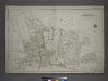
Part of the Borough of Queens, Flushing, Ward 3.
from Atlas of the city of New York, borough of Queens, Long Island City, Newtown, Flushing, Jamaica, Far Rockaway, from actual surveys and official plans / by George W. and Walter S. Bromley.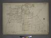
Part of the Borough of Queens, Flushing, Ward 3.
from Atlas of the city of New York, borough of Queens, Long Island City, Newtown, Flushing, Jamaica, Far Rockaway, from actual surveys and official plans / by George W. and Walter S. Bromley.
Index to Streets and House Numbers. Atlas of the city of Brooklyn. [Aberdeen Street - 59th Street.]
from Robinson's atlas of the city of Brooklyn, New York : embracing all territory within its corporate limits; from official records ... / by and under the supervision of E. Robinson and R.H. Pidgeon, civil engineers.
Map of the village of Flushing, Queens County, L.I. : nine miles east of the city of New York / surveyed by order of the trustees, April 1st 1841 Elijah A. Smith, surveyor.
from Queens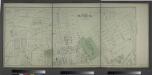
Part of Flushing. Town of Flushing, Queens Co. [Includes Boerum Avenue, Brewster Avenue, Parsons Avenue, Sanford Avenue, Jamaica Avenue, Ireland Avenue, Whittier Avenue, Tennyson Avenue and Longfellow Avenue.]
from Atlas of Long Island, New York. From recent and actual surveys and records.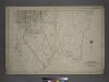
Part of the Borough of Queens, Flushing, Ward 3.
from Atlas of the city of New York, borough of Queens, Long Island City, Newtown, Flushing, Jamaica, Far Rockaway, from actual surveys and official plans / by George W. and Walter S. Bromley.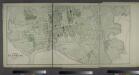
Part of Flushing. Town of Flushing, Queens Co. [Includes Orchard Street, Myrtle Avenue, Bradford Avenue, Prospect Avenue, Sanford Avenue, Maple Avenue, Bank Street, Whitestone Avenue, Farrington Street, Clinton Avenue, Union Avenue, Jamaica Avenue, Lawre
from Atlas of Long Island, New York. From recent and actual surveys and records.