Maps of Queens County

Maps of Queens County

$title$

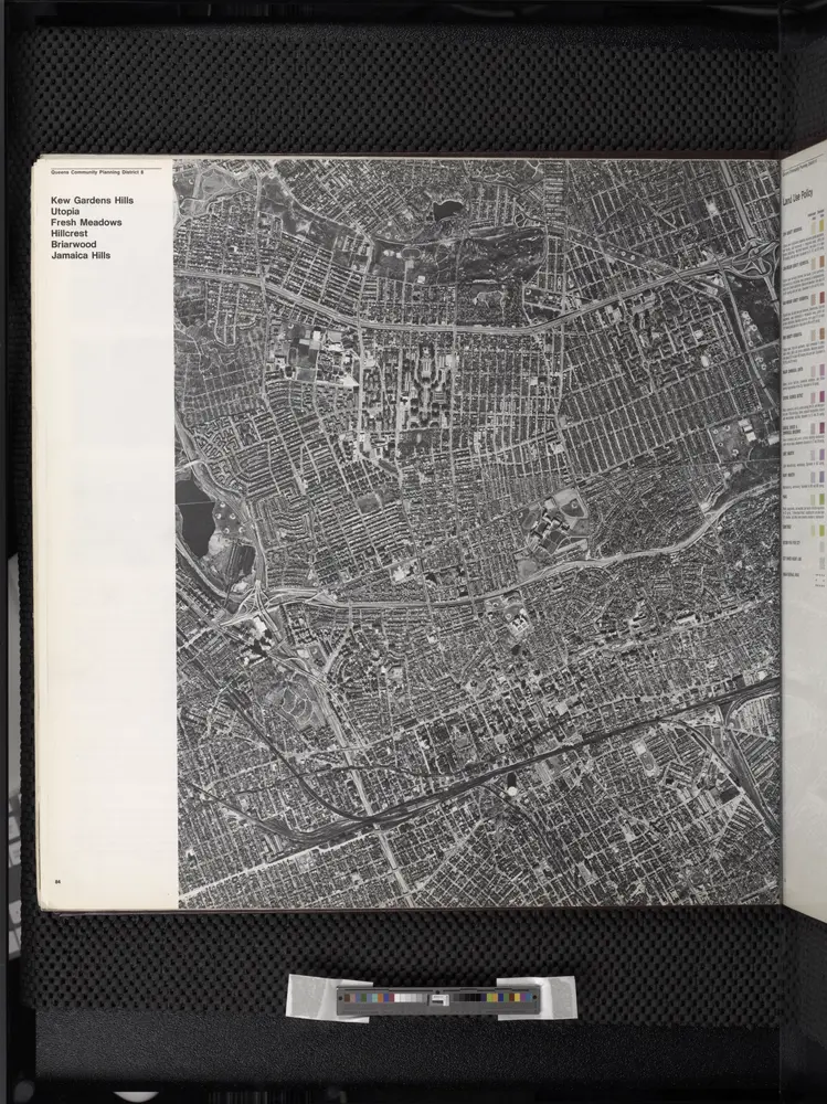
Kew Gardens Hills, Utopia, Fresh Meadows, Hillcrest, Briarwood, Jamaica Hills. (cont.)

From District 8
$title$

Queens, Vol. 3, Double Page Plate No. 19; Part of ward Three Flushing; [Map bounded by Strongs Causeway Ireland, Mill Road, North Hempstead Turnpike, Crop Road, Union Ave., Hoffman Ave., Boundary Line of Flushing, Jamaica, Head of the Vlei

from Third ward: Flushing.
$title$

Key

From Atlas 142a, Vol. 6, 1911.
$title$

Key Continued

From Atlas 148, Vol. 10, 1914.
$title$

[Plate 18: Bounded by Remsen Street, North Hempstead Plank Road, Corona Avenue, Strongs Causeway, Douglass Street (Queensboro Hills), Ireland Hill Road, North Hempstead Turnpike, Renwick Avenue, Union Avenue, Metropolitan Avenue and Trotting Course.]

from Atlas of the city of New York, borough of Queens, Long Island City, Newtown, Flushing, Jamaica, Far Rockaway, from actual surveys and official plans / by George W. and Walter S. Bromley.
$title$

Use District Map Section No. 14; Use district map / City of New York, Board of Estimate and Apportionment.

from Use district map / City of New York, Board of Estimate and Apportionment. New York (N.Y.). Board of Estimate and Apportionment,
$title$

Height District Map Section No. 14; Height district map / City of New York, Board of Estimate and Apportionment.

from Height district map / City of New York, Board of Estimate and Apportionment. New York (N.Y.). Board of Estimate and Apportionment,
$title$

Area District Map Section No. 14; Area district map / City of New York, Board of Estimate and Apportionment.

from Area district map / City of New York, Board of Estimate and Apportionment. New York (N.Y.). Board of Estimate and Apportionment,
$title$

Part of the Borough of Queens, Flushing, Ward 3.

from Atlas of the city of New York, borough of Queens, Long Island City, Newtown, Flushing, Jamaica, Far Rockaway, from actual surveys and official plans / by George W. and Walter S. Bromley.
$title$

14D - N.Y. City (Aerial Set).

from Sectional aerial maps of the City of New York / [photographed and assembled under the direction of the chief engineer, July 1st, 1924].
$title$

14B - N.Y. City (Aerial Set).

from Sectional aerial maps of the City of New York / [photographed and assembled under the direction of the chief engineer, July 1st, 1924].
$title$

10D - N.Y. City (Aerial Set).

from Sectional aerial maps of the City of New York / [photographed and assembled under the direction of the chief engineer, July 1st, 1924].
$title$

Map of the Village of Jamaica, Queens Co., Long Island [plat map].

From Queens
$title$

Part of the Borough of Queens, Jamaica, Ward 4.

from Atlas of the city of New York, borough of Queens, Long Island City, Newtown, Flushing, Jamaica, Far Rockaway, from actual surveys and official plans / by George W. and Walter S. Bromley.
$title$

[Plate 32: Bounded by (Forest Park) Magnolia Avenue, Union Place, Tulip Street, Cleveland Avenue, Washington Avenue, Myrtle Avenue, Division Avenue, ... Maple Grove Cemetery, Newtown Road, Van Wyck Avenue, Atlantic Avenue and Union Place.]

from Atlas of the city of New York, borough of Queens, Long Island City, Newtown, Flushing, Jamaica, Far Rockaway, from actual surveys and official plans / by George W. and Walter S. Bromley.
$title$

Part of the Borough of Queens, Jamaica, Ward 4.

from Atlas of the city of New York, borough of Queens, Long Island City, Newtown, Flushing, Jamaica, Far Rockaway, from actual surveys and official plans / by George W. and Walter S. Bromley.
$title$

Plate 18: [Bounded by Brooklyn Jamaica Plank Road, Van Wyck Avenue, Liberty Avenue and Wyckoff Avenue.]

from Atlas of Queens Co., Long Island, New York / compiled from official records, private plans & actual surveys by and under the direction of Chester Wolverton.
$title$

Part of the Borough of Queens, Flushing, Ward 3.

from Atlas of the city of New York, borough of Queens, Long Island City, Newtown, Flushing, Jamaica, Far Rockaway, from actual surveys and official plans / by George W. and Walter S. Bromley.
$title$

Index to Streets and House Numbers. Atlas of the city of Brooklyn. [Aberdeen Street - 59th Street.]

from Robinson's atlas of the city of Brooklyn, New York : embracing all territory within its corporate limits; from official records ... / by and under the supervision of E. Robinson and R.H. Pidgeon, civil engineers.
$title$

Part of the Borough of Queens, Flushing, Ward 3.

from Atlas of the city of New York, borough of Queens, Long Island City, Newtown, Flushing, Jamaica, Far Rockaway, from actual surveys and official plans / by George W. and Walter S. Bromley.
$title$

Jamaica Village. Queens Co. L.I. [From Highland Avenue to Atlantic Avenue, and from Myrtle Avenue to Franklin Avenue.]

from Atlas of Long Island, New York. From recent and actual surveys and records.
$title$

Queens, V. 1, Double Page Plate No. 5; Part of Jamaica, Ward 4; [Map bounded by Maple Grove Cemetery, Atlantic Ave., Btiggs Ave., Newtown Ward boundary line]

From Fourth and fifth wards: Jamaica and Rockaway.
$title$

Queens, Vol. 1A, Double Page Plate No. 2; Part of Ward 4 Jamaica. [Map bounded by Jamaica Ave., 175th St., 90th Rd., 179th PL., 181st PL.; Including 181st St., 108th Ave., New York Ave.] / by and under the supervision of Hugo Ullitz.

From v. 1A
$title$

Queens, Vol. 3, Double Page Plate No. 6; Part of ward Three Sub Plan; [Map bounded by Flushing Creek; Including Fowler St., Willow St., Lawrence St.]; Part of ward Three Flushing. [Map bounded by Bradford Ave., Sanford Ave., Maple Ave., Prospect

from Third ward: Flushing.
$title$

Queens, Vol. 1, Double Page Plate No. 26; Part of Ward 4; [Map bounded by Woodlawn Ave., Remsen St., New York Ave., Claude PL., Mathias St., James St., Oak St., Platt St.; Including Woodland Ave., Boyland Ave., Evergreen Ave., Fisher Ave.,

from Fourth and fifth wards: Jamaica and Rockaway.
$title$

Queens, Vol. 1, Double Page Plate No. 3; Part of Ward Four, Jamaica; [Map bounded by Atlantic Ave., Napier Ave., Ocean Ave., Hopkinton Ave., Woodhaven Ave., Flushing Ave., Grafton Ave., Hatch Ave., Shattuck Ave., Oakley Ave., Lawn Ave., Union Ave.,

from Fourth and fifth wards: Jamaica and Rockaway.
$title$

Queens, Vol. 1, Double Page Plate No. 8; Part of Ward 4, Jamaica; [Map bounded by Kaplan Ave., Pette Ave., Jeffrey Ave., Hutton Ave., Maple Ave., Haffman Blvd., Sussman Ave., Jefferson Ave., Barrett Ave., Vanderbilt Ave., Keystone Ave., Oak

from Fourth and fifth wards: Jamaica and Rockaway.
$title$

Queens, V. 1, Double Page Plate No. 8; Part of Jamaica, Ward 4; [Map bounded by Verdi Ave., Fulton St., Newtown Rd., Maple Grove Cemetery, boundary line of Flushing (3rd Ward)] / by and under the supervision of Hugo Ullitz.

From v. 1
$title$

Queens, Vol. 1, Double Page Plate No. 11; Sub Plan; Formerly Town of Flushing 3rd Ward; [Map bounded by Grand Ave., Black Stump Road, Charlecote, Croydon Jamaica Estates Road, Edgerton Blvd., Doncaster Blvd., Henley Road, Midland Parkway, Radno

from Fourth and fifth wards: Jamaica and Rockaway.
$title$

Queens, Vol. 1, Double Page Plate No. 6; Part of Ward 4, Jamaica; [Map bounded by Atlantic Ave., Jefferson Ave., Briggs Ave., Johnson Ave., Lefferts Ave., Chichester Ave., Broadway, Belmont Ave., Liberty Ave., Morris Ave., Maure Ave., Frost Ave.

from Fourth and fifth wards: Jamaica and Rockaway.
© MapTiler © OpenStreetMap contributors
How does it work?
These instructions will show you how to find historical maps online.
Getting started
Type the place name in the search box to find the exact location. You can further adjust the search by zooming in and out.
Zoom
Zoom in and out with the buttons or use your mouse or touchpad natively.
Exact Area tool
Click here and draw a rectangle over the map to precisely define the search area.
Set filters
Narrow your search with advanced settings, such as Years (from/to), Fulltext, Publisher, etc.
Results
See the results of your search on the right side. You can scroll down to find more maps of this location.
?

Download OldMapsOnline Mobile