Maps of Queens County
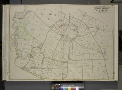
Queens, Vol. 3, Double Page Plate No. 19; Part of ward Three Flushing; [Map bounded by Strongs Causeway Ireland, Mill Road, North Hempstead Turnpike, Crop Road, Union Ave., Hoffman Ave., Boundary Line of Flushing, Jamaica, Head of the Vlei
from Third ward: Flushing.
Kew Gardens Hills, Utopia, Fresh Meadows, Hillcrest, Briarwood, Jamaica Hills. (cont.)
From District 8
Part of the Borough of Queens, Flushing, Ward 3.
from Atlas of the city of New York, borough of Queens, Long Island City, Newtown, Flushing, Jamaica, Far Rockaway, from actual surveys and official plans / by George W. and Walter S. Bromley.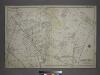
[Plate 18: Bounded by Remsen Street, North Hempstead Plank Road, Corona Avenue, Strongs Causeway, Douglass Street (Queensboro Hills), Ireland Hill Road, North Hempstead Turnpike, Renwick Avenue, Union Avenue, Metropolitan Avenue and Trotting Course.]
from Atlas of the city of New York, borough of Queens, Long Island City, Newtown, Flushing, Jamaica, Far Rockaway, from actual surveys and official plans / by George W. and Walter S. Bromley.
Area District Map Section No. 10
from Area district map / City of New York, Board of Estimate and Apportionment.
10D - N.Y. City (Aerial Set).
from Sectional aerial maps of the City of New York / [photographed and assembled under the direction of the chief engineer, July 1st, 1924].
14B - N.Y. City (Aerial Set).
from Sectional aerial maps of the City of New York / [photographed and assembled under the direction of the chief engineer, July 1st, 1924].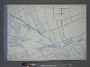
Use District Map Section No. 14; Use district map / City of New York, Board of Estimate and Apportionment.
from Use district map / City of New York, Board of Estimate and Apportionment. New York (N.Y.). Board of Estimate and Apportionment,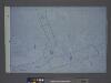
Height District Map Section No. 14; Height district map / City of New York, Board of Estimate and Apportionment.
from Height district map / City of New York, Board of Estimate and Apportionment. New York (N.Y.). Board of Estimate and Apportionment,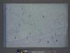
Area District Map Section No. 14; Area district map / City of New York, Board of Estimate and Apportionment.
from Area district map / City of New York, Board of Estimate and Apportionment. New York (N.Y.). Board of Estimate and Apportionment,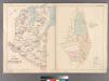
Part of Flushing Village.
from Atlas of Queens Co., Long Island, New York / compiled from official records, private plans & actual surveys by and under the direction of Chester Wolverton.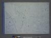
Height District Map Section No. 10; Height district map / City of New York, Board of Estimate and Apportionment.
from Height district map / City of New York, Board of Estimate and Apportionment. New York (N.Y.). Board of Estimate and Apportionment,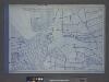
Use District Map Section No. 10; Use district map / City of New York, Board of Estimate and Apportionment.
from Use district map / City of New York, Board of Estimate and Apportionment. New York (N.Y.). Board of Estimate and Apportionment,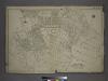
Part of the Borough of Queens, Flushing, Ward 3.
from Atlas of the city of New York, borough of Queens, Long Island City, Newtown, Flushing, Jamaica, Far Rockaway, from actual surveys and official plans / by George W. and Walter S. Bromley.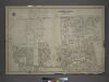
Part of the Borough of Queens, Jamaica, Ward 4.
from Atlas of the city of New York, borough of Queens, Long Island City, Newtown, Flushing, Jamaica, Far Rockaway, from actual surveys and official plans / by George W. and Walter S. Bromley.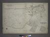
Part of the Borough of Queens, Flushing, Ward 3.
from Atlas of the city of New York, borough of Queens, Long Island City, Newtown, Flushing, Jamaica, Far Rockaway, from actual surveys and official plans / by George W. and Walter S. Bromley.
Index to Streets and House Numbers. Atlas of the city of Brooklyn. [Aberdeen Street - 59th Street.]
from Robinson's atlas of the city of Brooklyn, New York : embracing all territory within its corporate limits; from official records ... / by and under the supervision of E. Robinson and R.H. Pidgeon, civil engineers.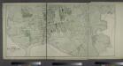
Part of Flushing. Town of Flushing, Queens Co. [Includes Orchard Street, Myrtle Avenue, Bradford Avenue, Prospect Avenue, Sanford Avenue, Maple Avenue, Bank Street, Whitestone Avenue, Farrington Street, Clinton Avenue, Union Avenue, Jamaica Avenue, Lawre
from Atlas of Long Island, New York. From recent and actual surveys and records.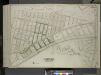
Queens, Vol. 2, Double Page Plate No. 46; Part of Ward Two Newtown; [Map bounded by Meteor St., Livingstone St., Kelvin St., Jewel St., Ibis St., Harvest St., Gown St., Fife St., Euclid St., Dekoven St., Chittenden St., Balfour St., Atom S
from First and second wards: Long Island City and Newtown.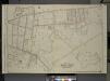
Queens, Vol. 3, Double Page Plate No. 6; Part of ward Three Sub Plan; [Map bounded by Flushing Creek; Including Fowler St., Willow St., Lawrence St.]; Part of ward Three Flushing. [Map bounded by Bradford Ave., Sanford Ave., Maple Ave., Prospect
from Third ward: Flushing.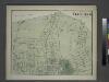
Part of Flushing. Town of Flushing, Queens Co. [Includes Bayside Avenue, Broadway, Sanford Avenue, Queens Avenue, Walnut Avenue, Murray Avenue, Rodman Street, Percy Street, Parsons Avenue and Bowne Avenue.]
from Atlas of Long Island, New York. From recent and actual surveys and records.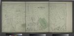
Part of Flushing. Town of Flushing, Queens Co. [Includes Boerum Avenue, Brewster Avenue, Parsons Avenue, Sanford Avenue, Jamaica Avenue, Ireland Avenue, Whittier Avenue, Tennyson Avenue and Longfellow Avenue.]
from Atlas of Long Island, New York. From recent and actual surveys and records.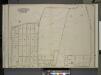
Queens, Vol. 3, Double Page Plate No. 17; Part of ward Three Bayside; [Map bounded by Titus Ave., Rocky Hill Road, Woodhull Ave., Bradford Ave., Torrey Ave., Higgins Ave., Hurd Ave., Jones Ave., Prince Ave., Stratton Ave., Mauriac Ave., Vernon
from Third ward: Flushing.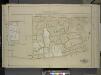
Queens, Vol. 1, Double Page Plate No. 13; Part of Ward 4 Jamaica; (Formerly Town of Flushing 3rd Ward.); [Map bounded by Pueblo Ave., Mc. Laughlin , Flushing Road, Boulevard, Epsom Course, Palermo Ave., Santiago Ave., Cato Ave., Palo Alto
from Fourth and fifth wards: Jamaica and Rockaway.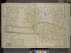
Queens, Vol. 1, Double Page Plate No. 12; Part of Ward 4; Jamaica; [Map bounded by Foothill Ave., Hillside Ave., Columbus Ave., Lincoln Ave., Grant Ave., Max Weber Ave., Cozine Ave., Belleview Ave., Prospect Ave., Park Ave., Colton Ave., Eden
from Fourth and fifth wards: Jamaica and Rockaway.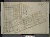
Queens, Vol. 3, Double Page Plate No. 8; Part of Ward Three Flushing. [Map bounded by Madison Ave., Bowne Ave., Parsons Ave., Central Ave., Wilson Ave., Boerum Ave., Sanford Ave., Franklyn Ave., Cypress Ave., Jamaica Ave., Forest Ave., Burling
from Third ward: Flushing.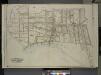
Queens, Vol. 3, Double Page Plate No. 5; Part of ward Three Flushing. [Map bounded by Linden Ave., Bayside Ave., Clinton Ave., Myrtle Ave., Lawrence Ave., Tailor Ave., Congress Ave., Madison Ave., Bradford Ave., Prospect Ave., Jaggar Ave., Jamaica
from Third ward: Flushing.
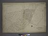
Village of Flushing, an inset map from Topographical Map of the Counties of Kings and Queens.
From Queens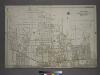
Part of the Borough of Queens, Jamaica, Ward 4.
from Atlas of the city of New York, borough of Queens, Long Island City, Newtown, Flushing, Jamaica, Far Rockaway, from actual surveys and official plans / by George W. and Walter S. Bromley.