Maps of Queens County
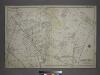
[Plate 18: Bounded by Remsen Street, North Hempstead Plank Road, Corona Avenue, Strongs Causeway, Douglass Street (Queensboro Hills), Ireland Hill Road, North Hempstead Turnpike, Renwick Avenue, Union Avenue, Metropolitan Avenue and Trotting Course.]
from Atlas of the city of New York, borough of Queens, Long Island City, Newtown, Flushing, Jamaica, Far Rockaway, from actual surveys and official plans / by George W. and Walter S. Bromley.
Key Continued
From Atlas 148, Vol. 10, 1914.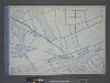
Use District Map Section No. 14; Use district map / City of New York, Board of Estimate and Apportionment.
from Use district map / City of New York, Board of Estimate and Apportionment. New York (N.Y.). Board of Estimate and Apportionment,
Height District Map Section No. 14; Height district map / City of New York, Board of Estimate and Apportionment.
from Height district map / City of New York, Board of Estimate and Apportionment. New York (N.Y.). Board of Estimate and Apportionment,
Area District Map Section No. 14; Area district map / City of New York, Board of Estimate and Apportionment.
from Area district map / City of New York, Board of Estimate and Apportionment. New York (N.Y.). Board of Estimate and Apportionment,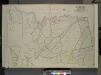
Queens, Vol. 2, Double Page Plate No. 28; Part of Ward Two Newtown, Corona, Hopedale and Richmond Hill; [Map bounded by Flushing Creek, Old Town of Jamaica and Newtown, Boundary Line between Jamaica and Newtown, Dry Harbor Road, Trotting
from First and second wards: Long Island City and Newtown.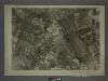
14A - N.Y. City (Aerial Set).
from Sectional aerial maps of the City of New York / [photographed and assembled under the direction of the chief engineer, July 1st, 1924].
Queens V. 3, Plate No. 119 [Map bounded by Hoffman Blvd., Hillside, Simpson St., Barnum Ave.]
From Atlas 137. Vol. 3, 1902.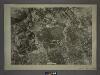
14C - N.Y. City (Aerial Set).
from Sectional aerial maps of the City of New York / [photographed and assembled under the direction of the chief engineer, July 1st, 1924].
Map of the Village of Jamaica, Queens Co., Long Island [plat map].
From Queens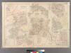
Plate 21: Village of Newtown, Town of Newtown. - Village of Maspeth, Town of Newtown. - Villages if Woodside and Charlotteville, Town of Newtown. - Village of Malvina, Town of Newtown. - Village of Winfield, Town of Newtown. - Village of Laurel Hill, Tow
from Atlas of Queens Co., Long Island, New York / compiled from official records, private plans & actual surveys by and under the direction of Chester Wolverton.
14B - N.Y. City (Aerial Set).
from Sectional aerial maps of the City of New York / [photographed and assembled under the direction of the chief engineer, July 1st, 1924].
Part of the Borough of Queens, Jamaica, Ward 4.
from Atlas of the city of New York, borough of Queens, Long Island City, Newtown, Flushing, Jamaica, Far Rockaway, from actual surveys and official plans / by George W. and Walter S. Bromley.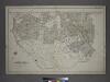
[Plate 14: Bounded by Railroad Avenue, Myrtle Avenue, Corona Avenue, North Hempstead Plank Road, Hoffman Boulevard, Jamaic Avenue and Broadway.]
from Atlas of the city of New York, borough of Queens, Long Island City, Newtown, Flushing, Jamaica, Far Rockaway, from actual surveys and official plans / by George W. and Walter S. Bromley.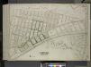
Queens, Vol. 2, Double Page Plate No. 46; Part of Ward Two Newtown; [Map bounded by Meteor St., Livingstone St., Kelvin St., Jewel St., Ibis St., Harvest St., Gown St., Fife St., Euclid St., Dekoven St., Chittenden St., Balfour St., Atom S
from First and second wards: Long Island City and Newtown.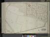
Queens, Vol. 2, Double Page Plate No. 45; Part of Ward Two Newtown; [Map bounded by Burns St., Underwood Road, Ridgeway Road, Upton St., Union Turnpike, Metropolitan Ave. (Williamsburg Turnpike), Trotting Course Lane, White Pot Road]
from First and second wards: Long Island City and Newtown.
10C - N.Y. City (Aerial Set).
from Sectional aerial maps of the City of New York / [photographed and assembled under the direction of the chief engineer, July 1st, 1924].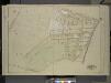
Queens, Vol. 1, Double Page Plate No. 8; Part of Ward 4, Jamaica; [Map bounded by Kaplan Ave., Pette Ave., Jeffrey Ave., Hutton Ave., Maple Ave., Haffman Blvd., Sussman Ave., Jefferson Ave., Barrett Ave., Vanderbilt Ave., Keystone Ave., Oak
from Fourth and fifth wards: Jamaica and Rockaway.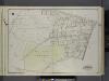
Queens, V. 1, Double Page Plate No. 8; Part of Jamaica, Ward 4; [Map bounded by Verdi Ave., Fulton St., Newtown Rd., Maple Grove Cemetery, boundary line of Flushing (3rd Ward)] / by and under the supervision of Hugo Ullitz.
From v. 1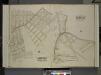
Queens, Vol. 2, Part of Ward Two Corona Park; [Map bounded by Corona Ave., Mill Creek, Walker St., Oxford St., Pine St., Washington Ave.; Including Plateau St., Smith St., Orchard St., Home St., Fairview St., Longview St.]; Part of Ward Two Elm
from First and second wards: Long Island City and Newtown.
Queens, Vol. 2, Double Page Plate No. 48; Part of Ward Two Newtown; [Map bounded by Court St., Marlowe Ave., Romolus St., Otis Ave., Rehan PL.; Including North Hempstead Plank Road, Astoria Road, Hoffman Boulevard, Remsen St. (North Hempst
from First and second wards: Long Island City and Newtown.
Queens, Vol. 1, Double Page Plate No. 9; Sub Plan;[Map bounded by Flushing Ave., Grand Ave., Briarwood Road; Including Alsop St., Lake St., Orchard St., Hutton PL.]; Part of Ward 4, Jamaica; [Map bounded by Terrace Ave., Ocean View Ave., K
from Fourth and fifth wards: Jamaica and Rockaway.
Richmond Hill.
from Atlas of Long Island, New York. From recent and actual surveys and records.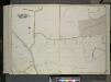
Queens, Vol. 2, Double Page Plate No. 47; Part of Ward Two Newtown; [Map bounded by north Hempstead Plank Road, Livingstone St.; Including Hoffman Boulevard, White Pot Road, Astoria Road]
from First and second wards: Long Island City and Newtown.
Middle Village, Town of Newtown.
from Atlas of Queens Co., Long Island, New York / compiled from official records, private plans & actual surveys by and under the direction of Chester Wolverton.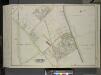
Queens, Vol. 2, Double Page Plate No. 42; Part of Ward Two Newtown; [Map bounded by Trotting Course Lane, Poplar Ave., Hazel Ave., Spruce Ave., Larch Ave.; Including Myrtle Ave., Thompson Ave., Dry Harbar Road, Metropolitan Ave.]
from First and second wards: Long Island City and Newtown.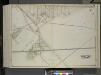
Queens, Vol. 2, Double Page Plate No. 43; Part of Ward Two Newtown; [Map bounded by Metropolitan Ave. (Williams Burg Turnpike), Ward Boundary line between Newtown and Jamaica, Myrtle Ave., Trotting Course Lane, Ocean View Ave.; Including Ma
from First and second wards: Long Island City and Newtown.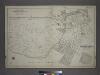
Part of the Borough of Queens, Flushing, Ward 3.
from Atlas of the city of New York, borough of Queens, Long Island City, Newtown, Flushing, Jamaica, Far Rockaway, from actual surveys and official plans / by George W. and Walter S. Bromley.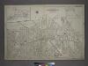
[Plate 32: Bounded by (Forest Park) Magnolia Avenue, Union Place, Tulip Street, Cleveland Avenue, Washington Avenue, Myrtle Avenue, Division Avenue, ... Maple Grove Cemetery, Newtown Road, Van Wyck Avenue, Atlantic Avenue and Union Place.]
from Atlas of the city of New York, borough of Queens, Long Island City, Newtown, Flushing, Jamaica, Far Rockaway, from actual surveys and official plans / by George W. and Walter S. Bromley.
![[Plate 18: Bounded by Remsen Street, North Hempstead Plank Road, Corona Avenue, Strongs Causeway, Douglass Street (Queensboro Hills), Ireland Hill Road, North Hempstead Turnpike, Renwick Avenue, Union Avenue, Metropolitan Avenue and Trotting Course.]](https://images-2.georeferencer.com/images/iiif/793191094550/full/,300/0/native.jpg)

