Maps of University Gardens
Part of the Borough of Queens, Flushing, Ward 3.
from Atlas of the city of New York, borough of Queens, Long Island City, Newtown, Flushing, Jamaica, Far Rockaway, from actual surveys and official plans / by George W. and Walter S. Bromley.
Queens, Vol. 3, Double Page Plate No. 19; Part of ward Three Flushing; [Map bounded by Strongs Causeway Ireland, Mill Road, North Hempstead Turnpike, Crop Road, Union Ave., Hoffman Ave., Boundary Line of Flushing, Jamaica, Head of the Vlei
from Third ward: Flushing.
11C - N.Y. City (Aerial Set).
from Sectional aerial maps of the City of New York / [photographed and assembled under the direction of the chief engineer, July 1st, 1924].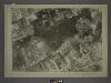
15A - N.Y. City (Aerial Set).
from Sectional aerial maps of the City of New York / [photographed and assembled under the direction of the chief engineer, July 1st, 1924].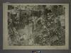
14B - N.Y. City (Aerial Set).
from Sectional aerial maps of the City of New York / [photographed and assembled under the direction of the chief engineer, July 1st, 1924].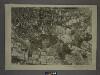
10D - N.Y. City (Aerial Set).
from Sectional aerial maps of the City of New York / [photographed and assembled under the direction of the chief engineer, July 1st, 1924].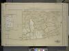
Queens, Vol. 1, Double Page Plate No. 13; Part of Ward 4 Jamaica; (Formerly Town of Flushing 3rd Ward.); [Map bounded by Pueblo Ave., Mc. Laughlin , Flushing Road, Boulevard, Epsom Course, Palermo Ave., Santiago Ave., Cato Ave., Palo Alto
from Fourth and fifth wards: Jamaica and Rockaway.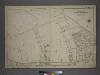
[Plate 38: Bounded by Hillside Avenue, Rocky Hill Road, Hamilton Avenue, Jericho Turnpike, & Hempstead and Jamaica Plank Road.]
from Atlas of the city of New York, borough of Queens, Long Island City, Newtown, Flushing, Jamaica, Far Rockaway, from actual surveys and official plans / by George W. and Walter S. Bromley.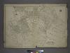
Part of the Borough of Queens, Flushing, Ward 3.
from Atlas of the city of New York, borough of Queens, Long Island City, Newtown, Flushing, Jamaica, Far Rockaway, from actual surveys and official plans / by George W. and Walter S. Bromley.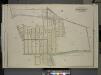
Queens, Vol. 3, Double Page Plate No. 9; Part of Ward Three Flushing. [Map bounded by Sanford Ave., Lucerne PL., Cypress Ave., Queens Ave., Broadway, Franconia Ave., Queens Road, Rocky Hill Road, Cemetery Lane; Including Murray St., Delaware St.,
from Third ward: Flushing.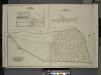
Queens, Vol. 3, Double Page Plate No. 10; Sub Plan Creedmoor. [Map bounded by Pistol Ave., Rang Park Ave., Muskit Ave., Alley Road, Rocky Hill Road, Shaler Ave., Sabre Ave.; Including Power St., Bullet St.]; Sub Plan Creedmoor Lawn. [Map bounded b
from Third ward: Flushing.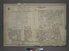
Part of the Borough of Queens, Jamaica, Ward 4.
from Atlas of the city of New York, borough of Queens, Long Island City, Newtown, Flushing, Jamaica, Far Rockaway, from actual surveys and official plans / by George W. and Walter S. Bromley.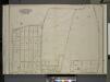
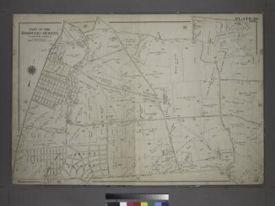
Queens, Vol. 3, Double Page Plate No. 17; Part of ward Three Bayside; [Map bounded by Titus Ave., Rocky Hill Road, Woodhull Ave., Bradford Ave., Torrey Ave., Higgins Ave., Hurd Ave., Jones Ave., Prince Ave., Stratton Ave., Mauriac Ave., Vernon
from Third ward: Flushing.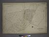
Part of the Borough of Queens, Flushing, Ward 3.
from Atlas of the city of New York, borough of Queens, Long Island City, Newtown, Flushing, Jamaica, Far Rockaway, from actual surveys and official plans / by George W. and Walter S. Bromley.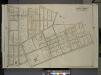
Queens, Vol. 3, Double Page Plate No. 8; Part of Ward Three Flushing. [Map bounded by Madison Ave., Bowne Ave., Parsons Ave., Central Ave., Wilson Ave., Boerum Ave., Sanford Ave., Franklyn Ave., Cypress Ave., Jamaica Ave., Forest Ave., Burling
from Third ward: Flushing.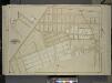
Queens, Vol. 1, Double Page Plate No. 15; Sub Plan; Formerly Town of Flushing 3rd Ward; [Map bounded by Rocky Ave., Lincoln Ave., Hill Road, Old Hillside Ave., Hillside Ave., Inglewood Ave., Chestnut St.]; Part of Ward 4; Jamaica; [Map bounded by
from Fourth and fifth wards: Jamaica and Rockaway.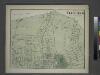
Part of Flushing. Town of Flushing, Queens Co. [Includes Bayside Avenue, Broadway, Sanford Avenue, Queens Avenue, Walnut Avenue, Murray Avenue, Rodman Street, Percy Street, Parsons Avenue and Bowne Avenue.]
from Atlas of Long Island, New York. From recent and actual surveys and records.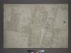
Part of the Borough of Queens, Flushing, Ward 3.
from Atlas of the city of New York, borough of Queens, Long Island City, Newtown, Flushing, Jamaica, Far Rockaway, from actual surveys and official plans / by George W. and Walter S. Bromley.
Index to Streets and House Numbers. Atlas of the city of Brooklyn. [Aberdeen Street - 59th Street.]
from Robinson's atlas of the city of Brooklyn, New York : embracing all territory within its corporate limits; from official records ... / by and under the supervision of E. Robinson and R.H. Pidgeon, civil engineers.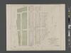
Map of Jamaica Hillcrest, sections C and D, property of the Jamaica Hillcrest Company in the Borough of Queens.
From Queens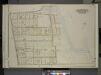
Queens, Vol. 3, Double Page Plate No. 18; Part of ward Three Bayside; [Map bounded by Crocheron Ave., Bayside Boulevard, Bell Ave., Bismarck Ave., Lamartine Ave., Warburton Ave., Ashburton Ave., Montauk Ave., Lawrence Boulevard, Broadway,
from Third ward: Flushing.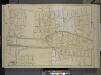
Queens, Vol. 1, Double Page Plate No. 12; Part of Ward 4; Jamaica; [Map bounded by Foothill Ave., Hillside Ave., Columbus Ave., Lincoln Ave., Grant Ave., Max Weber Ave., Cozine Ave., Belleview Ave., Prospect Ave., Park Ave., Colton Ave., Eden
from Fourth and fifth wards: Jamaica and Rockaway.
Kew Gardens Hills, Utopia, Fresh Meadows, Hillcrest, Briarwood, Jamaica Hills. (cont.)
From District 8
Bayside, Auburndale, Oakland Gardens, Little Neck, Douglaston. (cont.)
From District 11
Land use policy (cont.)
From District 11
Map of Flushing published by the Flushing United Association. List of references to public buildings.
From Queens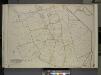
Queens, Vol. 3, Double Page Plate No. 20; Part of ward Three Sub Plan No. 1; [Map bounded by Broadway, Little Neck Road, West end Drive, Lakeville Road]; Part of ward Three Sub Plan No. 2; [Map bounded by Little Neck Bay]; Part of ward Thre
from Third ward: Flushing.
Key
From Atlas 142a, Vol. 6, 1911.
Key Continued
From Atlas 139. Vol. 4, 1901.