Maps of Queens County
Queens, Vol. 3, Double Page Plate No. 18; Part of ward Three Bayside; [Map bounded by Crocheron Ave., Bayside Boulevard, Bell Ave., Bismarck Ave., Lamartine Ave., Warburton Ave., Ashburton Ave., Montauk Ave., Lawrence Boulevard, Broadway,
from Third ward: Flushing.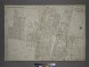
Part of the Borough of Queens, Flushing, Ward 3.
from Atlas of the city of New York, borough of Queens, Long Island City, Newtown, Flushing, Jamaica, Far Rockaway, from actual surveys and official plans / by George W. and Walter S. Bromley.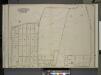
Queens, Vol. 3, Double Page Plate No. 17; Part of ward Three Bayside; [Map bounded by Titus Ave., Rocky Hill Road, Woodhull Ave., Bradford Ave., Torrey Ave., Higgins Ave., Hurd Ave., Jones Ave., Prince Ave., Stratton Ave., Mauriac Ave., Vernon
from Third ward: Flushing.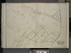
Queens, Vol. 3, Double Page Plate No. 21; Part of ward Three Sub Plan; [Map bounded by Little Neck Bay, Odalls Cove; Including Bay St., Allen St.]; Part of ward Three Douglaston and Little Neck; [Map bounded by Boundary Line of City of New York a
from Third ward: Flushing.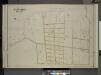
Queens, Vol. 3, Double Page Plate No. 16; Part of ward Three Bayside; [Map bounded by Bell Ave., Little Bayside Road, Shore Ave., Kneeland Ave., Bayside Ave., Bradish Ave., Nicoll Ave., Vista Ave., Cracheron Ave., Waldo Ave., Castor Ave., Fran
from Third ward: Flushing.
11A - N.Y. City (Aerial Set).
from Sectional aerial maps of the City of New York / [photographed and assembled under the direction of the chief engineer, July 1st, 1924].
Height District Map Section No. 11; Height district map / City of New York, Board of Estimate and Apportionment.
from Height district map / City of New York, Board of Estimate and Apportionment. New York (N.Y.). Board of Estimate and Apportionment,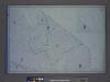
Area District Map Section No. 11; Area district map / City of New York, Board of Estimate and Apportionment.
from Area district map / City of New York, Board of Estimate and Apportionment. New York (N.Y.). Board of Estimate and Apportionment,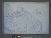
Use District Map Section No. 11; Use district map / City of New York, Board of Estimate and Apportionment.
from Use district map / City of New York, Board of Estimate and Apportionment. New York (N.Y.). Board of Estimate and Apportionment,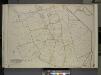
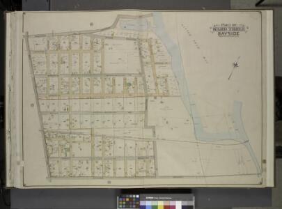
Queens, Vol. 3, Double Page Plate No. 20; Part of ward Three Sub Plan No. 1; [Map bounded by Broadway, Little Neck Road, West end Drive, Lakeville Road]; Part of ward Three Sub Plan No. 2; [Map bounded by Little Neck Bay]; Part of ward Thre
from Third ward: Flushing.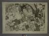
11C - N.Y. City (Aerial Set).
from Sectional aerial maps of the City of New York / [photographed and assembled under the direction of the chief engineer, July 1st, 1924].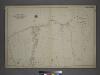
[Plate 26: Willets Point Road (Little Bay), Bell Avenue (Little Neck Bay), Bayside Road and Weststone Road. ]
from Atlas of the city of New York, borough of Queens, Long Island City, Newtown, Flushing, Jamaica, Far Rockaway, from actual surveys and official plans / by George W. and Walter S. Bromley.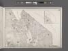
Area District Map Section No. 11
From Area district map
Land use policy (cont.)
From District 11
Bayside, Auburndale, Oakland Gardens, Little Neck, Douglaston. (cont.)
From District 11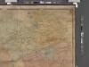
Map of Kings and part of Queens Counties, Long Island, N.Y. / [cartographic material]
From Counties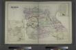
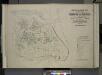
Flushing, Queens Co. L.I. - Douglaston, Town of Flushing, Queens Co. - Hinsdale, Town of Flushing, Kings Co.
from Atlas of Long Island, New York. From recent and actual surveys and records.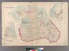
Plate 29: Town of Flushing. - Douglaston. - Bay Side.
from Atlas of Queens Co., Long Island, New York / compiled from official records, private plans & actual surveys by and under the direction of Chester Wolverton.
New handy map of the borough of the Bronx.
From Bronx
Index to the Topographical survey sheets of the borough of the Bronx easterly of the Bronx River.
from Topographical survey and new street system of the borough of the Bronx, easterly of the Bronx River
Map of New-York Bay and Harbor and the environs / founded upon a trigonometrical survey under the direction of F. R. Hassler, superintendent of the Survey of the Coast of the United States ; triangulation by James Ferguson and Edmund Blunt, assistants ;
from New York harbor
Plate 24: Northern part of Town of Yonkers, adjacent to the River.
from Atlas of New York and vicinity : from actual surveys / by and under the direction of F. W. Beers, assisted by A. B. Prindle & others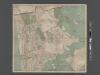
New Map of the Borough of the Bronx, City of New York . . . Circular stickers mark Carnegie Library sites.
From Bronx
New York City, County, and vicinity.
From Manhattan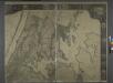
General map of the city of New York, consisting of boroughs of Manhattan, Brooklyn, Bronx, Queens and Richmond : consolidated into one municipality by act of the legislature of the state of New York (Chapter 378 of the laws of 1897) : showing in addition
from Whole
Newtown, Queens Co. L.I.
from Atlas of Long Island, New York. From recent and actual surveys and records.
Hagstrom ́s map of Manhattan and Bronx
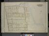
Index map to Vol. 3; Atlas of the Borough of Queens Third Ward city of New York. Published by E. Belcher Hyde; 97 Liberty St., Brooklyn Borough. 1904.
from Third ward: Flushing.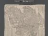
Street Indexed map of the Borough of Queens, also showing the Congressional Districts.
From Queens