Maps of Queens County
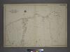
[Plate 26: Willets Point Road (Little Bay), Bell Avenue (Little Neck Bay), Bayside Road and Weststone Road. ]
from Atlas of the city of New York, borough of Queens, Long Island City, Newtown, Flushing, Jamaica, Far Rockaway, from actual surveys and official plans / by George W. and Walter S. Bromley.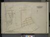
Queens, Vol. 3, Double Page Plate No. 14; Part of ward Three Whitestone; [Map bounded by 14th Ave., Boulevard, 15th Ave., Cryders Lane, Haggertys Lane, 18th Ave., Manhattan Ave., The Vera Terrace, Robinswood Ave., Riverside Ave., 19th Ave., Sh
from Third ward: Flushing.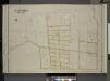
Queens, Vol. 3, Double Page Plate No. 16; Part of ward Three Bayside; [Map bounded by Bell Ave., Little Bayside Road, Shore Ave., Kneeland Ave., Bayside Ave., Bradish Ave., Nicoll Ave., Vista Ave., Cracheron Ave., Waldo Ave., Castor Ave., Fran
from Third ward: Flushing.
Map of Beechhurst (Whitestone Landing)situated in the third ward, Borough of Queens, City of New York.
From Queens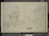
Queens, Vol. 3, Double Page Plate No. 4; Part of ward Three College Point. [Map bounded by 11th Ave., 10th Ave., 7th Ave., 6th Ave., Linden Ave., 5th Ave., Simths Lane, 4th Ave., Lawrence Ave., 3rd Ave., Nostrand Lane, Old Flushing Rd., Whitestone
from Third ward: Flushing.
7D - N.Y. City (Aerial Set).
from Sectional aerial maps of the City of New York / [photographed and assembled under the direction of the chief engineer, July 1st, 1924].
10B - N.Y. City (Aerial Set).
from Sectional aerial maps of the City of New York / [photographed and assembled under the direction of the chief engineer, July 1st, 1924].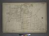
Part of the Borough of Queens, Flushing, Ward 3.
from Atlas of the city of New York, borough of Queens, Long Island City, Newtown, Flushing, Jamaica, Far Rockaway, from actual surveys and official plans / by George W. and Walter S. Bromley.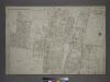
Part of the Borough of Queens, Flushing, Ward 3.
from Atlas of the city of New York, borough of Queens, Long Island City, Newtown, Flushing, Jamaica, Far Rockaway, from actual surveys and official plans / by George W. and Walter S. Bromley.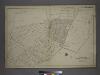
Part of the Borough of Queens, Flushing, Ward 3.
from Atlas of the city of New York, borough of Queens, Long Island City, Newtown, Flushing, Jamaica, Far Rockaway, from actual surveys and official plans / by George W. and Walter S. Bromley.
Part of the Borough of Queens, Flushing, Ward 3.
from Atlas of the city of New York, borough of Queens, Long Island City, Newtown, Flushing, Jamaica, Far Rockaway, from actual surveys and official plans / by George W. and Walter S. Bromley.
Queens, Vol. 3, Double Page Plate No. 11; Part of Ward Three Flushing. [Map bounded by Bayside Ave., Myrtle Ave., Mitchell Ave., Hildreth Pl., Broadway; Including Murray St., 13th St., 14th St., 15th St., 16th St., 17th St., 18th St., 19th St.,
from Third ward: Flushing.
Part of Whitestone Village. Town of Flushing, Queens Co. L.I. [Covers from 3rd Avenue to 17th Avenue, and Boulevard to 17th Street.]
from Atlas of Long Island, New York. From recent and actual surveys and records.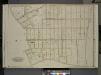
Queens, Vol. 3, Double Page Plate No. 12; Part of Ward Three Whitestone; [Map bounded by 14th Ave., Haggertys Lane, 11th Ave., Clinton Pl., Cryders Lane, 10th Ave., 9th Ave., 8th Ave., 7th Ave., 5th Ave., 4th Ave., Tatham Pl., Private, Howl
from Third ward: Flushing.
Queens, Vol. 3, Double Page Plate No. 15; Part of ward Three Whitestone; [Map bounded by 14th Ave., 11th Ave., Ave. A, Ave. B, Ave. C, Lane, Penn Ave., Willets Point Road, Whitestone Road, Fairview Ave., Plateau Ave., Bay View Ave.; Includ
from Third ward: Flushing.
Map of Flushing published by the Flushing United Association. List of references to public buildings.
From Queens
Flushing
1 : 24000
Flushing
1 : 24000
Flushing
1 : 24000
Flushing
1 : 24000
Flushing
1 : 24000
Flushing
1 : 24000
Flushing
1 : 24000
Flushing
1 : 24000
Flushing
1 : 24000
Key Continued
From Atlas 137. Vol. 3, 1902.
Flushing, College Point, Whitestone, Malba, Beechhurst, Bayside, Queensboro Hill, Willets Point. (cont.)
From District 7
Area District Map Section No. 7
from Area district map / City of New York, Board of Estimate and Apportionment.
Area District Map Section No. 10
from Area district map / City of New York, Board of Estimate and Apportionment.
![[Plate 26: Willets Point Road (Little Bay), Bell Avenue (Little Neck Bay), Bayside Road and Weststone Road. ]](https://images-2.georeferencer.com/images/iiif/207870638583/full/,300/0/native.jpg)

