Maps of Queens County

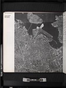
Jackson Heights, North Corona, East Elmhurst. (cont.)
From District 3
Key Continued
From Atlas 148, Vol. 10, 1914.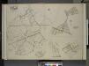
Queens, Vol. 2, Double Page Plate No. 30; Part of Ward Two Newtown, Trains Meadow, Wood Side and Elmhurst; [Map bounded by Bowery Bay, Flushing Bay, Corona, Junction Ave.; Including Elmhors Ave., Astoria and Flushing Turnpike, Woodside Ave., J
from First and second wards: Long Island City and Newtown.
Key
From Atlas 134. Vol. 2, 1915.
Use District Map Section No. 9
from Use district map / City of New York, Board of Estimate and Apportionment.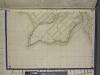
Bronx, Topographical Map Sheet 13; [Map bounded by Cdgewater Road, Halleck St., Coster Ave.; Including Payne St., Barlow St., Falconer St.]
From Topographical map made from surveys by the commissioners of the Department of Public Parks of the City of New York of that part of Westchester County adjacent to the City and County of New York embraced by chapter 534 of laws of 1871 as amended b...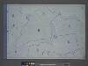
Area District Map Section No. 9; Area district map / City of New York, Board of Estimate and Apportionment.
from Area district map / City of New York, Board of Estimate and Apportionment. New York (N.Y.). Board of Estimate and Apportionment,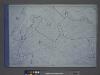
Height District Map Section No. 9; Height district map / City of New York, Board of Estimate and Apportionment.
from Height district map / City of New York, Board of Estimate and Apportionment. New York (N.Y.). Board of Estimate and Apportionment,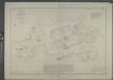
Hell Gate and its approaches / from a trigonometrical survey under the direction of F.R. Hassler and A.D. Bache, superintendents of the Survey of the Coast of the United States.
from New York harbor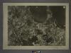
9B - N.Y. City (Aerial Set).
from Sectional aerial maps of the City of New York / [photographed and assembled under the direction of the chief engineer, July 1st, 1924].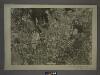
9D - N.Y. City (Aerial Set).
from Sectional aerial maps of the City of New York / [photographed and assembled under the direction of the chief engineer, July 1st, 1924].
6D - N.Y. City (Aerial Set).
from Sectional aerial maps of the City of New York / [photographed and assembled under the direction of the chief engineer, July 1st, 1924].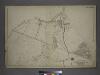
[Plate 17: Bounded by Bowery Bay Road, Shore Road, N. Beach Avenue, Maple Avenue, Old Bowery Road (Flushing Bay), Junction Avenue, Jackson Avenue, Trains Meadow Road and (St. Michaels Cemetery) Astoria and Flushing Turnpike.]
from Atlas of the city of New York, borough of Queens, Long Island City, Newtown, Flushing, Jamaica, Far Rockaway, from actual surveys and official plans / by George W. and Walter S. Bromley.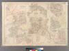
Plate 21: Village of Newtown, Town of Newtown. - Village of Maspeth, Town of Newtown. - Villages if Woodside and Charlotteville, Town of Newtown. - Village of Malvina, Town of Newtown. - Village of Winfield, Town of Newtown. - Village of Laurel Hill, Tow
from Atlas of Queens Co., Long Island, New York / compiled from official records, private plans & actual surveys by and under the direction of Chester Wolverton.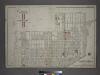
[Plate 5: Bounded by (Con. Ed. Gas Co. of N.Y.)Winthrop Avenue, Blackwell Avenue, Berrian AVenue, Cabinet Street, Riker Avenue, Bowery Bay Road, Flushing Avenue, Woolsey Avenue and (East River) Barclay Street.]
from Atlas of the city of New York, borough of Queens, Long Island City, Newtown, Flushing, Jamaica, Far Rockaway, from actual surveys and official plans / by George W. and Walter S. Bromley.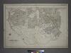
[Plate 14: Bounded by Railroad Avenue, Myrtle Avenue, Corona Avenue, North Hempstead Plank Road, Hoffman Boulevard, Jamaic Avenue and Broadway.]
from Atlas of the city of New York, borough of Queens, Long Island City, Newtown, Flushing, Jamaica, Far Rockaway, from actual surveys and official plans / by George W. and Walter S. Bromley.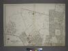
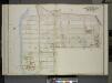
Part of the Borough of Queens, New town, Ward 2.
from Atlas of the city of New York, borough of Queens, Long Island City, Newtown, Flushing, Jamaica, Far Rockaway, from actual surveys and official plans / by George W. and Walter S. Bromley.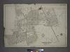
[Plate 13: Bounded by Astoria Road, Middleburg Avenue, Woodside Avenue, Bowery Bay Road, Jamaica Avenue, Grand Gleasonville Avenue, Charlotte Avenue, 10th Street, Jackson Avenue, Trains Meadow Road, Forest Street, Worthington Street, Woodside Avenue, Fis
from Atlas of the city of New York, borough of Queens, Long Island City, Newtown, Flushing, Jamaica, Far Rockaway, from actual surveys and official plans / by George W. and Walter S. Bromley.
Middle Village, Town of Newtown.
from Atlas of Queens Co., Long Island, New York / compiled from official records, private plans & actual surveys by and under the direction of Chester Wolverton.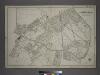
Part of the Borough of Queens, New town, Ward 2.
from Atlas of the city of New York, borough of Queens, Long Island City, Newtown, Flushing, Jamaica, Far Rockaway, from actual surveys and official plans / by George W. and Walter S. Bromley.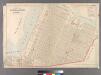
Part of Long Island City, Ward No. 5 (Steinway)
from Atlas of Queens Co., Long Island, New York / compiled from official records, private plans & actual surveys by and under the direction of Chester Wolverton.
Queens, Vol. 2, Double Page Plate No. 11; Part of Long Island City Ward One (Part of Old Ward 5); [Map bounded by East River, Berrians Island, Berrians Creek, Proposed Canal, Rapelje Ave., Debevoise Ave., Lawrence St., chauncey St., Goodric
from First and second wards: Long Island City and Newtown.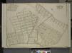
Queens, Vol. 2, Double Page Plate No. 15; Part of Ward Two Elmhurst; [Map bounded by Division St., Junction Ave., Newtown Road, Court St., Broadway, Astoria and Flushing Turnpike, Orchard Ave.; Including 12th St., 11th St., 10Th St., 9th St., 8
from First and second wards: Long Island City and Newtown.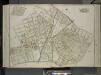
Queens, Vol. 2, Double Page Plate No. 25; Sub Plan; [Map bounded by Junction Ave., Canton St., Division St.; Including Forest St., Warren St.]; Part of Ward Two Elmhurst; [Map bounded by Roosevelt Ave., Division St., Junction Ave., Newtown Road; I
from First and second wards: Long Island City and Newtown.
Queens, vol. 2, Double Page Plate No. 12; Part of Long Island City Ward One (Part of Old Ward 5); [Map bounded by Cabinet St., Riker Ave., Bowery Bay Road, Flushing Ave., Potter Ave., Albert St.; Including Winthrop Ave., Proposed Canal, Back
from First and second wards: Long Island City and Newtown.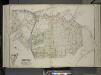
Queens, Vol. 2, Double Page Plate No. 26; Part of Ward two Nassau Heights and Newtown Heights; [Map bounded by Broadway, Court St., Horse Brook Road, Hoffman Boulevard, Trotting Course Lane, Dry Harbor, Hnson Ave., Bowne St., Corinth PL.;
from First and second wards: Long Island City and Newtown.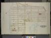
Queens, Vol. 2, Double Page Plate No. 11; Part of Long Island City Ward One (Part of Old Ward Five); [Map bounded by Old Bowery Bay Road, Flushing Ave., Potter Ave., Albert St., Winthrop Ave., Rapelje St.; Including Proposed Canal, Berrians
from First and second wards: Long Island City and Newtown.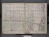
Queens, V. 2, Double Page Plate No. 10; Part of Long Island City, Ward 1; [Map bounded by Winthrop Ave., 11th Ave., Woolsey Ave., East River] / by and under the supervision of Hugo Ullitz.
From v. 2
Queens, Vol. 2, Double Page Plate No. 10; Part of Long Island City ward One (Part of Old Ward Five); [Map bounded by Winthrop Ave., Albert St., Flushing Ave.; Including Woolsey Ave., Boulevard]
from First and second wards: Long Island City and Newtown.