Maps of Queens County
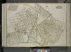
Queens, Vol. 2, Double Page Plate No. 25; Sub Plan; [Map bounded by Junction Ave., Canton St., Division St.; Including Forest St., Warren St.]; Part of Ward Two Elmhurst; [Map bounded by Roosevelt Ave., Division St., Junction Ave., Newtown Road; I
from First and second wards: Long Island City and Newtown.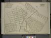
Queens, Vol. 2, Double Page Plate No. 15; Part of Ward Two Elmhurst; [Map bounded by Division St., Junction Ave., Newtown Road, Court St., Broadway, Astoria and Flushing Turnpike, Orchard Ave.; Including 12th St., 11th St., 10Th St., 9th St., 8
from First and second wards: Long Island City and Newtown.
Newtown, Tn. of Newtown, Queens Co.
from Atlas of Long Island, New York. From recent and actual surveys and records.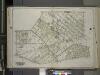
Queens, Vol. 2A, Double Page Plate No. 12; Part of Ward Two Newtown. [Map bounded by Roosevelt Ave., Vandine St., Card PL., Hanover Ave., Maurice Ave.; Including Queens Blvd., 19th St., Woodside Ave., Baxter Ave.] / by and under the supervision of Hug...
From v. 2A
Queens V. 10, Plate No. 72 [Map bounded by Chicago St., Lewis Ave., Queens Blvd., Broadway, Horton]
From Atlas 148, Vol. 10, 1914.
Queens V. 10, Plate No. 73 [Map bounded by Hanover Ave., Maurice Ave., Chicago St., Corona Ave.]
From Atlas 148, Vol. 10, 1914.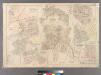
Plate 21: Village of Newtown, Town of Newtown. - Village of Maspeth, Town of Newtown. - Villages if Woodside and Charlotteville, Town of Newtown. - Village of Malvina, Town of Newtown. - Village of Winfield, Town of Newtown. - Village of Laurel Hill, Tow
from Atlas of Queens Co., Long Island, New York / compiled from official records, private plans & actual surveys by and under the direction of Chester Wolverton.
9D - N.Y. City (Aerial Set).
from Sectional aerial maps of the City of New York / [photographed and assembled under the direction of the chief engineer, July 1st, 1924].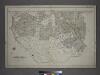
[Plate 14: Bounded by Railroad Avenue, Myrtle Avenue, Corona Avenue, North Hempstead Plank Road, Hoffman Boulevard, Jamaic Avenue and Broadway.]
from Atlas of the city of New York, borough of Queens, Long Island City, Newtown, Flushing, Jamaica, Far Rockaway, from actual surveys and official plans / by George W. and Walter S. Bromley.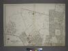
Part of the Borough of Queens, New town, Ward 2.
from Atlas of the city of New York, borough of Queens, Long Island City, Newtown, Flushing, Jamaica, Far Rockaway, from actual surveys and official plans / by George W. and Walter S. Bromley.
Middle Village, Town of Newtown.
from Atlas of Queens Co., Long Island, New York / compiled from official records, private plans & actual surveys by and under the direction of Chester Wolverton.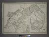
Part of the Borough of Queens, New town, Ward 2.
from Atlas of the city of New York, borough of Queens, Long Island City, Newtown, Flushing, Jamaica, Far Rockaway, from actual surveys and official plans / by George W. and Walter S. Bromley.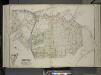
Queens, Vol. 2, Double Page Plate No. 26; Part of Ward two Nassau Heights and Newtown Heights; [Map bounded by Broadway, Court St., Horse Brook Road, Hoffman Boulevard, Trotting Course Lane, Dry Harbor, Hnson Ave., Bowne St., Corinth PL.;
from First and second wards: Long Island City and Newtown.
West Flushing. Tn. of Newtown, Queens Co.
from Atlas of Long Island, New York. From recent and actual surveys and records.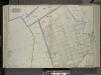
Queens, Vol. 2, Double Page Plate No. 21; Sub Plan No. 1; [Map bounded by Flushing and Newtown Road; Including Junction Ave.]; Part of Ward Two Newtown; [Old Bowery Road, Old Junction Ave., Flushing and Newtown Road, 12th St., Whitney Ave., 11th
from First and second wards: Long Island City and Newtown.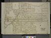
Queens, Vol. 2, Double Page Plate No. 17; Part of Ward Two Corona; [Map bounded by Flushing Plank Road, Meadow St., Apple St., Grand Ave., Lake St., Part St., Main St., Locust St., Rail Road Ave., Summit Ave., Myrtle Ave.; Including Platea
from First and second wards: Long Island City and Newtown.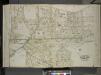
Queens, Vol. 2, Double Page Plate No. 23; Part of Ward Two Corona; [Map bounded by Flushing Plank Road, Peartree Summit Ave., Meadow St., Apple St., Grand Ave. (Roosevelt St.), Lake St., Park St., Rail Road Ave., Willow St., New Ave., Oak St.
from First and second wards: Long Island City and Newtown.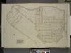
Queens, Vol. 2, Double Page Plate No. 19; Part of Ward Two Nassau Heights and Newtown Heights; [Map bounded by Grand St., Jamaica Ave., Trotting Course Lane; Including Wooley Ave., Johnson Ave., Maiden Lane]
from First and second wards: Long Island City and Newtown.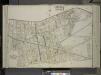
Queens, Vol. 2, Double Page Plate No. 16; Part of Ward two Winfield; [Map bounded by Woodside Ave., Broadway, Shell Road (Newtown and Bushwick Turnpike), Thomson Ave., Maurice Ave., Manilla St.; Including Calamus Road, William St., Clinton
from First and second wards: Long Island City and Newtown.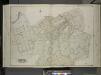
Queens, Vol. 2, Double Page Plate No. 24; Part of Ward Two Corona Park; [Map bounded by Grand Ave., Pine St., Rapelye Ave., Washington Ave., Moore St., Central Ave., Corona Ave., Plateau St., Smith St., Orchard St., Home St., Fairview St.
from First and second wards: Long Island City and Newtown.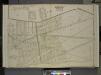
Queens, Vol. 2, Double Page Plate No. 14; Part of Ward Two Winfield; [Map bounded by Worthington St., 1st St., Grove St., Woodside Ave., Broadway, Shell Road (Newtown and Bushwick Turn Pike), Thomson Ave.; Including Maurice Ave., Manilla St.
from First and second wards: Long Island City and Newtown.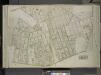
Queens, Vol. 2, Double Page Plate No. 17; Part of Ward Two Elmhurst; [Map bounded by Jackson Ave., 12th St., 13th St., 14th St., 15th St., 16th St., 17th St., 18th St., 19th St., 20th St., 21st St., 22nd Sr., 23rd St., 24th St., 25th St., 26th
from First and second wards: Long Island City and Newtown.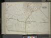
Queens, Vol. 2, Double Page Plate No. 48; Part of Ward Two Newtown; [Map bounded by Court St., Marlowe Ave., Romolus St., Otis Ave., Rehan PL.; Including North Hempstead Plank Road, Astoria Road, Hoffman Boulevard, Remsen St. (North Hempst
from First and second wards: Long Island City and Newtown.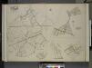
Queens, Vol. 2, Double Page Plate No. 30; Part of Ward Two Newtown, Trains Meadow, Wood Side and Elmhurst; [Map bounded by Bowery Bay, Flushing Bay, Corona, Junction Ave.; Including Elmhors Ave., Astoria and Flushing Turnpike, Woodside Ave., J
from First and second wards: Long Island City and Newtown.
Use District Map Section No. 9
from Use district map / City of New York, Board of Estimate and Apportionment.
Key Continued
From Atlas 148, Vol. 10, 1914.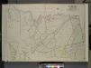
Queens, Vol. 2, Double Page Plate No. 28; Part of Ward Two Newtown, Corona, Hopedale and Richmond Hill; [Map bounded by Flushing Creek, Old Town of Jamaica and Newtown, Boundary Line between Jamaica and Newtown, Dry Harbor Road, Trotting
from First and second wards: Long Island City and Newtown.
Key Continued
From Atlas 148, Vol. 10, 1914.
Jackson Heights, North Corona, East Elmhurst. (cont.)
From District 3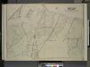
![Queens, Vol. 2, Double Page Plate No. 25; Sub Plan; [Map bounded by Junction Ave., Canton St., Division St.; Including Forest St., Warren St.]; Part of Ward Two Elmhurst; [Map bounded by Roosevelt Ave., Division St., Junction Ave., Newtown Road; I](https://images-2.georeferencer.com/images/iiif/726625070585/full/,300/0/native.jpg)

