Maps of Queens County
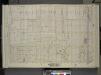
Queens, Vol. 2, Double Page Plate No. 10; Part of Long Island City ward One (Part of Old Ward Five); [Map bounded by Winthrop Ave., Albert St., Flushing Ave.; Including Woolsey Ave., Boulevard]
from First and second wards: Long Island City and Newtown.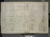
Queens, Vol. 2, Double Page No. 10; Part of Long Island City Ward One (Part of Old Ward 5); [Map bounded by Boulevard, Winthrop Ave., Wolcott Ave., Ditmars Ave., Potter Ave., Woolsey Ave., Flushing Ave., Nassau Ave., Frankfort Ave., Steinw
from Long Island City.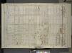
Queens, Vol. 2, Double Page Plate No. 10; Part of Long Island City Ward One (Part of Old Ward 5); [Map bounded by Winthrop Ave., Albert St., Flushing Ave.; Including Woolsey Ave., Boulevard]
from First and second wards: Long Island City and Newtown.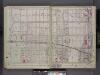
Queens, V. 2, Double Page Plate No. 10; Part of Long Island City, Ward 1; [Map bounded by Winthrop Ave., 11th Ave., Woolsey Ave., East River] / by and under the supervision of Hugo Ullitz.
From v. 2
Queens V. 2, Plate No. 57 [Map bounded by Goodrich, Woolsey Ave., Van Alst Ave., Potter Ave.]
From Atlas 134. Vol. 2, 1915.
Queens V. 2, Plate No. 61 [Map bounded by 4th Ave., Ditmars Ave., Goodrich, Wolcott Ave.]
From Atlas 134. Vol. 2, 1915.
Queens V. 2, Plate No. 55 [Map bounded by Goodrich, Ditmars Ave., Van Alst Ave., Wolcott Ave.]
From Atlas 134. Vol. 2, 1915.
Queens V. 2, Plate No. 60 [Map bounded by 4th Ave., Wolcott Ave., Goodrich, Winthrop Ave.]
From Atlas 134. Vol. 2, 1915.
Queens V. 2, Plate No. 68 [Map bounded by Steinway, Potter Ave., 4th Ave., Ditmars Ave.]
From Atlas 134. Vol. 2, 1915.
Queens V. 2, Plate No. 56 [Map bounded by Goodrich, Potter Ave., Van Alst Ave., Ditmars Ave.]
From Atlas 134. Vol. 2, 1915.
Queens V. 2, Plate No. 74 [Map bounded by 16th Ave., Potter Ave., Steinway Ave., Ditmars Ave.]
From Atlas 134. Vol. 2, 1915.
Queens V. 2, Plate No. 67 [Map bounded by Steinway Ave., Ditmars Ave., 4th Ave., Wolcott Ave.]
From Atlas 134. Vol. 2, 1915.
Queens V. 2, Plate No. 63 [Map bounded by 4th Ave., Woolsey Ave., Goodrich, Potter Ave.]
From Atlas 134. Vol. 2, 1915.
Queens V. 2, Plate No. 48 [Map bounded by Van Alst Ave., Wolcott Ave., East River, Winthrop Ave.]
From Atlas 134. Vol. 2, 1915.
Queens V. 2, Plate No. 69 [Map bounded by Steinway Ave., Woolsey Ave., 4th Ave., Potter Ave.]
From Atlas 134. Vol. 2, 1915.
Queens V. 2, Plate No. 54 [Map bounded by Goodrich, Wolcott Ave., Van Alst Ave., Winthrop Ave.]
From Atlas 134. Vol. 2, 1915.
Queens V. 2, Plate No. 65 [Map bounded by Steinway Ave., Winthrop Ave., 4th Ave., Riker Ave.]
From Atlas 134. Vol. 2, 1915.
Queens V. 2, Plate No. 73 [Map bounded by 16th Ave., Ditmars Ave., Steinway Ave., Wolcott Ave.]
From Atlas 134. Vol. 2, 1915.
Queens V. 2, Plate No. 49 [Map bounded by Van Alst Ave., Ditmars Ave., Boulevard, Wolcott Ave.]
From Atlas 134. Vol. 2, 1915.
Queens V. 2, Plate No. 62 [Map bounded by 4th Ave., Potter Ave., Goodrich, Ditmars Ave.]
From Atlas 134. Vol. 2, 1915.
Queens V. 2, Plate No. 75 [Map bounded by 16th Ave., Flushing Ave., Steinway Ave., Potter Ave.]
From Atlas 134. Vol. 2, 1915.
Queens V. 2, Plate No. 70 [Map bounded by 9th Ave., Flushing Ave., 2nd Ave., Woolsey Ave.]
From Atlas 134. Vol. 2, 1915.
Queens V. 2, Plate No. 66 [Map bounded by Steinway Ave., Wolcott Ave., 4th Ave., Winthrop Ave.]
From Atlas 134. Vol. 2, 1915.
Queens V. 2, Plate No. 53 [Map bounded by Astoria Light, Heat & Power Co. Gas Plant]
From Atlas 134. Vol. 2, 1915.
Queens V. 2, Plate No. 16 [Map bounded by Flushing Ave., Carver, Grand Ave., Crescent]
From Atlas 134. Vol. 2, 1915.
Queens V. 2, Plate No. 50 [Map bounded by Van Alst Ave., Potter Ave., Boulevard, Ditmars Ave.]
From Atlas 134. Vol. 2, 1915.
Queens V. 2, Plate No. 80 [Map bounded by 19th Ave., Potter Ave., 16th Ave., Ditmars Ave.]
From Atlas 134. Vol. 2, 1915.
Queens V. 2, Plate No. 52 [Map bounded by Woolsey Ave., Barclay, Hoyt Ave., Boulevard]
From Atlas 134. Vol. 2, 1915.
Queens V. 2, Plate No. 36 [Map bounded by 2nd Ave., Flushing Ave., Crescent, Hoyt Ave.]
From Atlas 134. Vol. 2, 1915.
![Queens, Vol. 2, Double Page Plate No. 10; Part of Long Island City ward One (Part of Old Ward Five); [Map bounded by Winthrop Ave., Albert St., Flushing Ave.; Including Woolsey Ave., Boulevard]](https://images-2.georeferencer.com/images/iiif/207377931723/full/,300/0/native.jpg)

