Maps of Belgium

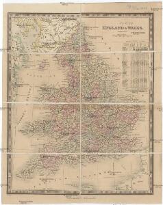
England & Wales
Anglie Wyld, James Kitchin, Thomas James Wyld
Carte de l'Angleterre avec les divisions Saxonnes
Anglie Raffelsperger, Franz Kitchin, Thomas
Magnae Britanniae pars meridionalis, in qua regnum Angliae tam in septem antiqua Anglo-saxonum regna quam in omnes hodiernas regiones accurate divisum hic ostenditur
Anglie Homann, Johann Baptist Visscher, Nicolaes Jansz. Ioh. Bapt. Homan[n
Britanniae sive Angliae regnum
Anglie Seutter, Matthäus Vilém Oranžský sumtibus Matthaei Seutteri
Niederlande, Belgien.
1 : 800000 Kiepert, Heinrich, 1818-1899
Holland and Belgium.
1 : 1300000 Colton, G.W.
Carte du Royaume des Pays-Bas.
1 : 1360000 Vivien de St Martin, L.
Pays-Bas.
1 : 1000000 Brue, Adrien Hubert, 1786-1832
Nova et accurata descriptio XVII provinciarvm Germaniae inferiroris nec non teritorii embdensis
1 : 902400 Nizozemsko Galle, Johannes apud Ioannem Galleum
The Kingdom of the Netherlands
1 : 1495000 Belgie Walker, C. Baldwin & Gradock

Nieuwe kaart van het Koningrijk der Nederlanden en het Groot-Hertogdom Luxemburg : met aanwijzing der nieuwe postwegen = Nouvelle carte du Royaume des Pays-Bas et du Grand-Duché de Luxembourg : avec les routes de poste / dressé et gravé par C. van Baarsel et Fils
1 : 580000 Baarsel, C. van La Haye : F.J. Weygand
Regni di Olanda e del Belgio, e Gran Ducato di Luembourg.
1 : 1010000 Marzolla, Benedetto
Holland and Belgium.
1 : 1290000 Colton, G.W.
[Historisch-geographischer Atlas zu den allgemeinen Geschichtswerken von C. v. Rotteck, Pölitz u. Becker] : Die Niederlande zur Uebersicht der Hauptbegebenheiten
von Julius Loewenberg Lithographie von B. Herder zu Freiburg im Breisgau [Freiburg im Breisgau] : [Herder]
Belgique, Hollande, Limbourg, Luxembourg.
1 : 1000000 Picquet, C.
Belgique, Hollande.
1 : 1000000 Lapie, M. (Pierre), 1779-1850
Niederlande und Belgien
E. von Sydow's Schul-Atlas in sechs und dreissig Karten Sydow, Emil von bei Justus Perthes
Niederlande, Belgien.
1 : 1470000 Flemming, Carl
Pays-Bas et Belgique.
1 : 1180000 Migeon, J.
Tableau des XVII Provinces des Pays Bas
Mollova mapová sbírka Husson, Pieter Husson, Pierre
Tafel Van de XVII Nederlandze Provincien
Mollova mapová sbírka Specht, Caspar
Holland & Belgium.
1 : 950400 Fullarton, A. & Co.
Carte physique et routière du royaume des Pays-Bas indiquant les canaux de différentes classes, les relais de poste et leurs distances intermediaires
1 : 600000 par J. Andriveau géographe gravé au burin par Piat ; la lettre par Arnoul. Paris : chez J. Goujon & J. Andriveau ...
Das Königreich der Niederlande, das Königreich Belgien und das Groszherzogthum Luxemburg
1 : 950000 entworfen und gezeichnet von C.F. Weiland. Weimar : im Verlage des Geogr. Instituts
Hollande, Belgique.
1 : 1070000 Andriveau-Goujon, J.
Holland And Belgium.
1 : 1900800 Mitchell, Samuel Augustus
Belgium And Holland.
1 : 1520640 Burr, David H., 1803-1875
Netherlands.
1 : 3350000 Fenner, Rest.
Netherlands, Belgium, Spain, Portugal.
Goodrich, S.G.