Maps of Netherlands

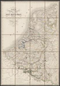
Carte physique et routière du royaume des Pays-Bas indiquant les canaux de différentes classes, les relais de poste et leurs distances intermediaires
1 : 600000 par J. Andriveau géographe gravé au burin par Piat ; la lettre par Arnoul. Paris : chez J. Goujon & J. Andriveau ...
[Kaart], uit: Orandakoku zenzu / Senseki Takami
1 : 600000 Annotatie: Facs. van de uitg.: Furukawa : Kakindō, 1850; Lit.: The world in Japanese maps until the mid-19th century, p. 207; Annotatie geografische gegevens: West boven Takami, Senseki [Tokyo : Noma Kakagu Igaku Kenyu Shiryokan]
The Kingdom of the Netherlands
1 : 1500000 engraved by J. & C. Walker. London : Baldwin & Cradock
Belgique et Hollande
1 : 1300000 Thuillier, Louis; Hachette. Bibliothèque géographique. Firme Paris : Hachette et cie.
Nieuwe kaart van het Koningryk der Nederlanden en het Groot-hertogdom Luxemburg
1 : 600000 Belgie Weygand, F. J. Baarsel, Cornelis van
Niederlande, Belgien.
1 : 1470000 Flemming, Carl
Regni di Olanda e del Belgio, e Gran Ducato di Luembourg.
1 : 1010000 Marzolla, Benedetto
Pays-Bas, Belgique, Luxembourg.
1 : 1000000 Levasseur, E.
Království Hollandské (Nizozemsko), Království Belgické
Belgie Hynek Fuchs
44. Belgio e Olanda.
1 : 1500000 Touring club italiano
Nieuwe kaart van het Koningrijk der Nederlanden en het Groot-Hertogdom Luxemburg : met aanwijzing der nieuwe postwegen = Nouvelle carte du Royaume des Pays-Bas et du Grand-Duché de Luxembourg : avec les routes de poste / dressé et gravé par C. van Baarsel et Fils
1 : 580000 Baarsel, C. van La Haye : F.J. Weygand
Carte du Royaume des Pays-Bas.
1 : 1360000 Vivien de St Martin, L.
Holland and Belgium.
1 : 1290000 Colton, G.W.
Das Koenigreich der Niederlande nebst dem Grossherzogthume Luxemburg
1 : 925000 Belgie Weiland, Karl Ferdinand Geographisches Institut
The Kingdom of the Netherlands
1 : 1495000 Belgie Walker, C. Baldwin & Gradock
Belgique, Hollande, Limbourg, Luxembourg.
1 : 1000000 Picquet, C.
Das Königreich der Niederlande, das Königreich Belgien und das Groszherzogthum Luxemburg
1 : 950000 entworfen und gezeichnet von C.F. Weiland. Weimar : im Verlage des Geogr. Instituts
Holland, Belgium, and Switzerland.
1 : 1360000 Johnson, A.J.
Hollande, Belgique.
1 : 1070000 Andriveau-Goujon, J.
Holland and Belgium.
1 : 1300000 Colton, G.W.
Netherlands.
1 : 1237000 Teesdale, Henry

Belgique et de Hollande, 1812.
1 : 3500000 Malte-Brun, Conrad, 1775-1826
Niederlande, Belgien, Luxemburg
Hand-Atlas über alle Theile der Erde nach dem neuesten Zustande und über das Weltgebäude Stieler, Adolf bei Justus Perthes
Belgium, Netherlands, Luxembourg. Pergamon World Atlas.
Polish Army Topography Service
Niederlande und Belgien
E. von Sydow's Schul-Atlas in sechs und dreissig Karten Sydow, Emil von bei Justus Perthes
Pays-Bas et Belgique.
1 : 1180000 Migeon, J.
[Historisch-geographischer Atlas zu den allgemeinen Geschichtswerken von C. v. Rotteck, Pölitz u. Becker] : Die Niederlande zur Uebersicht der Hauptbegebenheiten
von Julius Loewenberg Lithographie von B. Herder zu Freiburg im Breisgau [Freiburg im Breisgau] : [Herder]
Holland and Belgium.
1 : 1330560 Colton, G.W.