Maps of Germany
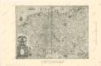
Germaniae nova et accurata delineatio [Karte], in: Gerardi Mercatoris et I. Hondii Newer Atlas, oder, Grosses Weltbuch, Bd. 1, S. 142.
1 Karte aus Atlas Mercator, Gerhard und Hondius, Jodocus Jansson, Jan
NOVA TOTIVS GERMANIÆ DESCRIPTIO
[Amsterdam : Joan Blaeu]
Die Ältesten Karten von Deutschland

Germania Vindelicia Rhaetia Noricum et Pannonia
Germanien, Pannonien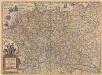
Germaniae nova et accurata delineatio [Karte], in: Novus atlas absolutissimus, Bd. 2, S. 13.
1 Karte aus Atlas Janssonius Offizin
Germania Totivs Evropae Regnum amplissimum ac florentissimum Sedes Imperatoria
1 : 3700000 Overadt, Peter Ouerradius
GERMANIAE | VETERIS | typus.
[Amsterdam : Joan Blaeu]
Carte générale d'Allemagne
1 : 3760000 Evropa střední Mentelle, Edme Tardieu, Pierre François
Germania
1 : 3100000 Mollova mapová sbírka Ortelius, Abraham
Germany.
1 : 5200000 Darton, William
Nova Germaniae Descriptio
1 : 3100000 Mollova mapová sbírka Janssonius, Johannes Janssonius, Johannes I
General Charte von Teutschland mit Angabe aller Post-Strassen von Paris bis Warschau, und von Triest bis Stralsund
1 : 1760000 Evropa střední Güssefeld, Franz L. Geograph. Institut
Neueste Post-Karte durch ganz Deutschland, Helvetien, Ober Italien, Oestreich, Ungarn, Pohlen, Preussen, Dänemark, Holland und Frankreich bis Paris
Dánsko Ulrich, C. F. Börner Fr. Wilmans
Germaniae Veteris, typus. [Karte], in: Theatrum orbis terrarum, S. 380.
1 Karte aus Atlas Ortelius, Abraham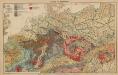
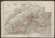
Geologie. II. Mitteleuropa
1 : 3500000 Europa Geologie
Germania [Karte], in: Gerardi Mercatoris Atlas, sive, Cosmographicae meditationes de fabrica mundi et fabricati figura, S. 327.
1 Karte aus Atlas Mercator, Gerhard Montanus, Petrus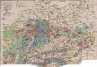
Mitteleuropa Bodenkarte
1 : 6000000 Mitteleuropa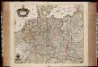
Tabula Germaniae / emendata recens per Nicolaum Joh. Piscatorem ; A. vanden Broeck sculp.
1 : 2700000 Annotatie: Linksonder: "cum privilegio; Origineel is Blad 63 in atlas factice Visscher, Claes Jansz.; Broeck, Abraham van den [Amsterdam : Nicolaes Visscher]
Germania Augustiniana exhibens provincias ord. Fr.Fr. eremit. S. Augustini una cum monasterys et residentiis ad aßistentiam generalem utriusque Germaniae, Bohemiae, Moraviae, Poloniae, Hungariae, et Hyberniae pertinentibus
1 : 2600000 Evropa střední Seutter, Matthäus Seutter, Johann Matthäus Matthaeus Seutter
Eisenbahnen in Deutschland und dessen Grenzlaendern
1 : 6200000 Evropa střední Radefeld Zipter, J. geographischen Anstalt des Bibliographischen Instituts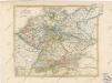
General Karte von Deutschland

Deutschland, Niederlande, Belgien und Schweiz
Hand-Atlas über alle Theile der Erde nach dem neuesten Zustande und über das Weltgebäude Stieler, Adolf bei Justus Perthes
Uebersichts-Karte aller in Deutschland

Germania Augustiniana
1 : 3700000 Mollova mapová sbírka Seutter, Matthäus Seutter, Matthäus
Post- & Reise- Karte von Deutschland und den nachbar Staaten
1 : 2200000 Evropa střední Kunsch, H. Handtke, F. C. Flemming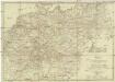
Neueste Post Karte von Deutschland und dessen angrenzenden Länder
Evropa střední Jättnig, Karl Simon Schropp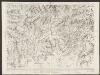
Nova Totius Germaniae Descriptio. [Karte], in: Theatrum orbis terrarum, sive, Atlas novus, Bd. 1, S. 120.
1 Karte aus Atlas Blaeu, Joan Blaeu, Willem Janszoon
Post und Reise Karte von Deutschland und den benachbarten Ländern
Evropa střední Schmitfeldt, Georg Mollo, Eduard bey Eduard Mollo
![Germaniae nova et accurata delineatio [Karte], in: Gerardi Mercatoris et I. Hondii Newer Atlas, oder, Grosses Weltbuch, Bd. 1, S. 142.](https://images-2.georeferencer.com/images/iiif/550748857957/full/,300/0/native.jpg)

