Maps of Germany

Germania [Karte], in: Gerardi Mercatoris Atlas, sive, Cosmographicae meditationes de fabrica mundi et fabricati figura, S. 327.
1 Karte aus Atlas Mercator, Gerhard Montanus, Petrus
Deutschland von 1649 bis 1792.
1 : 3800000 Spruner von Merz, Karl
Post Charte der Östereichis = Teutschen, Preussischen u. Teut. Bund. Staaten...

Germaniae Veteris, typus. [Karte], in: Theatrum orbis terrarum, sive, Atlas novus, Bd. 1, S. 316.
1 Karte aus Atlas Blaeu, Joan Blaeu, Willem Janszoon
Allemagne. Politique et économique. n133
1 : 2600000 A. Taride Paris : A.Taride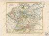
General Karte von Deutschland

Germaniae Veteris, typus. [Karte], in: Novus Atlas, das ist, Weltbeschreibung, Bd. 1, S. 291.
1 Karte aus Atlas Blaeu, Joan Blaeu, Willem Janszoon
Germaniae Veteris, typus. [Karte], in: Le théâtre du monde, ou, Nouvel atlas contenant les chartes et descriptions de tous les païs de la terre, Bd. 1, S. 320.
1 Karte aus Atlas Blaeu, Willem Janszoon und Blaeu, Joan Blaeu, Willem Janszoon
Deutschland, Ubersicht Des Deutschen Reichs.
1 : 3700000 Berghaus, Hermann
Deutschland Und Benachbarte Lander. Zur Ubersicht Der Eisenbahnen Und Dampfschiffahrten.
1 : 3700000 Vogel, C.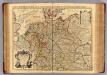
L'Allemagne.
1 : 2500000 L'Isle, Guillaume de, 1675-1726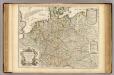
L'Allemagne.
1 : 2500000 L'Isle, Guillaume de, 1675-1726
Carte générale d'Allemagne
1 : 3760000 Evropa střední Mentelle, Edme Tardieu, Pierre François
[Deutschland, Niederlande, Belgien und Schweiz; National-, Sprach-, Dialect- Verschiedenheit]
Zweiter Band, enthaltend in vier Abtheilungen die Vertheilung der Organismen: 5. Pflanzen-Geographie, 6. Thier-Geographie, 7. Anthropographie, 8. Ethnographie Humboldt, Alexander von Verlag von Justus Perthes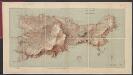
L' Empire D'Allemagne [...] [Karte], in: Atlas nouveau, contenant toutes les parties du monde [...], Bd. 1, S. 161.
1 Karte aus Atlas Sanson, Nicolas Jaillot, Alexis Hubert und Mortier, Pieter
Deutschland, Übersicht des Deutschen Reichs
Handatlas über alle Theile der Erde und über das Weltgebäude Stieler, Adolf Justus Perthes
Nova Totius Germaniae Descriptio. [Karte], in: Novus Atlas, das ist, Weltbeschreibung, Bd. 1, S. 79.
1 Karte aus Atlas Blaeu, Joan Blaeu, Willem Janszoon
Mitteleuropa Übersicht der politischen Verhältnisse und Hauptverkehrswege
1 : 5000000 Mitteleuropa Verkehrsnetz
Germaniae Veteris, typus. [Karte], in: Gerardi Mercatoris et I. Hondii Newer Atlas, oder, Grosses Weltbuch, Bd. 1, S. 135.
1 Karte aus Atlas Mercator, Gerhard und Hondius, Jodocus Jansson, Jan
Deutschland und benachbarte Länder. Zur Übersicht der Eisenbahnen und Dampfschiffahrten
Hand-Atlas über alle Theile der Erde und über das Weltgebäude Stieler, Adolf Justus Perthes
Germania Augustiniana
1 : 3700000 Mollova mapová sbírka Seutter, Matthäus Seutter, Matthäus
Mitteleuropa Übersicht der Bodenverhältnisse
1 : 5000000 Mitteleuropa
Telegrafenlinien, Eisenbahnen und Dampfbootfahrten in Deutschland und den Nachbarstaaten
Evropa střední Raffelsperger, Franz Franz Raffelsperger
Post- und Reisekarte von Deutschland, den Niederlanden, Belgien und der Schweiz
1 : 2470000 Belgie Bachmann, Friedrich Nast Friedr. Kornschen Buchhandlung
Post- und Reisekarte von Deutschland, den Niederlanden, Belgien und der Schweiz
1 : 2470000 Belgie Bachmann, Friedrich Nast Friedr. Kornschen Buchhandlung
Nova Totius Germaniae Descriptio. [Karte], in: Le théâtre du monde, ou, Nouvel atlas contenant les chartes et descriptions de tous les païs de la terre, Bd. 1, S. 102.
1 Karte aus Atlas Blaeu, Willem Janszoon und Blaeu, Joan Blaeu, Willem Janszoon
Post- und Reise-Charte von Deutschland und den benachbarten Laendern / nach den neuesten Quellen entw. von C.F. Weiland ; C.J. Maedel sculps.
1 : 1500000 Annotatie geografische gegevens: Grenzen gekleurd Weiland, C. F.; Maedel, C. J. Weimar : Geogr. Institut
Germania Augustiniana exhibens provincias ord. Fr.Fr. eremit. S. Augustini una cum monasterys et residentiis ad aßistentiam generalem utriusque Germaniae, Bohemiae, Moraviae, Poloniae, Hungariae, et Hyberniae pertinentibus
1 : 2600000 Evropa střední Seutter, Matthäus Seutter, Johann Matthäus Matthaeus Seutter
Deutschland Politische Uebersicht
Plastischer Schul-Atlas über alle Theile der Erde : in 24 Karten Woldermann, G Verlag von P. Eckerlein
Post- & Reise-Karte von Deutschland und den nachbar Staaten
Evropa střední Handtke, Friedrich Flemming, C. C. Flemming
![Germania [Karte], in: Gerardi Mercatoris Atlas, sive, Cosmographicae meditationes de fabrica mundi et fabricati figura, S. 327.](https://images-2.georeferencer.com/images/iiif/350098472262/full/,300/0/native.jpg)

