Maps of Germany

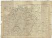
Germania Vindelicia Rhaetia Noricum et Pannonia
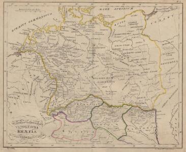
Germanien, Pannonien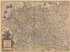
Germaniae nova et accurata delineatio [Karte], in: Novus atlas absolutissimus, Bd. 2, S. 13.
1 Karte aus Atlas Janssonius Offizin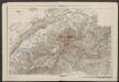
Germaniae nova et accurata delineatio [Karte], in: Gerardi Mercatoris et I. Hondii Newer Atlas, oder, Grosses Weltbuch, Bd. 1, S. 142.
1 Karte aus Atlas Mercator, Gerhard und Hondius, Jodocus Jansson, Jan
NOVA TOTIVS GERMANIÆ DESCRIPTIO
[Amsterdam : Joan Blaeu]
GERMANIAE | VETERIS | typus.
[Amsterdam : Joan Blaeu]

Carte générale d'Allemagne
1 : 3760000 Evropa střední Mentelle, Edme Tardieu, Pierre François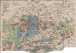
Mitteleuropa Bodenkarte
1 : 6000000 Mitteleuropa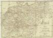
Neueste Post Karte von Deutschland und dessen angrenzenden Länder
Evropa střední Jättnig, Karl Simon Schropp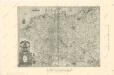
Die Ältesten Karten von Deutschland

General Charte von Teutschland mit Angabe aller Post-Strassen von Paris bis Warschau, und von Triest bis Stralsund
1 : 1760000 Evropa střední Güssefeld, Franz L. Geograph. Institut
Nova Germaniae Descriptio
1 : 3100000 Mollova mapová sbírka Janssonius, Johannes Janssonius, Johannes I
Neueste Post-Karte durch ganz Deutschland, Helvetien, Ober Italien, Oestreich, Ungarn, Pohlen, Preussen, Dänemark, Holland und Frankreich bis Paris
Dánsko Ulrich, C. F. Börner Fr. Wilmans
Germany.
1 : 5200000 Darton, William
Geschäfts- und Reise-Tableau für Deutschland und die angränzenden Länder
1 : 3620000 Německo Seitz, Johan Baptista Ioh. Bapt. Seitz
Germania
1 : 3100000 Mollova mapová sbírka Ortelius, Abraham
Germania [Karte], in: Gerardi Mercatoris Atlas, sive, Cosmographicae meditationes de fabrica mundi et fabricati figura, S. 327.
1 Karte aus Atlas Mercator, Gerhard Montanus, Petrus
Uebersichts-Karte aller in Deutschland

Germania Augustiniana
1 : 3700000 Mollova mapová sbírka Seutter, Matthäus Seutter, Matthäus
Germania Totivs Evropae Regnum amplissimum ac florentissimum Sedes Imperatoria
1 : 3700000 Overadt, Peter Ouerradius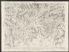
Nova Totius Germaniae Descriptio. [Karte], in: Theatrum orbis terrarum, sive, Atlas novus, Bd. 1, S. 120.
1 Karte aus Atlas Blaeu, Joan Blaeu, Willem Janszoon
Deutschland von 1649 bis 1792.
1 : 3800000 Spruner von Merz, Karl
Post Charte der Östereichis = Teutschen, Preussischen u. Teut. Bund. Staaten...

Neueste Generalkarte von Deutschland nach den zehn Kreisen und ihren Unterabtheilungen
1 : 2845000 Evropa střední
CHARTE von DEUTSCHLAND
1 : 3600000 Německo
Charte von Deutschland
1 : 3580000 Evropa střední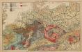
Geologie. II. Mitteleuropa
1 : 3500000 Europa Geologie
Germaniae Veteris, typus. [Karte], in: Novus Atlas, das ist, Weltbeschreibung, Bd. 1, S. 291.
1 Karte aus Atlas Blaeu, Joan Blaeu, Willem Janszoon
Deutschland nach seiner neuesten Grenz-Berichtigung
1 : 2350000 Evropa střední Mollo, Tranquillo T. Mollo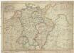
Deutschland nach seiner neuesten Grenz-berichtigung
1 : 2350000 Evropa střední Mollo, Tranquillo T. Mollo