Maps of Germany
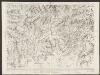
Nova Totius Germaniae Descriptio. [Karte], in: Theatrum orbis terrarum, sive, Atlas novus, Bd. 1, S. 120.
1 Karte aus Atlas Blaeu, Joan Blaeu, Willem Janszoon
Nova Totius Germaniae Descriptio. [Karte], in: Le théâtre du monde, ou, Nouvel atlas contenant les chartes et descriptions de tous les païs de la terre, Bd. 1, S. 102.
1 Karte aus Atlas Blaeu, Willem Janszoon und Blaeu, Joan Blaeu, Willem Janszoon
Nova Totius Germaniae Descriptio. [Karte], in: Novus Atlas, das ist, Weltbeschreibung, Bd. 1, S. 79.
1 Karte aus Atlas Blaeu, Joan Blaeu, Willem Janszoon
Uebersichts-Karte aller in Deutschland

Tabula Germaniae emendata recens [Karte], in: Novus atlas absolutissimus, Bd. 2, S. 16.
1 Karte aus Atlas Janssonius Offizin
Neueste Post-Karte durch ganz Deutschland, Helvetien, Ober Italien, Oestreich, Ungarn, Pohlen, Preussen, Dänemark, Holland und Frankreich bis Paris
Dánsko Ulrich, C. F. Börner Fr. Wilmans
Post- & Reise-Karte von Deutschland und den nachbar Staaten
Evropa střední Handtke, Friedrich Flemming, C. C. Flemming
Post- & Reise-Karte von Deutschland und den nachbar Staaten
Evropa střední Handtke, Friedrich Weber, H. C. Fleming
Deutschland Politische Uebersicht
Plastischer Schul-Atlas über alle Theile der Erde : in 24 Karten Woldermann, G Verlag von P. Eckerlein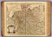
L'Allemagne.
1 : 2500000 L'Isle, Guillaume de, 1675-1726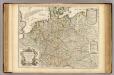
L'Allemagne.
1 : 2500000 L'Isle, Guillaume de, 1675-1726
Deutschland, Ubersicht Des Deutschen Reichs.
1 : 3700000 Berghaus, Hermann
Deutschland Und Benachbarte Lander. Zur Ubersicht Der Eisenbahnen Und Dampfschiffahrten.
1 : 3700000 Vogel, C.
Post- und Reisekarte von Deutschland, den Niederlanden, Belgien und der Schweiz
1 : 2470000 Belgie Bachmann, Friedrich Nast Friedr. Kornschen Buchhandlung
Post- und Reisekarte von Deutschland, den Niederlanden, Belgien und der Schweiz
1 : 2470000 Belgie Bachmann, Friedrich Nast Friedr. Kornschen Buchhandlung
Mitteleuropa Übersicht der Bodenverhältnisse
1 : 5000000 Mitteleuropa
Germania Augustiniana exhibens provincias ord. Fr.Fr. eremit. S. Augustini una cum monasterys et residentiis ad aßistentiam generalem utriusque Germaniae, Bohemiae, Moraviae, Poloniae, Hungariae, et Hyberniae pertinentibus
1 : 2600000 Evropa střední Seutter, Matthäus Seutter, Johann Matthäus Matthaeus Seutter
Deutschland und benachbarte Länder. Zur Übersicht der Eisenbahnen und Dampfschiffahrten
Hand-Atlas über alle Theile der Erde und über das Weltgebäude Stieler, Adolf Justus Perthes
Mitteleuropa Übersicht der politischen Verhältnisse und Hauptverkehrswege
1 : 5000000 Mitteleuropa Verkehrsnetz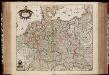
Tabula Germaniae / emendata recens per Nicolaum Joh. Piscatorem ; A. vanden Broeck sculp.
1 : 2700000 Annotatie: Linksonder: "cum privilegio; Origineel is Blad 63 in atlas factice Visscher, Claes Jansz.; Broeck, Abraham van den [Amsterdam : Nicolaes Visscher]
Das Deutsche Reich und seine Nachbarländer. Zur Übersicht der Eisenbahnen und Dampfschiffahrten
Handatlas über alle Theile der Erde und über das Weltgebäude Stieler, Adolf Justus Perthes

Deutschland 1555
Deutschland Kunz, Andreas ; Moeschl, Joachim Robert
Post und Reise - Karte von Deutschland...

Deutschland, Übersicht des Deutschen Reichs
Handatlas über alle Theile der Erde und über das Weltgebäude Stieler, Adolf Justus Perthes
Post- und Reise-Charte von Deutschland und den benachbarten Laendern / nach den neuesten Quellen entw. von C.F. Weiland ; C.J. Maedel sculps.
1 : 1500000 Annotatie geografische gegevens: Grenzen gekleurd Weiland, C. F.; Maedel, C. J. Weimar : Geogr. Institut
Germany.
1 : 3000000 Andree, Richard; Times (London, England)
Germaniae Veteris, typus. [Karte], in: Le théâtre du monde, ou, Nouvel atlas contenant les chartes et descriptions de tous les païs de la terre, Bd. 1, S. 320.
1 Karte aus Atlas Blaeu, Willem Janszoon und Blaeu, Joan Blaeu, Willem Janszoon
Deutschland 1648
Deutschland Kunz, Andreas ; Moeschl, Joachim Robert
![Nova Totius Germaniae Descriptio. [Karte], in: Theatrum orbis terrarum, sive, Atlas novus, Bd. 1, S. 120.](https://images-2.georeferencer.com/images/iiif/520801578855/full/,300/0/native.jpg)

