Maps of Germany

Die Ältesten Karten von Deutschland
Germaniae nova et accurata delineatio [Karte], in: Novus atlas absolutissimus, Bd. 2, S. 13.
1 Karte aus Atlas Janssonius Offizin
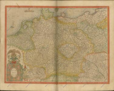
Germaniae nova et accurata delineatio [Karte], in: Gerardi Mercatoris et I. Hondii Newer Atlas, oder, Grosses Weltbuch, Bd. 1, S. 142.
1 Karte aus Atlas Mercator, Gerhard und Hondius, Jodocus Jansson, Jan
NOVA TOTIVS GERMANIÆ DESCRIPTIO
[Amsterdam : Joan Blaeu]
Germania Totivs Evropae Regnum amplissimum ac florentissimum Sedes Imperatoria
1 : 3700000 Overadt, Peter Ouerradius
Germania Vindelicia Rhaetia Noricum et Pannonia
Germanien, Pannonien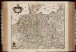
Tabula Germaniae / emendata recens per Nicolaum Joh. Piscatorem ; A. vanden Broeck sculp.
1 : 2700000 Annotatie: Linksonder: "cum privilegio; Origineel is Blad 63 in atlas factice Visscher, Claes Jansz.; Broeck, Abraham van den [Amsterdam : Nicolaes Visscher]
Carte générale d'Allemagne
1 : 3760000 Evropa střední Mentelle, Edme Tardieu, Pierre François
GERMANIAE | VETERIS | typus.
[Amsterdam : Joan Blaeu]
Post- & Reise- Karte von Deutschland und den nachbar Staaten
1 : 2200000 Evropa střední Kunsch, H. Handtke, F. C. Flemming
Post und Reise Karte von Deutschland und den benachbarten Ländern
Evropa střední Schmitfeldt, Georg Mollo, Eduard bey Eduard Mollo
Germaniae Veteris, typus. [Karte], in: Theatrum orbis terrarum, S. 380.
1 Karte aus Atlas Ortelius, Abraham
Eisenbahnen in Deutschland und dessen Grenzlaendern
1 : 6200000 Evropa střední Radefeld Zipter, J. geographischen Anstalt des Bibliographischen Instituts
Eisenbahn-Karte von Deutschland
Evropa střední Rudolf Moose
Germany.
1 : 5200000 Darton, William
Neueste Post-Karte durch ganz Deutschland, Helvetien, Ober Italien, Oestreich, Ungarn, Pohlen, Preussen, Dänemark, Holland und Frankreich bis Paris
Dánsko Ulrich, C. F. Börner Fr. Wilmans
Deutschland von 1495 bis 1618.
1 : 3800000 Spruner von Merz, Karl
Germaniae Veteris, typus. [Karte], in: Theatrum orbis terrarum, S. 473.
1 Karte aus Atlas Ortelius, Abraham Vrients, Jan Baptista
Germania
1 : 3100000 Mollova mapová sbírka Ortelius, Abraham
Germania Augustiniana exhibens provincias ord. Fr.Fr. eremit. S. Augustini una cum monasterys et residentiis ad aßistentiam generalem utriusque Germaniae, Bohemiae, Moraviae, Poloniae, Hungariae, et Hyberniae pertinentibus
1 : 2600000 Evropa střední Seutter, Matthäus Seutter, Johann Matthäus Matthaeus Seutter
Germania [Karte], in: Gerardi Mercatoris Atlas, sive, Cosmographicae meditationes de fabrica mundi et fabricati figura, S. 327.
1 Karte aus Atlas Mercator, Gerhard Montanus, Petrus
General Charte von Teutschland mit Angabe aller Post-Strassen von Paris bis Warschau, und von Triest bis Stralsund
1 : 1760000 Evropa střední Güssefeld, Franz L. Geograph. Institut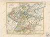
General Karte von Deutschland

Historia Imperii Romano-Germanici, nec non finitimarum Regionum In Mappa exhibita, ac aeri incisa
1 : 2500000 Mollova mapová sbírka Seutter, Matthäus Seutter, Matthäus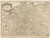
L'empire d'Allemagne
1 : 2600000 Evropa střední Sanson, Guillaume Cordier, Louis chez H. Iaillot
Imperium Romano-Germanicum in suos circulos electorat. et status
1 : 5100000 Evropa střední Seutter, Matthäus Lotter, Tobias Conrad apud Matth. Seutter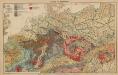
Geologie. II. Mitteleuropa
1 : 3500000 Europa Geologie
Deutschland's kirchliche Eintheilung bis in das XVIte. Jahrhundert.
1 : 3800000 Spruner von Merz, Karl