Maps of Banten

To Captain Krusenstern, of the Imperial Russian Navy, as a tribute for his laudable exertions to benefit navigation and maritime science
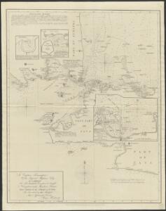
1 : 443750 this chart of the Strait of Sunda is inscribed by [...] James Horsburgh [London] : by James Horsburgh, hydrographer to the Hon.ble East India Co.
Kaart van Straat Soenda : overgenomen van de Zeekaart van 1870 / get[ekend door] J.G. de Groot
Bruxelles : Institut National de Géographie
Kaart van Het Gedeelte Java en Sumatra
1 : 500000 Jáva (Indonésie) Eckstein, G. A. Gebroeders Van Cleef
[Teloekbetoeng]
Topografische Dienst Batavia Batavia : Reproductiebedrijf Topografische Dienst
West-Java / Reproductiebedrijf Top. dienst (Reproduced by Topographical Service)
Officieële Vereeniging voor Toeristenverkeer in Nederlandsch-Indië Batavia Batavia : Travellers Official Information Bureau
Overzichtskaart van de residentie Bantam / Topogr[afische] Inrichting
Topografische Inrichting Batavia Batavia : Topogr[afische] Inrichting
Kaart van de Residentie Bantam : op de schaal van 1:20.000 (gedeeltelijk ook op schaal van 1:40.000) opgenomen ingevolge Gouvernements Besluit d.d. 6 juli 1866, No. 8, in de jaren 1878 t/m 1885 / Topographisch Bureau van de Generale Staf, Batavia
Topographisch Bureau van de Generale Staf Batavia [Batavia : Topographisch Bureau van de Generale Staf]
Overzichtskaart van den ontworpen spoorweg van Batavia naar Anjer : met zijtakken van Doerie naar Tangerang en van Tanahabang naar Weltevreden
Bataviaasch Nieuwsblad Batavia ; Weltevreden : G. Kolff & Co.
Teloekbetoeng / published by War Office = uitgegeven door War Office ; revised and photolithographed by War Office
War Office Washington D.C. [Washington D.C.] : War Office
Batavia / prepared under the direction of the Chief of Engineers U.S. Army by the Army Map Service
Army Map Service Washington D.C. Washington D.C. : Army Map Service
Laboehan / prepared under the direction of the Chief of Engineers U.S. Army by the Army Map Service
Army Map Service Washington D.C. Washington D.C. : Army Map Service
[Sukabumi]
1 : 200000 Joh. C. Stemler Cz.
[Sundastrasse]
1 : 200000 Joh. C. Stemler Cz.
[Tugu]
1 : 200000 Joh. C. Stemler Cz.
[Jakarta]
1 : 200000 Joh. C. Stemler Cz.
Overzichtskaart van de residentie Batavia / [door het] Topographisch Bureau
Topographisch Bureau Batavia Batavia : Topographisch Bureau
Batavia

Kaart van de Residentie Batavia

Soekaboemi / prepared under the direction of the Chief of Engineers, U.S. Army by the Army Map Service
Army Map Service Washington D.C. Washington D.C. : Army Map Service
Kota·agoeng / [bew. door J. Zwierzycki]
Dienst van den Mijnbouw in Nederlandsch-Indië Batavia [Batavia] : Dienst van den Mijnbouw in Nederlandsch-Indië
Kotaboemi / [bew. door J. Westerveld]
Dienst van den Mijnbouw in Nederlandsch-Indië Batavia [Batavia] : Dienst van den Mijnbouw in Nederlandsch-Indië
Kaart van een gedeelte van Straat Soenda : ter berekening van de hoeveelheid uitgeworpen stoffen / get[ekend door] J.G. de Groot
Bruxelles : Institut National de Géographie
[Pamatanggawan] : bijgewerkt t/m April 1894 / [Topographisch Bureau]
Topographisch Bureau Batavia [Batavia : Topographisch Bureau]
Kaart van het vaarwater uit Straat Sunda naar en op de reede van Batavia : bevattende het gedeelte tusschen het eiland Menschen-eeter en den hoek van Krawang verbeterd bij de herstelling der zeebaken [...] 1832
1 : 85000 Gecopieerd door Zecha den 25/10 1833 Lith. Ch. Motte [S.l.] : [s.n.]
[Java und Madoera, geologische Detailkarten und Profile]
Blatt 16 Verbeek, R. D. M. Joh. C. Stemler Cz.
Geologische kaart van Krakatau : na de uitbarsting van 1883
Institut National de Géographie Bruxelles Bruxelles : Institut National de Géographie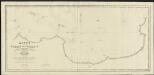
Kaart van de Reede van Batavia met de verschillende vaarwaters
1 : 50000 naar dezelve trigonometrisch opgenomen op last van den Schout Bijnacht E. Lucas door de Luitenants ter Zee B.G. Escher. L.A.C. Eschauzier, B.H. Staring, E.H. Boom en andere officieren van Z.M. Zeemagt uitg. door Jacob Swart ; gegraveerd door J.C. Zurcher ; getekend door G. A. Günther Amsterdam : Wed. G. Hulst van Keulen
Buitenzorg-Soekaboemi-Tjiandjoer / Topografische Inrichting = Topographical Service
Topografische Inrichting Batavia Batavia : Topografische Inrichting = Topographical Service
Buitenzorg-Soekaboemi-Tjiandjoer / Topografische Inrichting, Batavia
Topografische Inrichting Batavia Batavia : Officieële Vereeniging voor Toeristen Verkeer