Maps of West Java
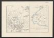
[Java und Madoera, geologische Detailkarten und Profile]
Blatt 16 Verbeek, R. D. M. Joh. C. Stemler Cz.
Java, Bie Winkoups (1867)
Bie Winkoups, d'après, le Lieutt. Hampt ... 1837. Paris
[Geologische Kaart van de omstreken der Tjiletoe-Baai]
[Java und Madoera, geologische Detailkarten und Profile] Verbeek, R. D. M. Joh. C. Stemler Cz.
[Tjitjoeroeg] / [Topographisch Bureau]
Topographisch Bureau Batavia [Batavia : Topographisch Bureau]
[Tjimanggoe] / [Topographisch Bureau]
Topographisch Bureau Batavia [Batavia : Topographisch Bureau]
[Lengkong] / [Topographisch Bureau]
Topographisch Bureau Batavia [Batavia : Topographisch Bureau]
[Tjiboetoen] / Topographisch Bureau
Topographisch Bureau Batavia Batavia : Topographisch Bureau
[Tjiboentjoe] / Topographisch Bureau
Topographisch Bureau Batavia Batavia : Topographisch Bureau
[Waloeran] / [Topographisch Bureau]
Topographisch Bureau Batavia [Batavia : Topographisch Bureau]
[Tjimandiri] / Topographisch Bureau
Topographisch Bureau Batavia Batavia : Topographisch Bureau
[Tjidadap] / Topographisch Bureau
Topographisch Bureau Batavia Batavia : Topographisch Bureau
[Djampang Tengah] / photolithographed and reprinted from a Dutch map dated 1925 by the Army Map Service
Army Map Service U.S. Army Washington D.C. Washington D.C. : Army Map Service
[Tjilandak] / Topographisch Bureau
Topographisch Bureau Batavia Batavia : Topographisch Bureau
[Nangka] / Topographisch Bureau
Topographisch Bureau Batavia Batavia : Topographisch Bureau
[Tjikaso] / [Topographisch Bureau]
Topographisch Bureau Batavia [Batavia : Topographisch Bureau]
Soekaboemi / prepared under the direction of the Chief of Engineers, U.S. Army by the Army Map Service
Army Map Service Washington D.C. Washington D.C. : Army Map Service
[Sukabumi]
1 : 200000 Joh. C. Stemler Cz.
[Tjilong Krang] / [Topographisch Bureau van de Generale Staf]
Topographisch Bureau van de Generale Staf Batavia [Batavia : Topographisch Bureau van de Generale Staf]
[Tjidjengkol] : bijgewerkt t/m april 1894 / [Topographisch Bureau]
Topographisch Bureau Batavia [Batavia : Topographisch Bureau]
[Tjaoe Mangala] / Topographisch Bureau
Topographisch Bureau Batavia Batavia : Topographisch Bureau
[Palaboehan Ratoe] / Topographisch Bureau
Topographisch Bureau Batavia Batavia : Topographisch Bureau
To Captain Krusenstern, of the Imperial Russian Navy, as a tribute for his laudable exertions to benefit navigation and maritime science
1 : 443750 this chart of the Strait of Sunda is inscribed by [...] James Horsburgh [London] : by James Horsburgh, hydrographer to the Hon.ble East India Co.
West-Java : met aanwijzing van de bevolkingsdichtheid per district volgens de uitkomsten der volkstelling in 1930
Topografische Dienst Batavia [Batavia : Topografische Dienst]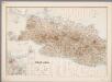
3. West Java, uit: Atlas van Nederlandsch Oost-Indië / samengest. door Topographisch Bureau te Batavia van 1897-1904
Annotatie: Omgewerkte versie van: Atlas der Nederlandsche bezittingen in Oost-Indië / naar de nieuste bronnen samengest. door J.W. Stemfoort en J.J. ten Siethoff. - 's-Gravenhage : Topographische Inrichting, [ca. 1885] Topographisch Bureau, Batavia 's-Gravenhage : Topographische Inrichting
West-Java / Topografische Dienst
Topografische Dienst Batavia Batavia : Reproductiebedrijf Topografische Dienst
West-Java : bijgewerkt tot 1 November 1935 / Reproductiebedrijf Topografische Dienst
Topografische Dienst Batavia Batavia : Topografische Dienst
Kaart van West-Java : Eerste militaire afdeeling / [door J.W Stemfoort en J.J. ten Siethoff ; gereproduceerd op last van het Departement van Koloniën, aan de Topographische Inrichting te 's-Gravenhage, onder leiding van den Directeur C.A. Eckstein]
Ministerie van Koloniën Den Haag s-Gravenhage : Departement van Koloniën
Djawa Barat
Bandung : 'Hovic' Visser
Kaart van het Rijk van Bantam, Jacatra & Cheribon op het eiland Java / door Js. van den Bosch ; gegraveerd door C. van Baarsel en Zoon
C. van Baarsel en Zoon s-Gravenhage ; Amsterdam : Gebroeders van Cleef
![[Java und Madoera, geologische Detailkarten und Profile]](https://images-2.georeferencer.com/images/iiif/579628605529/full/,300/0/native.jpg)

