Maps of Grand Est

Karte von Frankreich in XVI Blättern, No. 3 und [No. 7]
2 Blätter : 53 x 34 cm Königl. Preuss. Academischen Kunst und Buchhandlung
France 2.
1 : 1774080 Letts, Son & Co.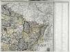
Carte de la France, 2
1 Blatt : 60 x 82 cm de Belleyme
Kriegs Atlas 36 Karten von den Schauplätzen des Weltkrieges 1914/1915

Einsatz der 1./Pz. Rgt. 2 im Westen vom 10. 5. - 6. 9. 1940
Francie Veit Carl Kaestner
Frankreich NO.
1 : 1700000 Berghaus, Heinrich; Flemming, Carl; Handtke, Friedrich H.; Sohr, Karl
Reliefkarte von Nordost-Frankreich


Carte de la France (NE)
1 : 345600 Cassini family
Nordost Frankreich, Belgien und Luxemburg Deutsche Rheinländer

The Western Front. June 1918.
1 : 600000 First World War map of the Western Front. June 1918. Front Line June 12th, June 5th and March 20th. War Office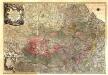
Theatrum Belli Serenissimae Domus Austriacae, Contra Gallos, Confine Limitibus Sacri Romani Imperii et Belgii
1 : 400000 Mollova mapová sbírka Oettinger, Johann Friedrich Lotter, Tobias Conrad Seutter, Matthäus
Western Front. Front line on March 20th, Aug.16th, Sept. 18th 1918.
1 : 600000 First World War map of the Western Front. Front line on March 20th, Aug.16th, Sept. 18th 1918. Shows limits of German advance in 1918. War Office
Flemmings Spezialkarte für den deutsch-französischen Krieg
1 : 600000 Evropa západní Carl Flemming
France Flle. N.E.
1 : 1000000 Vivien St Martin, L.
Zu den Feldzügen 1708 in den Niederlanden und am Rhein
Lille (Francie) Coxe, William K.k. Generalstabes
Allgemeine Uebersicht des Kriegsschauplazes am Rhein, der Mosel, Maas, Marne, Seine, Schelde [et].c.c
1 Karte : Kupferdruck ; 48 x 58 cm Güssefeld bey d. Homann. Erben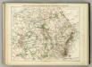
Carte Physique et Militaire de la Frontiere du Nord-Est.
1 : 1000000 Jouvet et Cie.
Champagne latine Campania, Comitatus [Karte], in: Theatrum orbis terrarum, sive, Atlas novus, Bd. 2, S. 53.
1 Karte aus Atlas Blaeu, Joan Blaeu, Willem Janszoon
Champagne latine Campania, Comitatus [Karte], in: Le théâtre du monde, ou, Nouvel atlas contenant les chartes et descriptions de tous les païs de la terre, Bd. 2, S. 57.
1 Karte aus Atlas Blaeu, Willem Janszoon und Blaeu, Joan Blaeu, Willem Janszoon
Champagne latine Campania, Comitatus [Karte], in: Novus Atlas, das ist, Weltbeschreibung, Bd. 2, S. 57.
1 Karte aus Atlas Blaeu, Joan Blaeu, Willem Janszoon
Champagne Comitatus Campania. [Karte], in: Gerardi Mercatoris et I. Hondii Newer Atlas, oder, Grosses Weltbuch, Bd. 2, S. 50.
1 Karte aus Atlas Mercator, Gerhard und Hondius, Jodocus Jansson, Jan
Skizze zur Orientirung ϋber den Feldzug 1807

Province de Cologne, dans la Gaule Belgicque de laquelle
1 : 875000 Mollova mapová sbírka Sanson, Nicolas Mariette, Pierre
Panoramatic View of the frontier between France and Germany
1 : 771000 Francie Meinhard, R. Julius Abelsdorff
France - north-eastern section, environs of Paris.
1 : 1000000 John Bartholomew & Co.
Belgii sive Germaniae accuratissima tabula
Mollova mapová sbírka Hondius, Henricus Janssonius, Johannes I
Neueste Generalkarte von Frankreich, 2
1 Blatt : 55 x 78 cm F.A. Schrämbl
Carte des Pays-Bas Autrichiens
1 : 800000 Belgie Mentelle, Edme Tardieu, Pierre François
![Karte von Frankreich in XVI Blättern, No. 3 und [No. 7]](http://biblio.unibe.ch/web-apps/maps/zoomify.php?pic=Ryh_2206_43.jpg&col=ryh)

