Maps of Grand Est
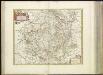
[20][20] Champaigne et Brie etc., uit: Atlas sive Descriptio terrarum orbis
Annotatie: Gedigitaliseerde versie. Amsterdam. Heiloo : Picturae (vervaardiger), 2015. tiff-bestand. Gedigitaliseerd: 07-01-2015; Origineel: Universiteitsbibliotheek Vrije Universiteit (XL.05127.-) ; Netherlands; Titelpagina ontbreekt Wit, Frederik de Amsterdam : Frederick de Wit
Champaigne et Brie etc. [Karte], in: Novus atlas absolutissimus, Bd. 4, S. 65.
1 Karte aus Atlas Janssonius Offizin
Champaigne et Brie
1 : 850000 par Mr Samson Geographe du Roy [S.l.] : [s.n.]
Verwinning der Savojaerden, waer door de Fransen, onder Mo. d'Thouy in Savoje by Conflans aan den inham van de rivier de Arly en de Isere geretrencheert, na een gevegt van 2 uren na den middagh tot 7 uren des avonts, met verlies van ontrent 2000 man, op de vlugt gedreven zyn den 20 iuly 1709
Francie Schenk, Pieter P. Schenk
Einsatz der 1./Pz. Rgt. 2 im Westen vom 10. 5. - 6. 9. 1940
Francie Veit Carl Kaestner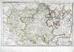
Isle de France, Champagne, Lorraine [et]c
1 Karte : Kupferdruck ; 35 x 57 cm Sanson; Cordier chez l'autheur
France 2.
1 : 1774080 Letts, Son & Co.
Champaigne et Brie
1 Karte : Kupferdruck ; 38 x 44 cm Sanson chez l'autheur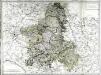
Gouvernement de Champagne
1 Karte auf 4 Blättern : Kupferdruck ; 61 x 82 cm Mentelle; Tardieu Mentelle
Campaniæ præfectura divisum in electiones Rhemorum, Retelii, Catalauni, Augustibonæ, Longonæ, Chamontii, Meldarum, Senonarum
1 Karte : Kupferdruck ; 57 x 48 cm Valck; Valck edentibus Gerardo et Leonardo Valk
Champaigne et Brie etc
1 Karte : Kupferdruck ; 39 x 49 cm Janssonius; Sanson Joannes Janssonius
Kriegs Atlas 36 Karten von den Schauplätzen des Weltkrieges 1914/1915

Flemmings Spezialkarte für den deutsch-französischen Krieg
1 : 600000 Evropa západní Carl Flemming
Champaigne et Brie
1 Karte : Kupferdruck ; 27 x 32 cm Merian Caspar Merian
Champagne Comitatus Campania. [Karte], in: Gerardi Mercatoris et I. Hondii Newer Atlas, oder, Grosses Weltbuch, Bd. 2, S. 50.
1 Karte aus Atlas Mercator, Gerhard und Hondius, Jodocus Jansson, Jan
The Western Front. June 1918.
1 : 600000 First World War map of the Western Front. June 1918. Front Line June 12th, June 5th and March 20th. War Office
Champagne latine Campania, Comitatus [Karte], in: Theatrum orbis terrarum, sive, Atlas novus, Bd. 2, S. 53.
1 Karte aus Atlas Blaeu, Joan Blaeu, Willem Janszoon
Western Front. Front line on March 20th, Aug.16th, Sept. 18th 1918.
1 : 600000 First World War map of the Western Front. Front line on March 20th, Aug.16th, Sept. 18th 1918. Shows limits of German advance in 1918. War Office
Champagne latine Campania, Comitatus [Karte], in: Novus Atlas, das ist, Weltbeschreibung, Bd. 2, S. 57.
1 Karte aus Atlas Blaeu, Joan Blaeu, Willem Janszoon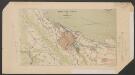
Champagne latine Campania, Comitatus [Karte], in: Le théâtre du monde, ou, Nouvel atlas contenant les chartes et descriptions de tous les païs de la terre, Bd. 2, S. 57.
1 Karte aus Atlas Blaeu, Willem Janszoon und Blaeu, Joan Blaeu, Willem Janszoon
Le Duché de Lorraine & de Bar; le gouvern.t de Champagne et une partie de celui de l'Isle de France &c
1 Karte auf 2 Blättern : Kupferdruck ; 46 x 85 cm Ottens; Ottens chez Rein. et Ios. Ottens
Champagne
1 Karte : Kupferdruck ; 36 x 48 cm Hondius; Mercator Henricus Hondius
Übersichtskarte von Mittel - Europa
France - north-eastern section, environs of Paris.
1 : 1000000 John Bartholomew & Co.
Gouvernement General De Champagne. [...] [Karte], in: Atlas nouveau, contenant toutes les parties du monde [...], Bd. 1, S. 94.
1 Karte aus Atlas Sanson, Nicolas Jaillot, Alexis Hubert und Mortier, Pieter
Karte von Frankreich in XVI Blättern, No. 3 und [No. 7]
2 Blätter : 53 x 34 cm Königl. Preuss. Academischen Kunst und Buchhandlung
Special Karte des Kriegsschauplatzes von Metz bis Paris
1 : 1030000 Mety (Francie) Rachel, L. Verlag von Hermann Schönlein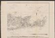
France Picardie Champaigne cum regionibus adiacentibus. [Karte], in: Gerardi Mercatoris Atlas, sive, Cosmographicae meditationes de fabrica mundi et fabricati figura, S. 232.
1 Karte aus Atlas Mercator, Gerhard Montanus, Petrus
![[20][20] Champaigne et Brie etc., uit: Atlas sive Descriptio terrarum orbis](https://images-2.georeferencer.com/images/iiif/710687785058/full/,300/0/native.jpg)

